James Spann: Dry, warmer in Alabama Tuesday, Wednesday; severe storms possible Thursday

James Spann forecasts a warm-up for Alabama from Alabama NewsCenter on Vimeo.
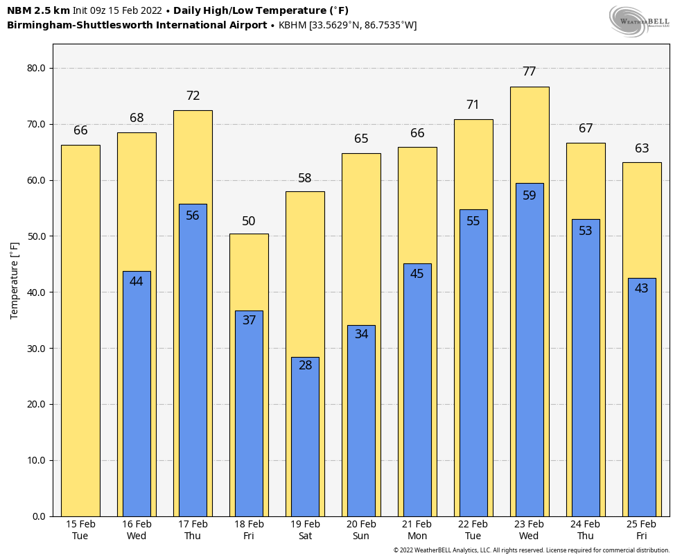
BIG WARM-UP TODAY: Temperatures were mostly between 25 and 35 degrees across Alabama early this morning; look for a high in the mid 60s today with sunshine in full supply. Wednesday will be partly sunny with a high between 65 and 70 degrees. Clouds will increase Wednesday night.
SEVERE WEATHER POTENTIAL THURSDAY: A dynamic weather system will bring the threat of strong to severe thunderstorms to Alabama Thursday afternoon and evening. The Storm Prediction Center has a slight risk (level 2 out of 5) of severe storms defined for areas west of a line from Athens to Moody to Prattville to Jackson; the rest of the state is in a marginal risk (level 1 of 5).
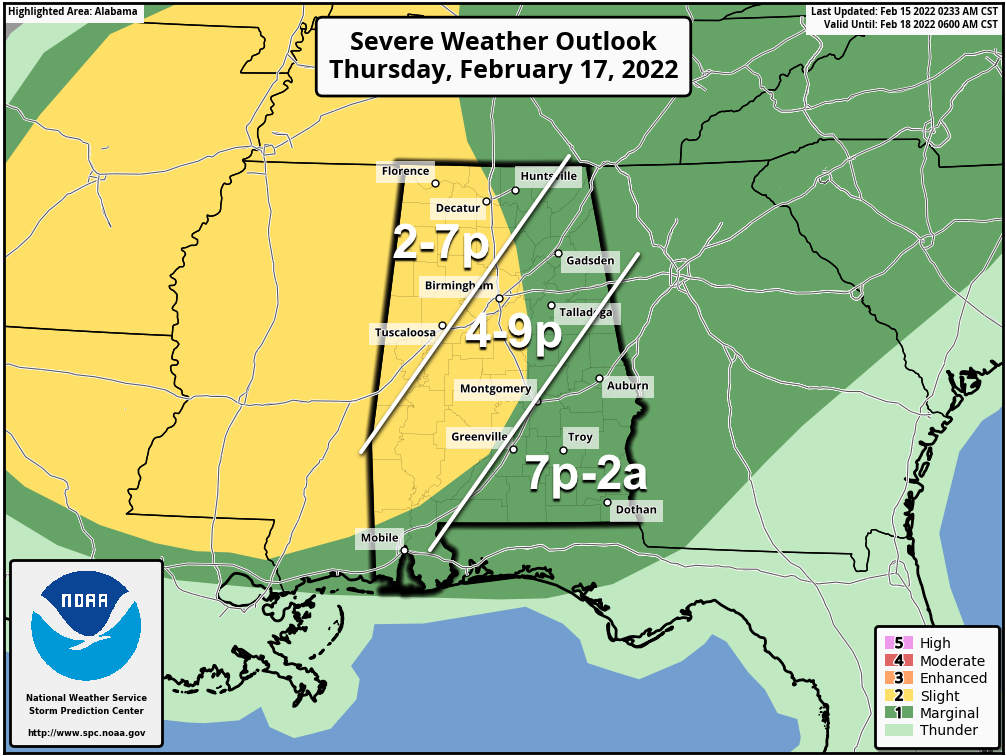
TIMING: The broad window for severe storms in Alabama will come from 2 p.m. until 2 a.m. Storms will end from west to east Thursday night.
THREATS: Storms will be capable of producing hail, strong winds and a few tornadoes. The higher risk of a tornado is over the slight risk across the western half of Alabama.
WIND: Gradient winds (not related to thunderstorms) will average 15-25 mph out of the south, with potential for gusts to 30-35 mph. It will be a windy day.
RAIN: Rain amounts of around 1 inch are likely; a few spots could see higher totals. Flooding is not expected to be an issue for now.
Events like this are common in Alabama in February; tornado season here runs from November through May. Be sure you have a reliable way of hearing warnings if they are needed (never an outdoor siren), and have a plan in case you fall in a tornado warning polygon.
FRIDAY AND THE WEEKEND: The sky becomes partly to mostly sunny Friday, but the day will be sharply colder, with a high around 50 degrees. Dry weather continues over the weekend with sunny days, fair nights and a warming trend. The high will be in the mid to upper 50s Saturday, and then in the mid 60s Sunday.
NEXT WEEK: Moisture returns Monday, and we will bring in the chance of showers. It looks like there will be some risk of rain each day next week with a moist air mass over the state. It’s too early to know whether we will see any severe weather threat. Rain amounts of 1-2 inches look likely Monday through Friday. The week will be mild, as temperatures reach the 70s in many places by Tuesday and Wednesday.
ON THIS DATE IN 2021: Freezing rain continued across parts of north and northwest Alabama. As much as one-half inch of ice accretion occurred in areas, with amounts closer to one-quarter inch more common. The weight of the ice caused trees to bend or fall over and tree branches to break, resulting in power outages. The coating of ice made for dangerous or impossible travel across the warning area. Weak instability aloft yielded a few lightning strikes where frozen precipitation was occurring.
BEACH FORECAST: Click here to see the AlabamaWx Beach Forecast Center page.
WEATHER BRAINS: You can listen to our weekly 90-minute show any time on your favorite podcast app. This is the show all about weather featuring many familiar voices, including the meteorologists at ABC 33/40.
CONNECT: You can find me on the major social networks:
For more weather news and information from James Spann and his team, visit AlabamaWx.


