James Spann: Dry weekend ahead for Alabama, with frost possible Sunday morning
James Spann forecasts a cool, dry weekend for Alabama from Alabama NewsCenter on Vimeo.
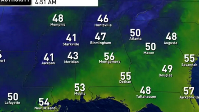
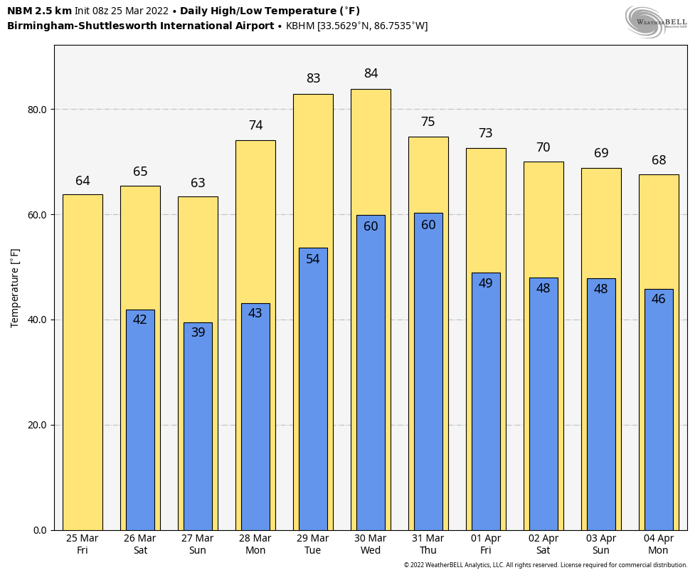
DRY PATTERN CONTINUES: We continue to forecast dry weather through through early next week across Alabama. With a partly sunny sky today we expect a high in the mid 60s. Look for a good supply of sunshine over the weekend; the high will be in the mid 60s Saturday but closer to 60 Sunday. The coldest morning will come early Sunday, with lows in the 30s across about the northern half of Alabama. Frost is likely, and colder spots will see another-late season freeze.
NEXT WEEK: The weather will be warmer. We rise into the low 70s Monday, followed by low to mid 80s Tuesday and Wednesday for a summer preview. A vigorous spring system will bring rain and thunderstorms back to the state Wednesday night into Thursday morning. The Storm Prediction Center has western counties of Alabama in a severe weather risk in its outlook for this event.
For now, it looks like the main window for rain and storms will come from about 6 p.m. Wednesday through 9 a.m. Thursday. Thankfully this will be coming at a time when instability values are low (late night/early morning), but storms still could be strong to severe, with the main threat coming from strong winds. We will be much more specific on this threat over the next few days. Dry air returns to the state Thursday afternoon into Friday.
ON THIS DATE IN 1901: At least 15 people were killed by an estimated F3 tornado that moved across parts of Birmingham. The twister cut a 15-mile path from the south side of the city to Avondale and Irondale.
ON THIS DATE IN 2021: Eleven tornadoes touched down across Alabama; some of them were long track. The most stunning tornado of the event was the long track EF-3 tornado that carved a path of damage spanning 80.38 miles over its 98-minute lifespan from Hale to Shelby counties. This was a single tornado, putting it at No. 7 for the longest single tornado track in Alabama.
Six people were killed by an EF-3 tornado that was down for 38 miles through parts of Calhoun and Cherokee counties. Another EF-3 tornado touched down near West Blocton, and then moved through some highly populated neighborhoods in north Shelby County. Damage was severe in neighborhoods like Eagle Point, Greystone Farms and Shoal Creek. This tornado was down for 50 miles, and there were five injuries.
BEACH FORECAST: Click here to see the AlabamaWx Beach Forecast Center page.
WEATHER BRAINS: You can listen to our weekly 90-minute show any time on your favorite podcast app. This is the show all about weather featuring many familiar voices, including the meteorologists at ABC 33/40.
CONNECT: You can find me on the major social networks:
For more weather news and information from James Spann and his team, visit AlabamaWx.


