Scott Martin: Breezy Saturday for Alabama, with a chilly night ahead
TODAY’S WEATHER: While it will be a beautiful, sunny day, it will be quite breezy at times. Afternoon highs will make it up into the mid 60s to the lower 70s for most across Alabama.

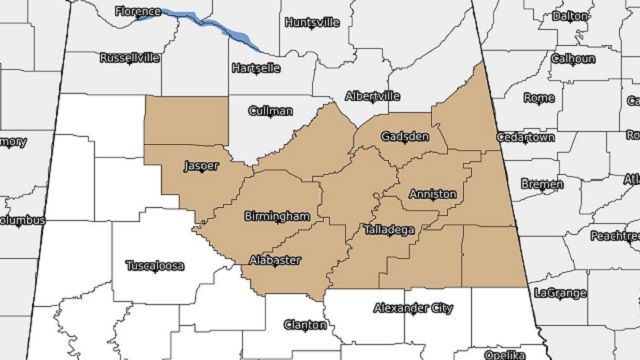
A wind advisory goes into effect today at noon for Blount, Calhoun, Cherokee, Clay, Cleburne, Etowah, Jefferson, Randolph, Shelby, St. Clair, Talladega, Walker and Winston counties in central Alabama. Wind gusts may reach as high as 35 mph out of the west. It is set to expire at 6 p.m.


Tonight will get mighty chilly, and National Weather Service Huntsville has issued a freeze warning for DeKalb, Jackson, Lauderdale, Limestone and Madison counties in north Alabama from 3 a.m. to 9 a.m. Sunday. Lows are expected to drop into the 28- to 32-degree range. A frost advisory is up for Colbert, Cullman, Franklin, Lawrence, Marshall and Morgan counties in north Alabama, and NWS Birmingham has included Blount, Calhoun, Cherokee, Clay, Cleburne, Etowah, Jefferson, Marion, Randolph, Shelby, St. Clair, Talladega, Walker and Winston counties in central Alabama.
SUNDAY’S WEATHER: We’ll have a mix of sun and clouds on Sunday, and after the chilly start we’ll have a nice warm-up, with afternoon highs in the upper 50s to the lower 70s from north to south.
NEXT WEEK: We’ll start warming up on Monday as ridging takes control of our weather pattern. We’ll have mostly sunny skies, with highs in the upper 60s to the upper 70s. Much warmer temperatures can be expected Tuesday as quiet weather continues. Highs will be in the upper 70s to the mid 80s.

On Wednesday, a system will move into the state during the afternoon that will bring rain and thunderstorms, some of which may be strong to severe. The greater chance of the severe storms will be over extreme western Alabama, where a 15% risk has been outlined by the Storm Prediction Center. For now, it is too early to know the exact timing, threats and magnitude, but we’ll have updates leading up to the event. Storms will push through the state overnight and will exit early Thursday. Highs will be in the lower to mid 80s.
That system will be out of here late Thursday morning and we’ll have a good chance to dry out. Skies will become mostly sunny and highs will be in the upper 60s to the lower 80s. Friday will feature sunny skies with highs in the upper 60s to the upper 70s.
For more weather news and information from James Spann, Scott Martin and other members of the James Spann team, visit AlabamaWx.


