James Spann: Significant severe weather threat for Alabama Wednesday night
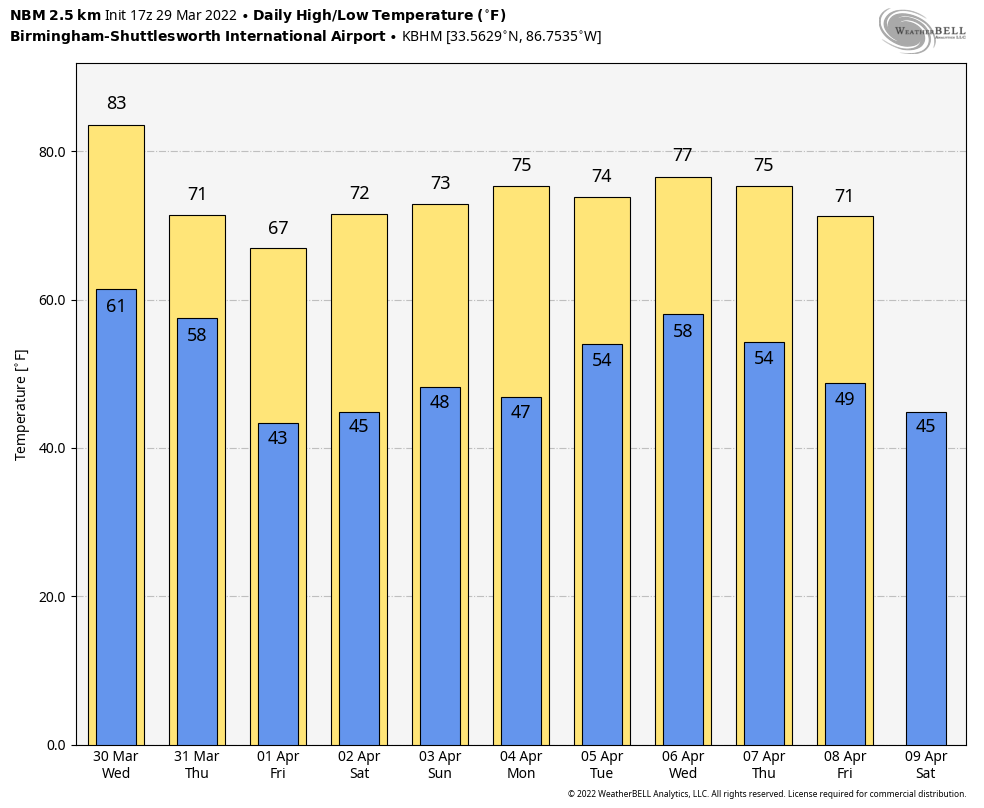
PLEASANT AFTERNOON: The weather is dry across Alabama this afternoon with a partly sunny sky; temperatures are mostly between 75 and 83 degrees. The sky will stay mostly fair tonight with a low in the 50s, but eyes will be to the west, where storms will form in a zone from Texas to Iowa ahead of a dynamic storm system that will bring potential for a significant wind event to the state Wednesday night.
This weather system has very strong wind fields, which will overcome limited instability to create a severe weather threat to the Deep South. The Storm Prediction Center has expanded the moderate risk area (level 4 of 5) to include areas west of a line from Florence to Birmingham to Greenville to Andalusia. The rest of the state is in an enhanced risk (level 3 of 5).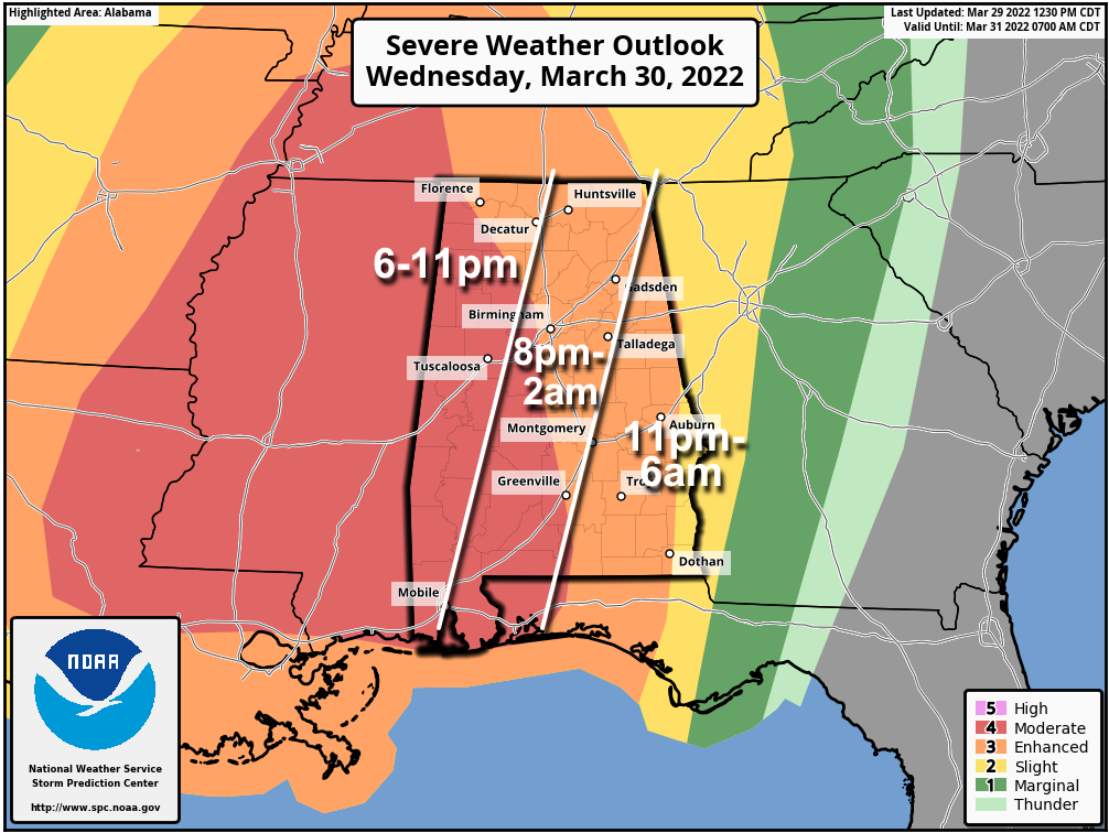 TIMING: A line of severe storms will likely push into the northwest corner of the state around 6-7 p.m. It will be near I-59 (Gadsden, Birmingham and Tuscaloosa) by around 11 p.m. and then moves into the rest of east Alabama after midnight.
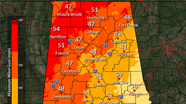
THREATS: There is potential for relatively widespread wind damage with the line of storms as it passes through, with winds possibly gusting to 65 mph or higher in many places. Also, a few tornadoes could spin up within the line. Some hail is possible, but that isn’t a major threat with this type of system.
GRADIENT WIND: It is important to note that gradient winds (not related to thunderstorms) Wednesday afternoon and evening could gust as high as 40-50 mph. This in itself will bring potential for some downed trees and power outages.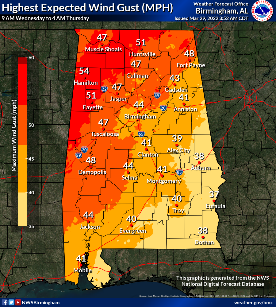
RAIN: Amounts of 1-2 inches are likely for most places, and some flooding is possible. We don’t expect as much rain as we experienced last week, however (some places saw up to 5 inches with that event).
CALL TO ACTION: This has potential to be a high-end wind event for much of Alabama; plan for power outages. Secure loose objects that might go flying away with strong winds. Pay close attention to severe thunderstorm warnings Wednesday night; if you live in a mobile home I would consider treating a severe thunderstorm warning like a tornado warning and be in a community shelter or business that is open and available as a shelter. Be sure you have two reliable ways of hearing warnings (never a siren) — a NOAA Weather Radio and your phone — and be sure emergency alerts are enabled on your phone. Have the free ABC 33/40 weather app installed.
The sky will clear during the day Thursday as dry air returns to the state; the high will be around 70 degrees.
FRIDAY AND THE WEEKEND: Look for mostly sunny days and fair nights Friday through Sunday. The highs will be in the upper 60s Friday and mostly in the low to mid 70s over the weekend. There will be a chance of showers near the Gulf Coast Saturday as a disturbance moves through the northern Gulf, but most of the state will be dry.
NEXT WEEK: Monday will be dry and mild, but rain and storms will return to the state Tuesday. There is evidence that strong to severe storms are possible with this system, but it is way too early to be specific. The latter half of the week looks dry for now.
ON THIS DATE IN 1942: A slow-moving low-pressure system brought 11.5 inches of snow to the nation’s capital. It still stands as the highest March snowfall on record in Washington, D.C., on a single calendar day. Baltimore, Maryland, recorded an imposing total of 21.9 inches of snow on the same day. On the flip side, eight days later, the temperature in D.C. soared to 92 degrees on April 6, 1942, and it remains the highest temperature on record for April 6.
ON THIS DATE IN 1991: A short-lived F1 tornado struck Munford, where it destroyed several mobile homes, killing five people, four of them in one family.
BEACH FORECAST: Click here to see the AlabamaWx Beach Forecast Center page.
WEATHER BRAINS: You can listen to our weekly 90-minute show any time on your favorite podcast app. This is the show all about weather featuring many familiar voices, including the meteorologists at ABC 33/40.
CONNECT: You can find me on the major social networks:
For more weather news and information from James Spann and his team, visit AlabamaWx.


