Scott Martin: Seasonal weekend for Alabama; severe threat Tuesday, Wednesday
THE ALABAMA WEEKEND: A trough with an associated cold front will move across the state today, bringing increased clouds during the morning, but skies will become sunny during the afternoon. There might be just enough moisture to squeeze out a few light showers with those clouds, but most locations will stay dry. Highs will be in the mid 60s to the upper 70s from north to south.
Sunday will be much brighter as drier air moves over Alabama. That will keep clouds out of our skies, and highs will top out in the mid 60s to the mid 70s.
THE CALM BEFORE THE STORMS: While we stay dry Monday, winds will shift out of the southeast to south, allowing humidity levels to start to rise. Skies will be mostly sunny, with highs warming into the lower 70s to the lower 80s. A warm front will move rapidly northward during the late night and overnight, raising humidity values even higher, and a few showers and some thunder may be possible over extreme southern Alabama before sunrise.
RISK OF SEVERE STORMS TUESDAY AND WEDNESDAY: A shortwave will move into Alabama Tuesday, bringing rain and thunderstorms during the morning. The activity will mostly move out by late afternoon, and just enough instability may form with any sunshine to bring a risk of isolated strong to severe storms for the remainder of the afternoon into the evening.
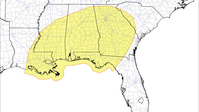
The Storm Prediction Center has a 15% probability for severe storms (slight risk) on Tuesday for most of Alabama, except for the extreme northern and northwestern parts of the state. Rain will be heavy during the morning, and a few minor flash flooding issues may occur. There will be plenty of shear available, so for now it looks like a tornado or two may be possible during the afternoon and evening. Highs will range from the lower 70s in the north to the upper 70s in the south.
The atmosphere will become more unstable Wednesday ahead of a cold front that will push into the state. We’ll have enough shear with the higher instability to have a threat of severe thunderstorms with the potential for damaging winds and large hail. At this point, tornadoes are not favorable but cannot be completely ruled out.
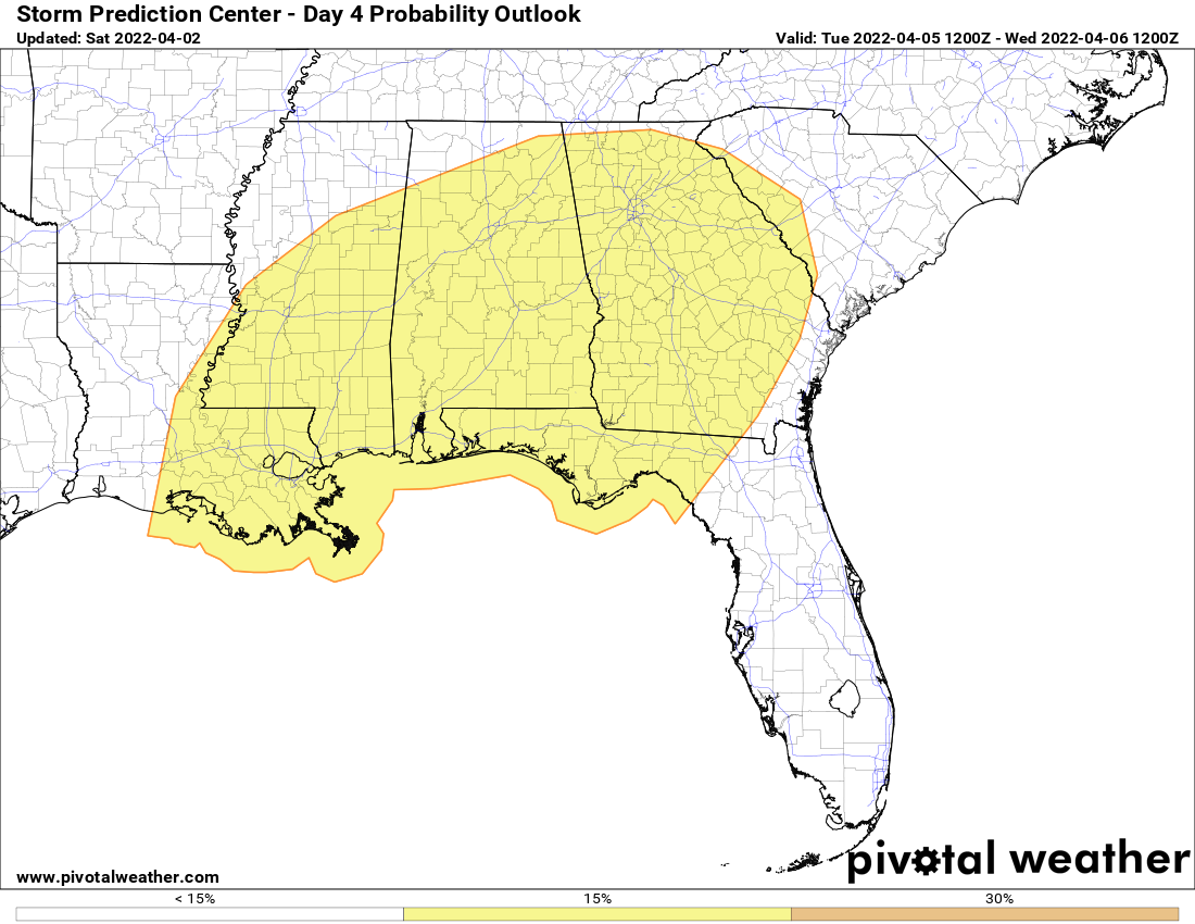
The 15% probability for severe storms is up on Wednesday for all of north and central Alabama except for the northwestern corner. This activity looks to occur during the afternoon and evening, and will be completely out of the state after midnight. Highs will be in the upper 70s to the mid 80s.
END OF THE WORK WEEK: A good bit of sunshine and drier weather returns Thursday. Highs will be in the mid 60s to the mid 70s. Friday will be mainly sunny with cooler temperatures — highs in the upper 50s to the upper 60s.
ON THIS DATE IN 2006: Tornadoes and hail as big as softballs ripped through eight Midwestern states, killing at least 27 people, injuring scores and destroying hundreds of homes. In Tennessee, tornadoes killed 23 people, including an infant and a family of four. Severe thunderstorms, many producing tornadoes, also struck parts of Iowa, Kentucky, Arkansas, Missouri, Ohio, Illinois and Indiana. Strong wind was blamed for at least three deaths in Missouri. The Storm Prediction Center in Norman, Oklahoma, said it had preliminary reports of 63 tornadoes. The worst damage occurred throughout the Tennessee Valley.
BEACH FORECAST: Get the latest weather and rip current forecasts for the beaches from Dauphin Island to Panama City Beach, Florida, on our Beach Forecast Center page. There, you can select the forecast of the region you are interested in.
For more weather news and information from James Spann, Scott Martin and other members of the James Spann team, visit AlabamaWx.


