James Spann: Windy, colder in Alabama Friday, with a few showers
PLEASANT SPRING DAY: With a good supply of sunshine, temperatures are in the 60s over the northern half of Alabama this afternoon, with 70s for the southern counties. The sky will stay mostly fair tonight with a low not too far from 40 degrees.
 Friday will be windy and noticeably cooler; the sky will be occasionally cloudy, and a few spotty showers will form over the northern third of the state under a deep upper trough. Rain amounts will be light and spotty, and temperatures won’t get out of the 50s across most of north Alabama. A west wind of 12-25 mph will make it feel colder.
FREEZE/FROST THREAT: We are still forecasting lows well down in the 30s Saturday and Sunday mornings with frost likely over the northern half of the state. Colder pockets will dip into the 26- to 32-degree range; growers will need to monitor temperature forecasts for their specific communities. On the positive side, look for lots of sun over the weekend; the high will be around 60 Saturday, followed by low to mid 70s Sunday as a warming trend begins.
NEXT WEEK: Moisture levels will be on the rise Monday and a few showers will likely form. We will mention a chance of scattered showers and thunderstorms Tuesday and Wednesday; then an organized band of storms will arrive late Wednesday night or Thursday morning. It’s too early to know whether severe storms will be an issue here; the Storm Prediction Center does have risks highlighted for areas west of Alabama Monday through Wednesday.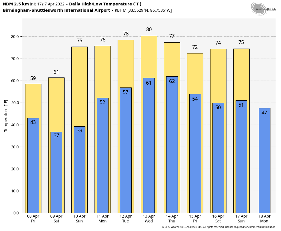 RAIN UPDATE: Here are rain totals since the first of the year, and the departure from average:
- Huntsville — 23.88 inches (7.41 inches above average)
- Birmingham — 23.86 (7.16 above average)
- Tuscaloosa — 20.97 (4.81 above average)
- Muscle Shoals — 20.87 (5.23 above average)
- Anniston — 19.5 (3.26 above average)
- Montgomery — 17.59 (1.98 above average)
- Mobile — 13.31 (3.41 below average)
- Dothan — 13.29 (2.05 below average)
ON THIS DATE IN 1980: Severe thunderstorms spawned tornadoes that ripped through central Arkansas. The storms also produced high winds and baseball-sized hail. Five counties were declared disaster areas by President Jimmy Carter. A tornado causing F3 damage also affected St. Louis and St. Charles counties in Missouri, producing $2.5 million in damage.
BEACH FORECAST: Click here to see the AlabamaWx Beach Forecast Center page.
WEATHER BRAINS: You can listen to our weekly 90-minute show any time on your favorite podcast app. This is the show all about weather featuring many familiar voices, including the meteorologists at ABC 33/40.
CONNECT: You can find me on the major social networks:
For more weather news and information from James Spann and his team, visit AlabamaWx.


