James Spann: Much cooler in Alabama today; clearing this afternoon
James Spann forecasts a brief cooldown for Alabama from Alabama NewsCenter on Vimeo.
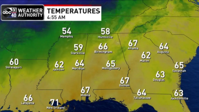
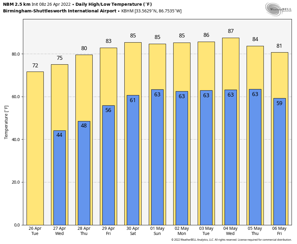
RADAR CHECK: A band of showers in association with a cold front is working through the state early this morning; these showers should be out of the northern half of the state by midmorning, and we expect a clearing sky this afternoon. Showers could linger over the southeast counties during the afternoon, but rain amounts there will be very light and spotty. Today will be much cooler, with a high between 68 and 72 degrees; the average high for Birmingham on April 26 is 78.
Tonight will be clear and very cool; most places will drop into the 40- to 45-degree range early Wednesday. Not many more of these cool mornings left before the long, hot summer gets here.
Expect sunny days, fair nights and a warming trend Wednesday for the rest of the week. The high will be in the mid 70s Wednesday, close to 80 Thursday and in the low 80s Friday.
THE ALABAMA WEEKEND: While moisture levels will slowly rise over the weekend, an upper ridge stays in place across the Deep South, and that should keep the weather generally dry. We will forecast a partly sunny sky Saturday, and on Sunday a few spotty showers could show up over the northern half of the state, but many places will stay rain-free. Odds of any one spot getting a shower are around 10% Saturday and 15-20% Sunday. Highs will be in the mid 80s over the weekend under the ridge.
NEXT WEEK: The weather looks quiet much of the week with warm days; we will mention a chance of showers Thursday as a front sags into the state, but rain amounts probably won’t be too heavy with the ridge in place. Highs will be in the 80s, and there’s still no sign of any severe weather for the state for the next seven to 10 days.
ON THIS DATE IN 1978: An unusually strong occluded front swept out of the Gulf of Alaska and produced the first April thunderstorm of record at Fairbanks. Pea-sized hail fell northeast of Fairbanks from thunderstorms whose tops were less than 8,000 feet.
ON THIS DATE IN 2011: The generational tornado outbreak of late April 2011 was underway. A high risk of severe weather was issued for April 26 for portions of Louisiana, Arkansas, Oklahoma and Texas along and near the Interstate 30 corridor as conditions became even more favorable for extreme weather. Numerous tornadoes touched down across several states, including Texas, Louisiana and Arkansas. Most of those tornadoes were weak, but a few of them caused considerable damage. A long-tracked wedge tornado caused EF-2 damage in rural portions of Texas and Louisiana. An EF-3 tornado destroyed structures and caused severe damage at Fort Campbell, Kentucky, as well. A total of 55 tornadoes were confirmed on the 26th, although no fatalities occurred.
The following day, April 27, 62 tornadoes would touch down across Alabama, killing 252 people.
BEACH FORECAST: Click here to see the AlabamaWx Beach Forecast Center page.
WEATHER BRAINS: You can listen to our weekly 90-minute show any time on your favorite podcast app. This is the show all about weather featuring many familiar voices, including the meteorologists at ABC 33/40.
CONNECT: You can find me on the major social networks:
For more weather news and information from James Spann and his team, visit AlabamaWx.


