James Spann: Scattered strong to severe storms form in Alabama today
James Spann has the midweek forecast for Alabama from Alabama NewsCenter on Vimeo.
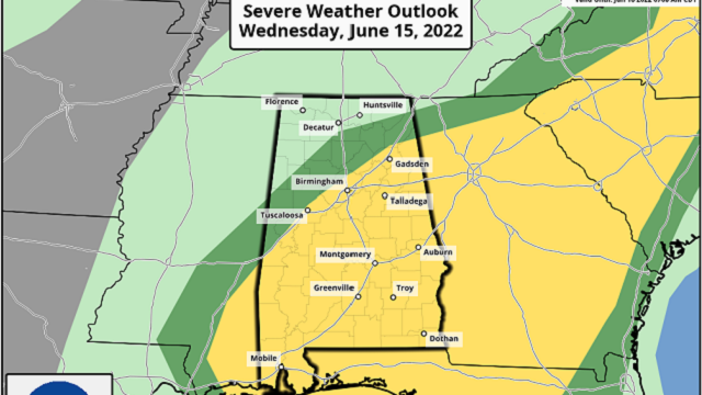
SCATTERED STORMS LATER TODAY: The sky is mostly fair across Alabama early this morning with temperatures in the 70s; we rise into the 90s again today with a partly sunny sky. During the heat of the day, random, scattered storms will likely form over the southern two-thirds of the state, and those could pack a punch. The Storm Prediction Center maintains a slight risk (level 2 out of 5) of severe thunderstorms today mainly for areas south of I-59.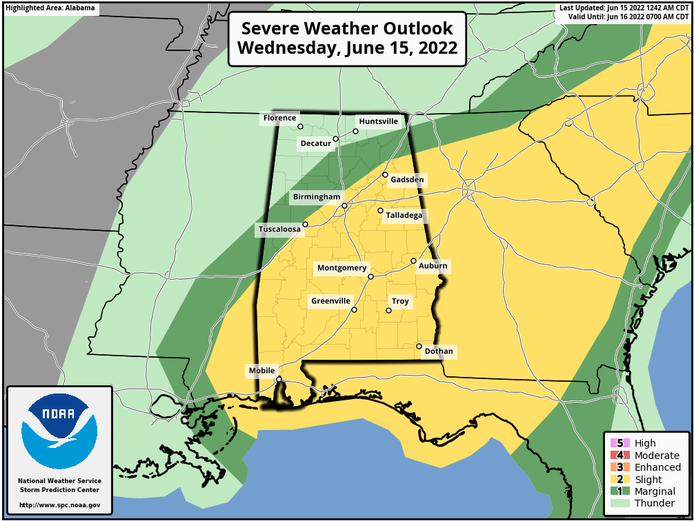 The main threat from heavier storms will come from strong straight-line winds. Of course, all summer storms produce a large amount of cloud-to-ground lightning and are efficient rain producers. It won’t rain everywhere today; odds of any one spot seeing a storm are 30-40% south of I-59 and 10-20% over the northern third of the state.
THURSDAY THROUGH THE WEEKEND: We will keep some risk of isolated afternoon and evening storms in the forecast Thursday and Friday, but most places will be hot and dry, with highs in the mid 90s. A drier air mass drops into the state Friday night, and the weekend will feature sunny days, lower humidity levels and cooler nights. Some of the cooler spots across north Alabama could reach the 50s early Sunday morning; highs will be mostly in the low 90s.
NEXT WEEK: Moisture levels creep up again and heat levels remain elevated. Highs will be mostly in the 90s, lows in the 70s, and any afternoon and evening showers and thunderstorms should remain fairly scarce under the upper high. Temperatures will likely remain above average through the rest of June.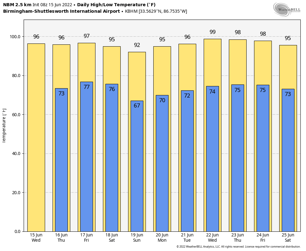 TROPICS: Satellite imagery and surface observations indicate a small area of low pressure over the far southwestern Caribbean Sea near the east coast of Nicaragua. This system is accompanied by disorganized showers and thunderstorms. Development is possible while the system drifts northwestward near the coasts of Nicaragua and Honduras, and it could become a tropical depression later this week if the disturbance remains over water. An Air Force Reserve Hurricane Hunter aircraft is scheduled to investigate the system later today if necessary. Regardless of development, the low could produce periods of heavy rainfall across portions of eastern Nicaragua and eastern Honduras through late this week.
The National Hurricane Center gives the system a 40% chance of developing over the next five days. If anything does form here, it will stay far south of the north central Gulf Coast (places like Gulf Shores, Destin and Panama City Beach). The rest of the Atlantic basin is very quiet.
HEAT PARADE: Here are some highs across Alabama Tuesday:
- Moody — 92
- Oneonta — 93
- Alabaster — 93
- Heflin — 93
- Morris — 93
- Gadsden — 94
- Thorsby — 95
- Anniston — 95
- Decatur — 95
- Carbon Hill — 95
- Rainbow City — 95
- Birmingham (Oxmoor Valley) — 95
- Huntsville — 96
- Muscle Shoals — 96
- Crestwood — 96
- Cottondale — 96
- Coker — 96
- Calera — 97
- Selma — 97
- Mobile — 98
- Tuscaloosa — 98
- Troy — 98
- Montgomery — 99
ON THIS DATE IN 1991: The second-largest volcanic eruption of the 20th century began as Mount Pinatubo injected 15 to 30 million tons of sulfur dioxide 100,000 feet into the atmosphere. As a result of the eruptions, 343 people were killed in the Philippines and 200,000 were left homeless. Material from the explosion would spread around the globe, leading to climate changes worldwide as the sun’s energy was blocked out and global temperatures cooled by as much as one degree Fahrenheit. The next year, 1992, was globally one of the coldest since the 1970s.
BEACH FORECAST: Click here to see the AlabamaWx Beach Forecast Center page.
WEATHER BRAINS: You can listen to our weekly show all about weather any time on your favorite podcast app. James Spann and a team of meteorologists from around the nation bring on interesting guests; it’s a great podcast for weather geeks.
For more weather news and information from James Spann and his team, visit AlabamaWx.


