James Spann: Summer mix of sun, scattered storms for Alabama
James Spann forecasts little change in Alabama’s weather from Alabama NewsCenter on Vimeo.
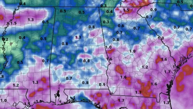
SUN AND STORMS: A weak surface front is stalled across Alabama this morning, not too far from I-20. This means most of the showers and storms today, like Monday, will be over the southern two-thirds of the state, but an isolated shower can’t be ruled out over north Alabama as well this afternoon. Odds of any one spot getting wet today are 35-45% along and south of I-20, and 15-25% north of I-20 (over the northern third of the state). Otherwise, expect a mix of sun and clouds with a high between 86 and 89 degrees for most places. The average high for June 20 in Birmingham is 90.
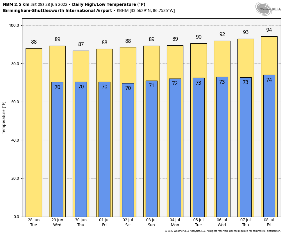
The weather won’t change much over the rest of the week as the weak surface front dissipates and we stay in a very humid air mass. Days will be partly sunny and humid with scattered, mostly afternoon and evening showers and thunderstorms. Summer storms are random; there is no way of knowing in advance exactly when and where they pop up, and who gets the rain, but any given community will have a good chance of seeing at least one or two downpours between now and Friday. Highs will remain in the upper 80s most days.
FOURTH OF JULY WEEKEND: Look for a classic summer mix of sun and scattered thunderstorms Saturday through Monday with highs in the upper 80s. Most of the storms will come from about 2 until 10 p.m., and the chance of any one spot getting wet each day is 45-55%. There is a chance some deeper tropical moisture could move into the state from the west (the tropical wave now in the western Gulf); if that happens rain coverage will be higher each day. But, one way or another, the weekend won’t be a washout. You will have the chance of a shower or storm just about every day in summer in Alabama. It is just that time of the year.
REST OF NEXT WEEK: We will stick with a persistence forecast — partly sunny days, a few showers and storms during the afternoons and evenings, and highs back in the low 90s.
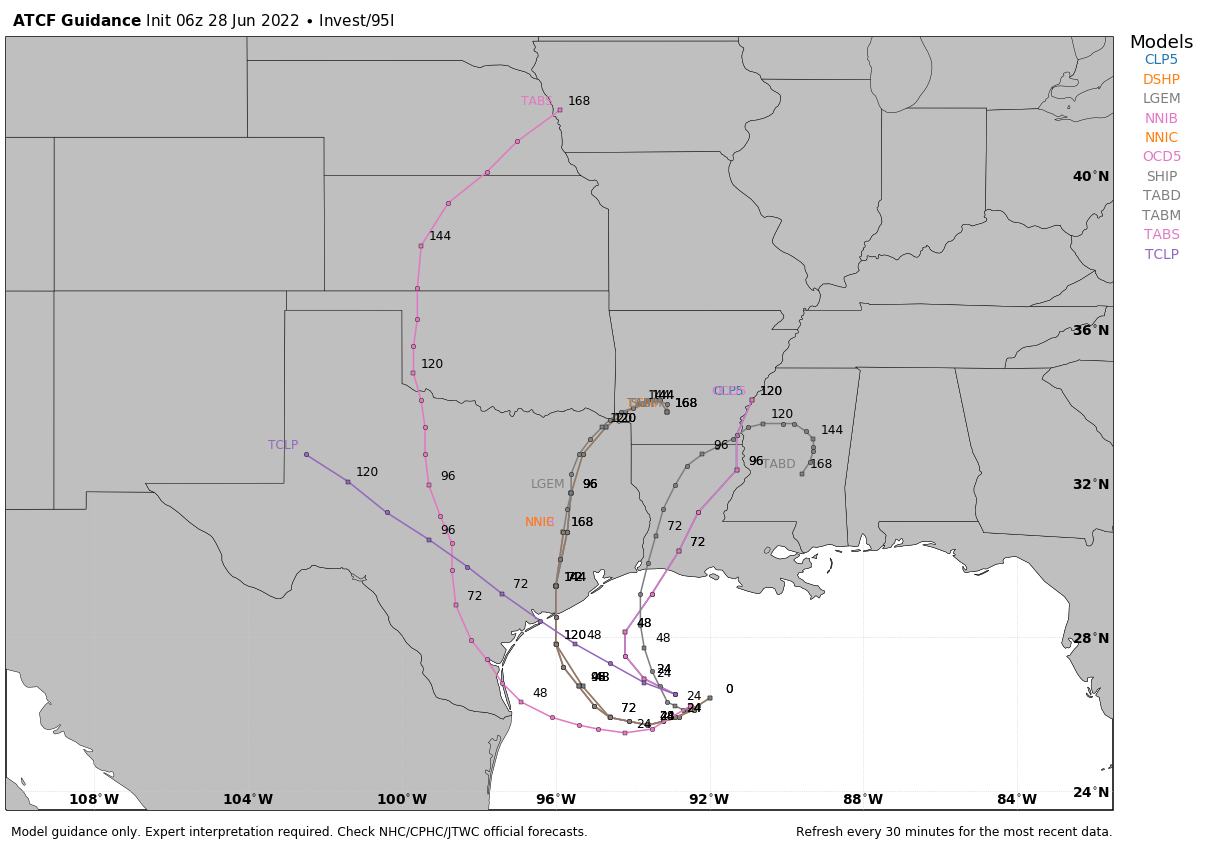
TROPICS: A surface trough of low pressure is over the north-central Gulf of Mexico. While shower and thunderstorm activity with this system is currently limited, surface pressures have fallen some over the last 24 hours. Some additional development is possible as the system moves generally westward at 5-10 mph and approaches the coast of Texas. The National Hurricane Center gives it a 30% chance of development over the next few days; one way or another it will likely enhance the chance of rain for parts of east and south Texas later this week.
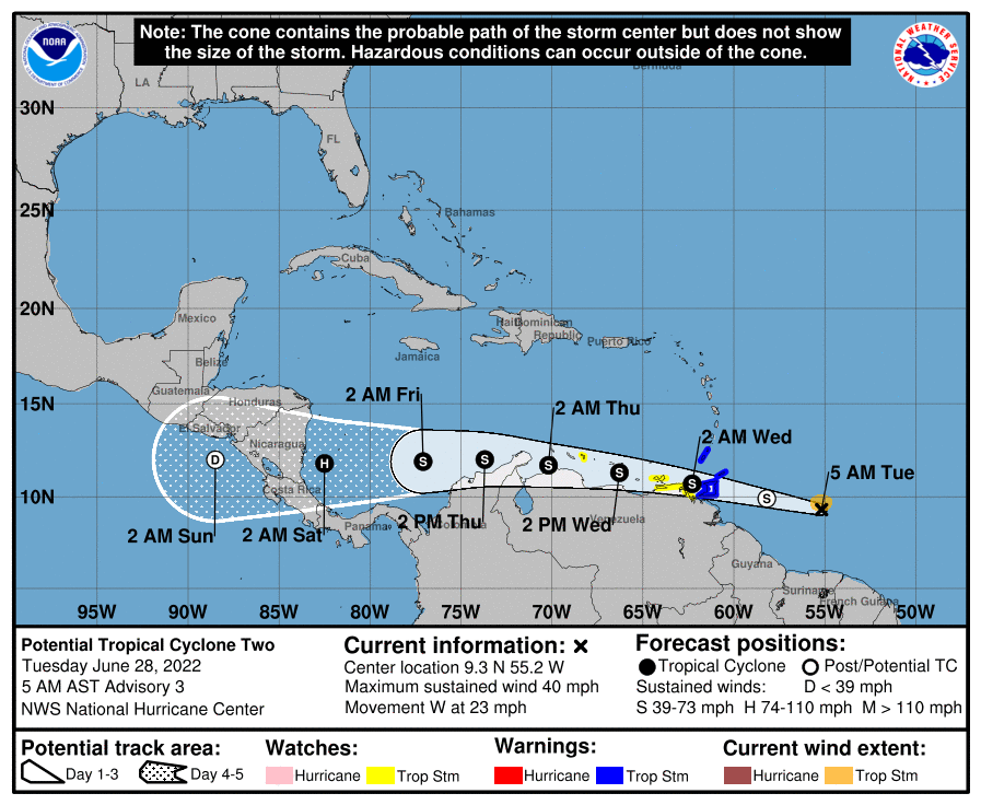
In the Atlantic, Potential Tropical Cyclone 2 is expected to become a depression or storm later today as it moves through the Windward Islands. This feature will skirt the northern coast of South America as it remains at a very low latitude, and is forecast to make landfall on the coast of either Costa Rica or Nicaragua Saturday morning, possibly as a hurricane. This is far south of the U.S.
ON THIS DATE IN 1924: An estimated F4 tornado struck the Ohio towns of Sandusky and Lorain, killing 85 people and injuring more than 300. This tornado is the deadliest ever in Ohio history.
ON THIS DATE IN 1975: Lightning struck Lee Trevino and two other golfers at the Western Open golf tournament in Oak Brook, Illinois.
BEACH FORECAST: Click here to see the AlabamaWx Beach Forecast Center page.
For more weather news and information from James Spann and his team, visit AlabamaWx.


