Scott Martin: Rain creeps into Alabama late today; strong to severe storms possible Sunday
THE ALABAMA WEEKEND: Today will start off with mostly sunny skies, but through the afternoon clouds will begin to increase from the west with a cold front pushing in our direction. Showers will start to move into the state by late afternoon and through the evening and nighttime. The highest rain chances will be along and north of the I-20 corridor. Highs will be in the lower 60s to the lower 70s.
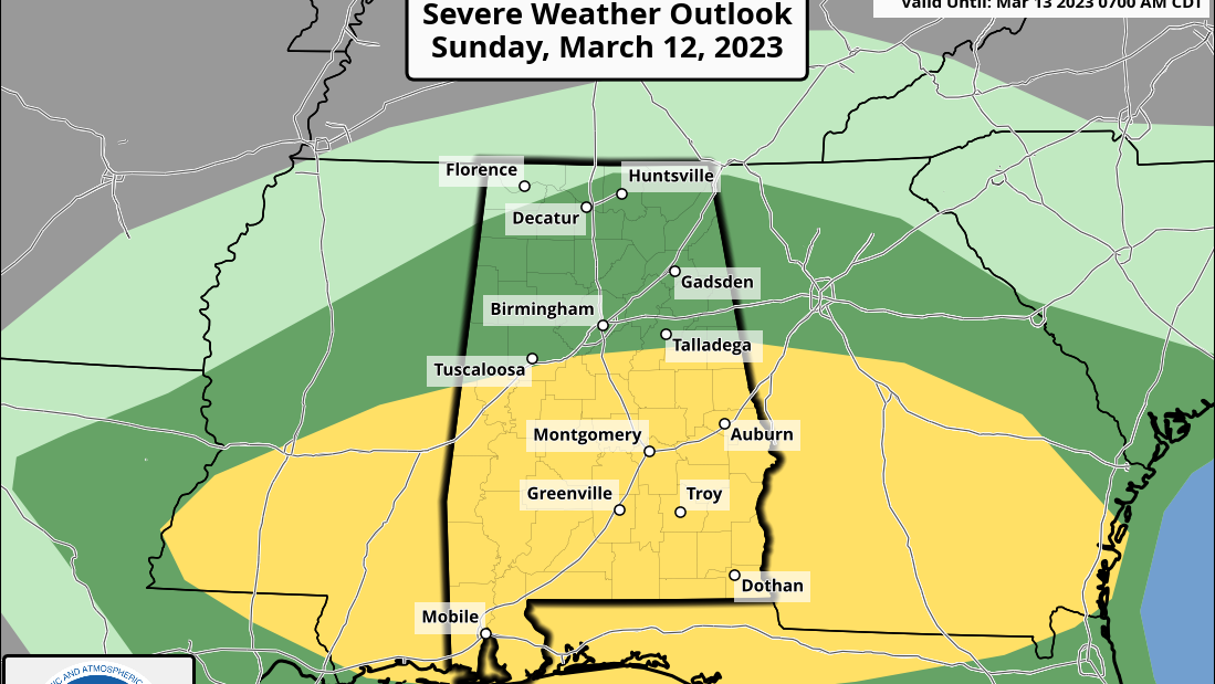
Sunday will start off with rain and thunderstorms across a good bit of Alabama as the cold front begins to make its way into and eventually through the state. Storms during the afternoon and evening may pack a punch with damaging winds and hail. The Storm Prediction Center has a slight risk (level 2 of 5) up for locations south of a line from just north of Geiger to Alabaster to just north of Wedowee, while nearly the rest of the state north of this is in a marginal risk (level 1). The main severe threat window will be from noon in the northwest and coming to an end around 7 p.m. in the southeast. Highs will be in the lower 60s to the mid 70s.
NEXT WEEK: Cooler, drier air will be the story for the first half of next week after the cold front moves through. Monday will be sunny and breezy, with highs in the lower 50s to the mid 60s. Tuesday will start off chilly, with widespread frost possible, but we’ll see sunny skies and highs in the lower 50s to the lower 60s. Same story on Wednesday morning, with frost possible, but ridging starts to move in, warming our highs into the upper 50s to the upper 60s.
Warm-air advection continues to pull in warmer air from the south as we see our next system head in our direction on Thursday. Skies will be sunny during the daylight, with clouds increasing late. Highs will be in the upper 60s to the mid 70s.
On Friday a cold front will move into and through the state, bringing rain and maybe a clap of thunder or two, but at this point instability rates look very low and strong storms do not look possible. Highs will be in the lower 60s to the upper 70s.
For more weather news and information from James Spann, Scott Martin and other members of the James Spann team, visit AlabamaWx.


