James Spann: Wet day for Alabama with falling temperatures
James Spann forecasts a rainy, cooler day for Alabama from Alabama News Center on Vimeo.
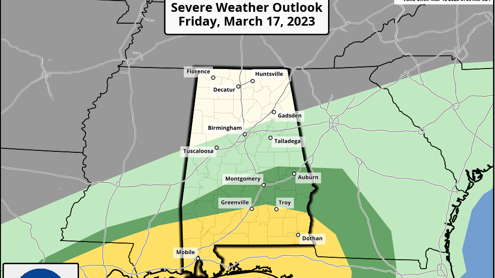
RADAR CHECK: Rain is widespread over the northern half of Alabama early this morning; that rain will shift southward during the day ahead of a cold front. The Storm Prediction Center maintains a slight risk (level 2 out of 5) of severe thunderstorms for the southern quarter of Alabama today, south of a line from Grove Hill to Greenville to Troy. A marginal risk (level 1) extends as far north as Sweetwater, Prattville and Opelika.
This is a fairly low-end severe weather threat for south Alabama, but a few storms ahead of the cold front could produce strong, gusty winds. An isolated tornado can’t be ruled out but isn’t likely. Rain amounts for most places in the state today will be in the one-half-inch to 1-inch range.
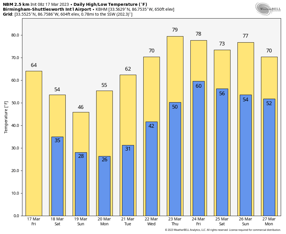
Temperatures will fall quickly across the northern and central counties of the state after the surface front passes. Many places will fall from the low 60s this morning into the 40s by mid to late afternoon with a chilly north wind. Rain will end from the northwest as the cold air rushes in.
THE ALABAMA WEEKEND: Temperatures will be well below average. Some north Alabama communities could reach the freezing mark early Saturday morning, but a freeze is likely early Sunday over the northern half of the state, with lows mostly in the 20s. Frost is likely deep into south Alabama. With a mix of sun and clouds, expect a high in the 50s Saturday, and on Sunday areas north of I-20 won’t get out of the 40s despite a sunny sky.
NEXT WEEK: Monday morning will be cold again, with lows in the 20s over the northern half of the state, and some places across north Alabama could see yet another freeze early Tuesday. Then a warming trend begins, and by Thursday afternoon the high will be near 80 degrees. The weather will be dry Monday through Thursday with mostly sunny days and fair nights; showers return Friday.
 ON THIS DATE IN 1990: Showers and thunderstorms associated with a slow-moving cold front produced torrential rains across parts of the southeastern U.S. over two days. Flooding claimed the lives of at least 22 people, including 13 in Alabama. Up to 16 inches of rain deluged southern Alabama, with 10.63 inches reported at Mobile in 24 hours. The town of Elba was flooded with 6 to 12 feet of water, causing more than $25 million damage, and total flood damage across Alabama exceeded $100 million.
ON THIS DATE IN 2021: Severe thunderstorms produced 25 tornadoes across Alabama. The longest-track tornado was around 36.5 miles, from Wayne County, Mississippi, to southern Marengo County, Alabama. Three were injured in Alabama; there were no fatalities.
BEACH FORECAST: Click here to see the AlabamaWx Beach Forecast Center page.
For more weather news and information from James Spann and his team, visit AlabamaWx.


