James Spann: Rain, a few strong storms for Alabama Thursday
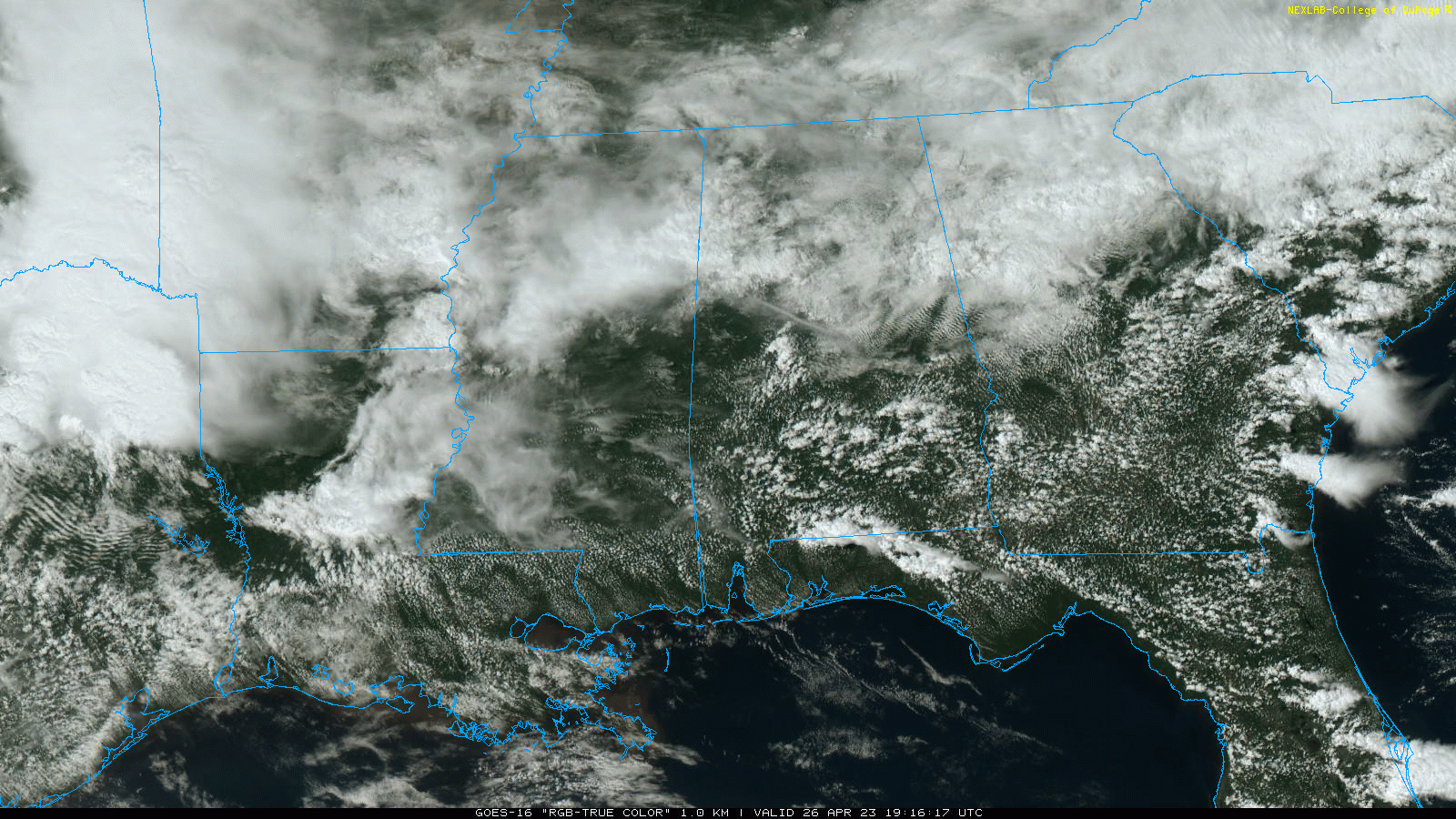
RADAR CHECK: We have a few scattered showers across Alabama this afternoon, but the rain is not especially widespread, and the southern counties are seeing a decent amount of sun. Temperatures range from the 60s over north Alabama to the low to mid 80s down south. We will maintain the chance of a few scattered showers and thunderstorms statewide tonight.
 THURSDAY: An organized area of rain and storms will push through the state Thursday, and the Storm Prediction Center has defined a slight risk (level 2 out of 5) of severe thunderstorms for areas south of a line from Grove Hill to Fort Deposit to Phenix City. A marginal risk (level 1) extends northward to the Tennessee state line.
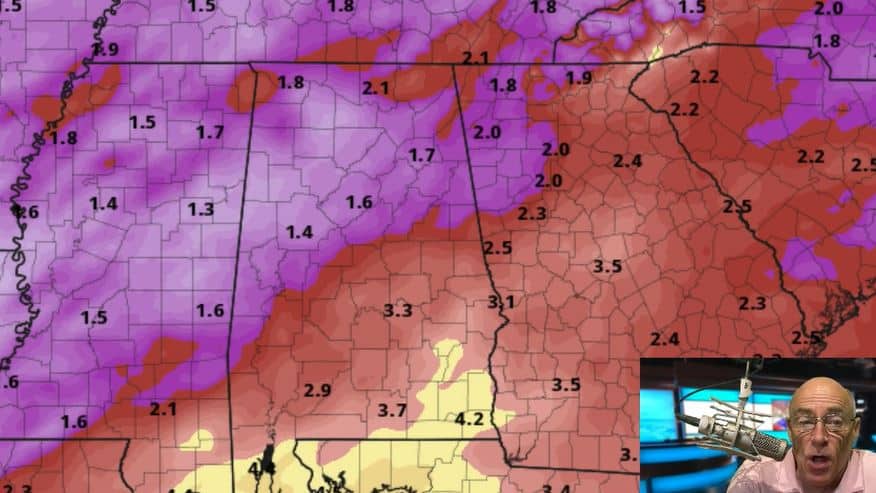
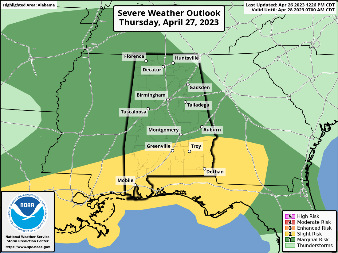 The core threat of heavier storms will be over the southern quarter of the state, where the air will be most unstable. The main threats will come from small hail and strong straight-line winds, but an isolated tornado can’t be ruled out, especially south of U.S. 84. Rain will be heavy at times across south Alabama, where amounts could exceed 1 inch.
The risk of severe thunderstorms over the northern half of the state is low, and there is no tornado threat there. Rain amounts over north Alabama will be generally one-half inch or less.
The core window for rain initially will come from 9 p.m. until 5 p.m. A few additional showers and thunderstorms are possible Thursday night as the upper trough approaches.
FRIDAY AND THE WEEKEND: We will mention the risk of a stray shower Friday morning, but a decent part of the day will be dry with potential for some clearing by afternoon. The high will be in the mid 70s.
We are getting better clarity on the weekend weather situation. Almost all of north and central Alabama will be dry Saturday with a partly sunny sky and a high in the 70s. However, a surface low in the northern Gulf will set up a rainy day for the Gulf Coast.
Some rain is possible statewide Saturday night into Sunday morning, followed by drier air pushing into the state Sunday afternoon. The high will be close to 70 degrees.
NEXT WEEK: Much of next week looks dry at this point with highs mostly in the 70s.
 ON THIS DATE IN 1986: The Chernobyl nuclear power station in Kiev, Ukraine, sustained a massive explosion. The radioactive cloud of particles and gas carried westward and northwestward, contaminating large areas of Europe in the following week.
ON THIS DATE IN 2011: A total of 55 tornadoes touched down across several states, including Texas, Louisiana and Arkansas. Most were weak, but a few caused considerable damage. A long-tracked wedge tornado caused EF-2 damage in rural portions of Texas and Louisiana. It was the beginning of the “Super Outbreak” of tornadoes that would peak on the next day, April 27, 2011.
For more weather news and information from James Spann and his team, visit AlabamaWx.


