James Spann: New day, old forecast for Alabama; sun, storms
James Spann sees more of the same for Alabama’s weather at midweek from Alabama News Center on Vimeo.
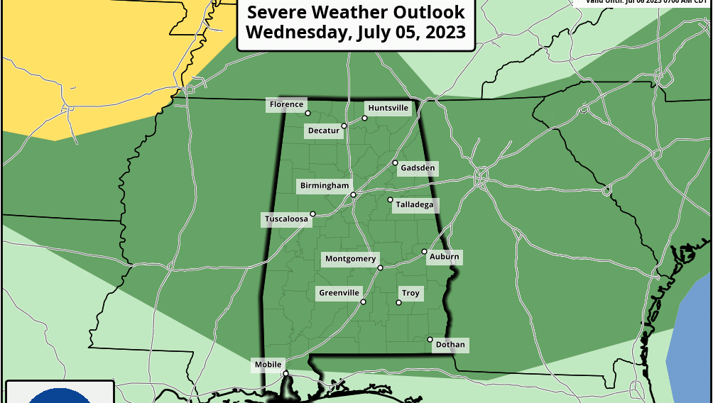
CLASSIC SUMMER WEATHER CONTINUES: Most of Alabama is dry early this morning, with just a few showers southeast of Montgomery and over the eastern half of the Tennessee Valley just before daybreak. Expect a partly sunny sky today with developing showers and thunderstorms in random, scattered spots this afternoon and early tonight. Where storms do form, they will be strong; the Storm Prediction Center has most of the state in a marginal risk (level 1 out of 5) of severe thunderstorms.
Heavier thunderstorms will be capable of producing hail and strong winds. Most of them will come from about 2 until 9 p.m. The chance of any one spot getting rain today is 50-60%, and the high will be close to 90 degrees.
We aren’t expecting much change Thursday and Friday — highs around 90 degrees with afternoon and evening thunderstorms in scattered spots.
THE WEEKEND AND NEXT WEEK: We will stick with a persistence forecast for Saturday, Sunday and next week as our classic summer pattern rolls along. Look for partly sunny days with the risk of mostly afternoon and evening showers and thunderstorms. Afternoon highs will be generally between 89 and 92 degrees, and the chance of any one specific location seeing a storm each afternoon is 50-60%. Most of the showers and thunderstorms will come in the 2 to 9 p.m. window.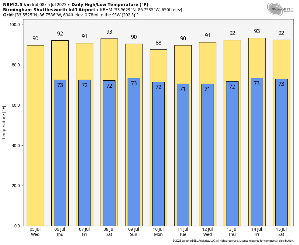 TROPICS: The Atlantic basin remains very quiet, and tropical storm formation is not expected for at least the next seven days.
RAIN UPDATE: Here are rain totals so far this year, and the departure from average:
- Anniston — 32.62 inches (3.57 inches above average)
- Mobile — 32.48 (1.68 below average)
- Tuscaloosa — 30.35 (1.23 above average)
- Birmingham — 29.23 (1.9 below average)
- Dothan — 27.41 (0.47 below average)
- Montgomery — 27.04 (0.32 below average)
- Huntsville — 26.52 (3.23 below average)
- Muscle Shoals — 26.06 (3.67 below average)
ON THIS DATE IN 1916: In the afternoon a Category 3 hurricane struck near Pascagoula, Mississippi. The maximum winds at landfall were 105 knots or approximately 121 mph. This hurricane produced the record-setting surge for the Mobile area of 11.6 feet, with 5 feet measured in Pensacola, Florida, and 6.3 feet measured on Fort Morgan.
ON THIS DATE IN 1937: The temperature at Medicine Lake, Montana, soared to 117 degrees to tie the state record. Glendive, Montana, reached 117 degrees on July 20, 1893.
For more weather news and information from James Spann and his team, visit AlabamaWx.


