James Spann: Sizzling heat returns to Alabama next week
James Spann forecasts a long dry spell for Alabama, with rising heat from Alabama News Center on Vimeo.
DRY SUMMER PATTERN: Alabama’s weather will stay dry through the weekend with mostly sunny days and fair nights. Heat and humidity levels will slowly rise; expect a high near 90 today, followed by mid 90s over the weekend. A brief, isolated storm can’t be ruled out Sunday near the Gulf Coast, but even there most places will stay dry.
It sure looks like next week will be the hottest of the summer for the Deep South. Highs will be between 97 and 101 degrees most days, with lows in the 70s. A strong upper ridge and the associated sinking air will keep most of the state dry. The National Weather Service will be issuing its heat advisories, warnings, etc., for high heat-index values.
The upper ridge will weaken in seven to 10 days, with lower heat levels and the return of scattered showers and thunderstorms.
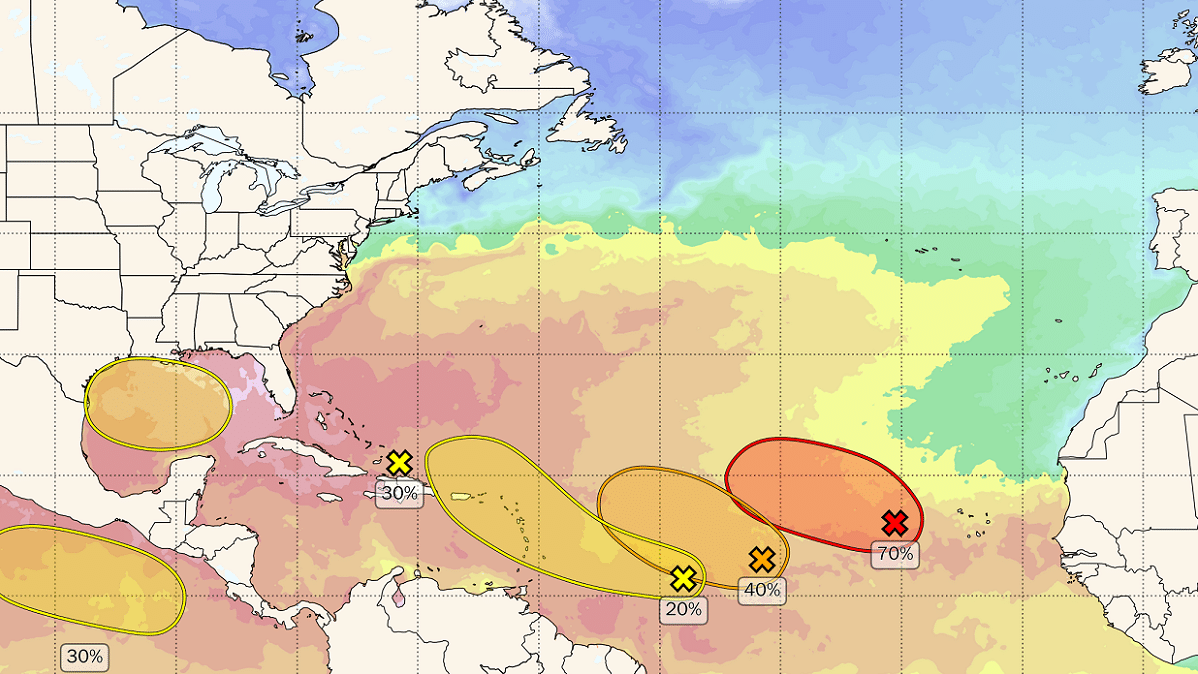
 TROPICS: The National Hurricane Center (NHC) has identified four areas to watch across the Atlantic basin; of those four, only one has a decent chance of development. This is Invest 98L in the eastern Atlantic. It is forecast to turn north over the open Atlantic and most likely will remain far from land.
Closer to home, an area of disturbed weather just north of Hispaniola is forecast by early next week to move into the Gulf of Mexico, where a broad area of low pressure could form. Some slow development of this system is possible thereafter as it moves westward and approaches the Texas coast by the middle of next week. The NHC gives this only a 30% chance of becoming a depression or storm.
There are no tropical systems that will threaten the central Gulf Coast (Gulf Shores to Panama City Beach) over the next seven days.
In the eastern Pacific, Hilary has become a major Category 4 hurricane off the coast of Mexico with sustained winds of 145 mph. It will make landfall on Baja California Sunday, and the tropical moisture plume will move up into the southwest U.S. Sunday and Monday with potential for major flooding across parts of southern California, southern Nevada and far western Arizona.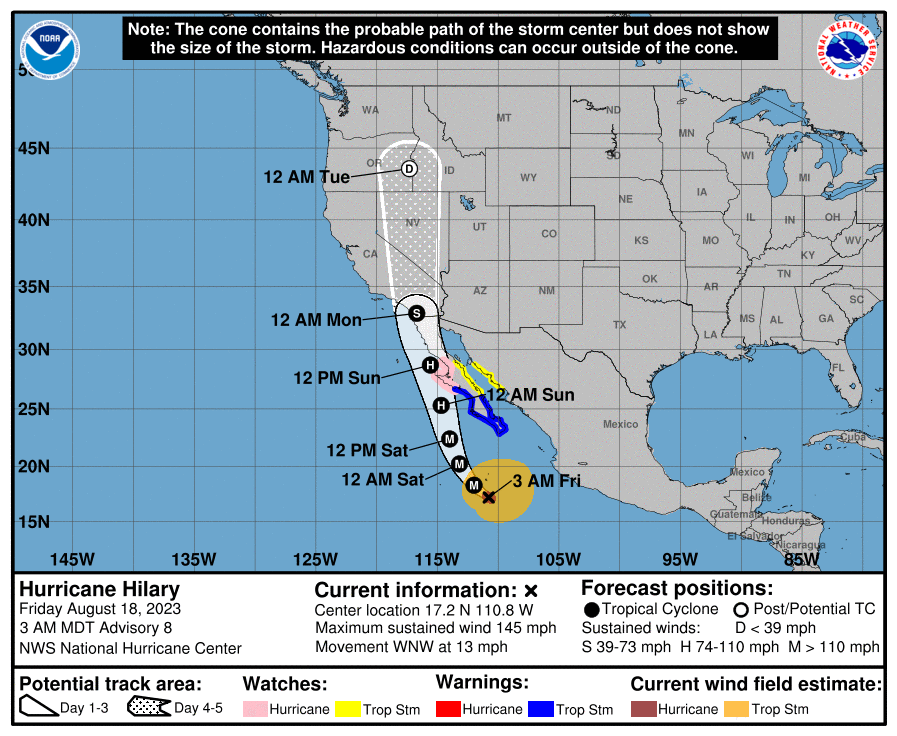 ON THIS DATE IN 1925: During the late morning a severe hailstorm struck southeastern Iowa, destroying crops along a path 6 to 10 miles wide and 75 miles long. The hail also injured and killed poultry and livestock, and caused $2.5 million damage. The hailstorm flattened cornfields to such an extent that many had to leave their farms in search of other work.
ON THIS DATE IN 1931: The Yangtze River in China peaked during a horrible flood that killed 3.7 million people directly and indirectly over the next several months. This flood was perhaps the worst natural disaster of the 20th century.
ON THIS DATE IN 1991: Hurricane Bob brushed the Outer Banks of North Carolina; it would make landfall the following day on Long Island. Bob left extensive damage throughout New England in its wake, and 18 fatalities were reported in association with the system. The loss of life and most of the damage occurred as a result of high winds and rough seas. There were six confirmed tornadoes during its passage. Bob is the most recent hurricane to hit the New England states directly as a hurricane.
For more weather news and information from James Spann and his team, visit AlabamaWx.