James Spann: A few spotty showers for Alabama today and Thursday, with lower heat levels

James Spann forecasts scattered showers in the southern half of Alabama from Alabama News Center on Vimeo.
RADAR CHECK: We have a few isolated showers just before daybreak near a surface front just south of I-20, but most of Alabama is dry with temperatures between 67 and 74 degrees. The front will drift slowly southward this morning before becoming nearly stationary, and we will maintain the chance of widely scattered showers or storms mostly over the southern half of the state. Otherwise, expect a mix of sun and clouds with highs generally in the mid to upper 80s.
The weather won’t change much Thursday. It will be partly sunny with just a few isolated showers or storms. The high will be in the mid 80s, not far from average for mid-September in Alabama.
FRIDAY AND THE WEEKEND: The coverage of showers will likely increase across Alabama Friday and Saturday, but still the rain won’t be especially heavy or widespread. The chance of any one specific spot seeing rain is 30-40% Friday and 50-60% Saturday. The sky will be occasionally cloudy both days with highs in the 80s. Sunday looks mostly dry with only a small risk of a stray shower; the high will be in the mid 80s.
NEXT WEEK: At this point next week looks mostly rain-free for Alabama and the Deep South with highs in the 80s and lows in the 60s.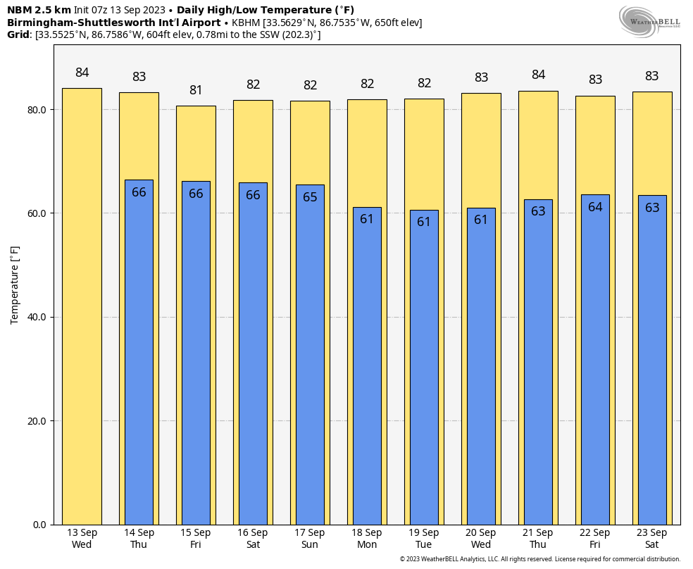 FOOTBALL WEATHER: For the high school games Friday night, a few showers are possible with a mostly cloudy sky; some thunder can’t be ruled out. Temperatures will fall through the 70s.
Saturday, Alabama travels to Tampa to take on South Florida (2:30 p.m. CT kickoff). The day will be hot and humid with a kickoff temperature around 90 degrees. A passing shower or thunderstorm is possible during the game.
Auburn hosts Samford Saturday at Jordan-Hare Stadium (6 p.m. kickoff). The sky will be mostly cloudy with some rain possible at times. Temperatures will be in the mid to upper 70s.
UAB will host Louisiana Saturday in downtown Birmingham at Protective Stadium (6 p.m. kickoff). A few periods of rain are possible during the game. Conditions will be mostly cloudy with temperatures falling from near 80 at kickoff to mid 70s by the fourth quarter.
TROPICS: Hurricane Lee is still packing sustained winds of 115 this morning and is about 475 miles south/southwest of Bermuda. A number of factors — including Lee’s broad structure, increasing shear and potential upwelling of cooler waters — are likely to lead to a very gradual decrease in the hurricane’s maximum winds during the next three days or so. In addition, Lee is likely to begin extratropical transition in two to three days, with that process expected to be complete just before the cyclone’s center reaches the coast of Maine, New Brunswick or Nova Scotia in about four days. That said, Lee’s expected post-tropical transition will not diminish potential wind, rain and coastal flooding impacts in New England and Atlantic Canada due to the system’s broad wind field.

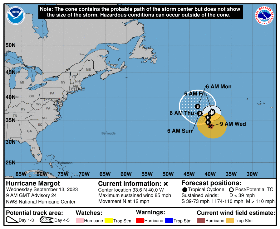
Margot is a hurricane in the central Atlantic with winds of 85 mph. It will slowly weaken over the next five days as it drifts northward far from land.
In the eastern Atlantic, Invest 97L will likely become Tropical Storm Nigel, but global models suggest it will turn north and miss the U.S. No tropical systems will threaten the Gulf of Mexico for at least the next seven days.
ON THIS DATE IN 1978: Little Rock, Arkansas, saw 8.1 inches of rain, which caused major flash flooding. Ten people were killed.
ON THIS DATE IN 1988: Hurricane Gilbert smashed into the Cayman Islands and, as it headed for the Yucatan Peninsula of Mexico, strengthened into a monster hurricane, packing winds of 175 mph. The barometric pressure at the center of Gilbert reached 888 millibars, a record for any hurricane in the Caribbean, Gulf of Mexico or the Atlantic Ocean until Hurricane Wilma in 2005. Gilbert covered much of the Gulf of Mexico, producing rain as far away as the Florida Keys.
ON THIS DATE IN 2008: Hurricane Ike made landfall as a Category 2 storm near Galveston, Texas. Due to its immense size, Ike caused devastation from the Louisiana coastline all the way to the Kenedy County region near Corpus Christi, Texas.
For more weather news and information from James Spann and his team, visit AlabamaWx.


