James Spann: Quiet weather week ahead for Alabama

James Spann forecasts a mostly dry week for Alabama from Alabama News Center on Vimeo.
CLEARING: The sky is still cloudy over much of Alabama this morning, but the clouds will give way to afternoon sunshine as drier air continues to work into the state. Expect a high in the 50s, very close to seasonal averages for late January. Tonight will be clear and cold; a light freeze is likely for the northern half of the state early Tuesday.
REST OF THE WEEK: Tuesday will be another dry day with a mostly sunny sky. A clipper system will bring the chance of a few sprinkles to northeast Alabama Tuesday night, but with limited moisture most places won’t see enough rain to measure.
The weather will be dry Wednesday through Friday with mostly sunny days and fair nights. Highs will be in the 50s Wednesday, between 55 and 65 degrees Thursday and in the 60s statewide Friday.
THE WEEKEND: Saturday will be dry and pleasant with a high in the 60s. Clouds will increase by afternoon, and a weather system will bring rain back into the state Sunday. The most widespread rain will be over the southern two-thirds of the state with highs in the 50s. There will be no risk of severe storms and probably no thunder.
NEXT WEEK: We will maintain the chance of rain statewide Monday; the rest of the week looks dry with highs mostly in the 50s and lows mostly in the 30s. There’s no sign of any bitterly cold arctic air for the Deep South for the next seven to 10 days.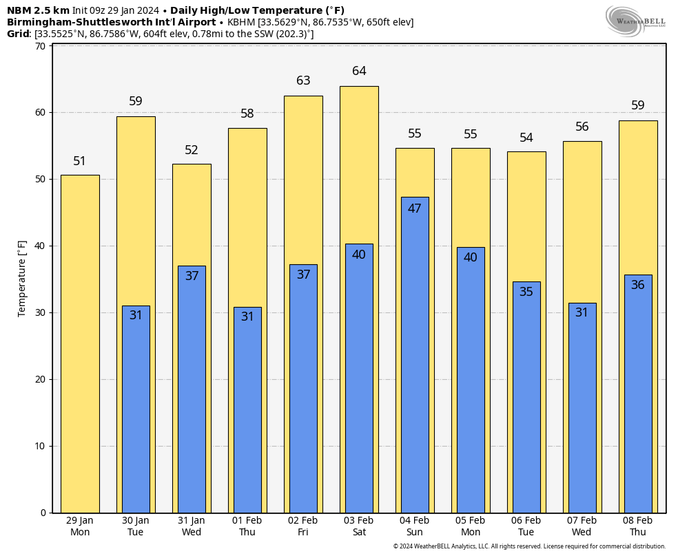
RAIN UPDATE: Here are rain totals for January so far, along with the departure from average:
- Muscle Shoals — 8.73 inches (4.48 inches above average)
- Anniston — 8.32 (4.34 above average)
- Tuscaloosa — 8.03 (3.55 above average)
- Mobile — 8.03 (2.88 above average)
- Huntsville — 6.96 (2.43 above average)
- Birmingham — 6.28 (1.75 above average)
- Dothan — 6 (1.74 above average)
ON THIS DATE IN 2002: A major three-day winter storm blasted parts of Kansas and Missouri. A catastrophic ice storm occurred south of the snow area, with 2 inches of ice and snow accumulating in the Kansas City, Missouri, area. Thousands of trees were felled by the storm, blocking roads, felling utility lines and causing fires. Two “Bicentennial Trees,” estimated at being more than 200 years old, were badly damaged. After Jan. 31, 325,000 people were reported without power in Kansas City alone.
ON THIS DATE IN 2005: Freezing rain produced ice accumulation across parts of east Alabama. Significant icing occurred across Randolph and Chambers counties. One-quarter inch to 1 inch of ice accumulations was reported countywide. Widespread power outages occurred due to icing on power lines and trees that fell onto power lines because of the weight of the ice that accumulated on them. Across Cherokee, Etowah, St. Clair, Calhoun, Cleburne, Talladega, Clay, Coosa, Tallapoosa and Lee counties, widespread icing occurred on elevated and colder surfaces. Reports of ice on trees, bridges and vehicles were common in these areas. Across the higher elevations on Mount Cheaha, one-half to 1 inch of ice accumulated.
For more weather news and information from James Spann and his team, visit AlabamaWx.


