James Spann: Summer-like mix of sun, showers for Alabama Saturday, Sunday
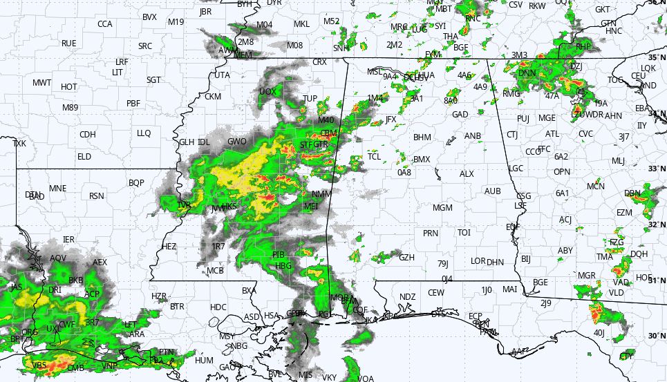
RADAR CHECK: We have a classic case of random, scattered showers across Alabama this afternoon. There are a few thunderstorms as well; otherwise, we have a mix of sun and clouds with temperatures mainly in the 80s. Showers will fade late tonight.
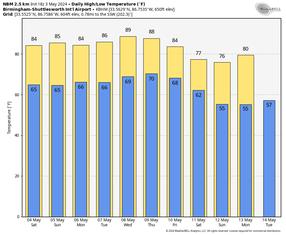
THE ALABAMA WEEKEND: It will be a mixed bag, with periods of sun and random, scattered showers Saturday and Sunday — not a washout at all, but you will see some rain from time to time. Higher rain probabilities will remain over the northern half of the state. Some thunder is possible, but there is no risk of severe storms. Afternoons will stay warm, with highs in the mid 80s.
NEXT WEEK: A few widely scattered showers will remain possible pretty much daily through the week. Otherwise, look for partly sunny days with highs in the mid to upper 80s. A cold front will likely bring a higher coverage of showers and thunderstorms on Friday.
ON THIS DATE IN 1999: There were 63 tornadoes in Oklahoma, making this the worst outbreak ever to strike the state. In central Oklahoma alone, eight individual supercell thunderstorms produced 57 tornadoes. Bridge Creek, Moore and southern parts of the Oklahoma City metro area were hit the hardest. When it was near Moore, Oklahoma, a truck-mounted Doppler radar measured a wind speed of 318 mph, the highest ever observed in a tornado.
Forecasters at the Storm Prediction Center (SPC) in Norman, Oklahoma, were faced with the unprecedented situation of a major tornado on the ground threatening their location. As a major F5 tornado was approaching the Oklahoma City metro area from the southwest, the SPC notified its backup, the Air Force Weather Agency at Offutt Air Force Base in Omaha, Nebraska, that they might have to assume operational responsibility if the tornado approached Norman. The storm remained several miles west of the facility but was visible from the SPC roof. Damage from this single tornado was around $1 billion, making it the costliest tornado in history.
To the north in Kansas, an F4 tornado tracked 24 miles through Sumner and Sedgwick counties, killing six, injuring 154 and causing $146 million in damages.
ON THIS DATE IN 2009: A derecho moved across central Alabama on Sunday afternoon. A derecho is a widespread and long-lived straight-line windstorm associated with a fast-moving squall line. It can produce a long-lived gust front that causes straight-line wind damage with winds over 58 mph. This derecho produced damage in several counties from the Mississippi state line to the Georgia state line. In addition, five tornadoes touched down across the state.
For more weather news and information from James Spann and his team, visit AlabamaWx.


