James Spann: Showers, storms more numerous across Alabama today
James Spann forecasts rain for many in Alabama today from Alabama News Center on Vimeo.
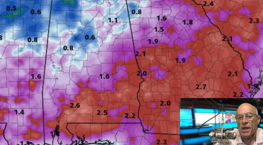
RADAR CHECK: We are watching an organized batch of rain and storms over west Tennessee early this morning; if it holds together, it will enter the northeast corner of Alabama a little later with some heavy rain and gusty winds. Additional showers and storms will form over the rest of the state later in the day ahead of a surface front; odds of any one spot seeing rain today are 60-70%. We still can’t promise rain for everyone, but most places should get a decent downpour at some point. The sky will be cloudy at times, with a high between 90 and 95 degrees.
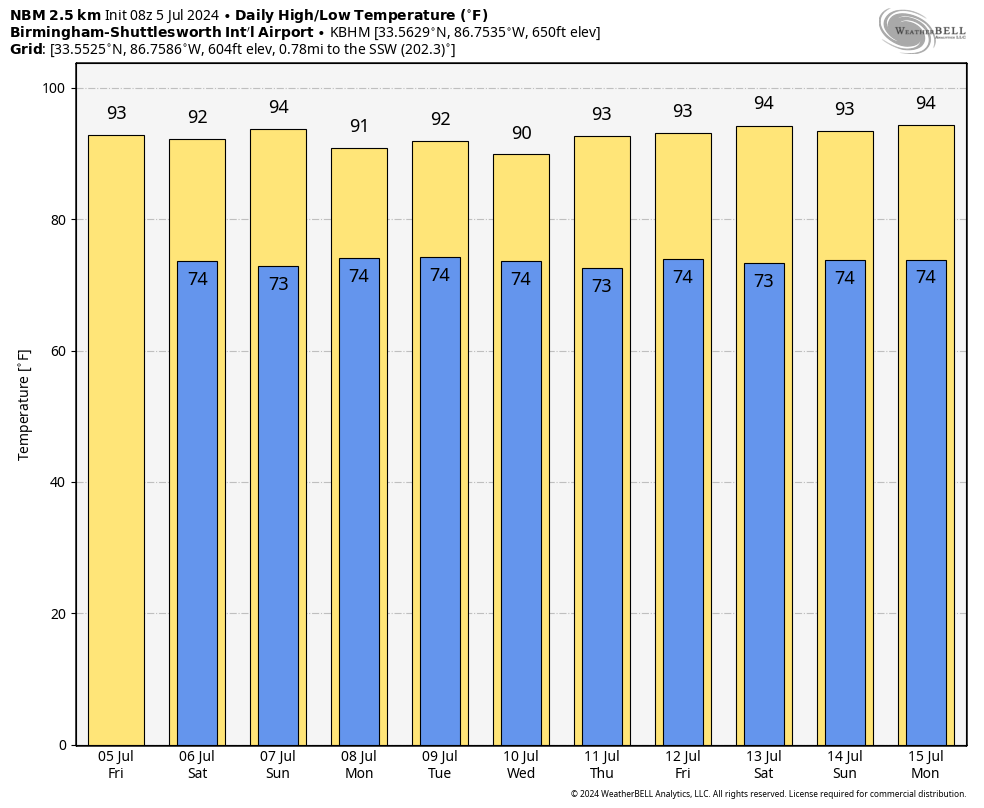
THE ALABAMA WEEKEND: Drier air will temporarily enter the northern counties of the state, meaning the best chance of scattered showers and storms Saturday and Sunday will be across south Alabama. Highs will remain in the low to mid 90s, but lower dew points over north Alabama will make the heat a little more bearable.
NEXT WEEK: Moisture levels rise statewide, and we will mention scattered showers and storms daily through the week with highs between 90 and 94 degrees. We could see an increase in the coverage of showers and storms by midweek as deeper tropical moisture associated with the remnants of Beryl move in.
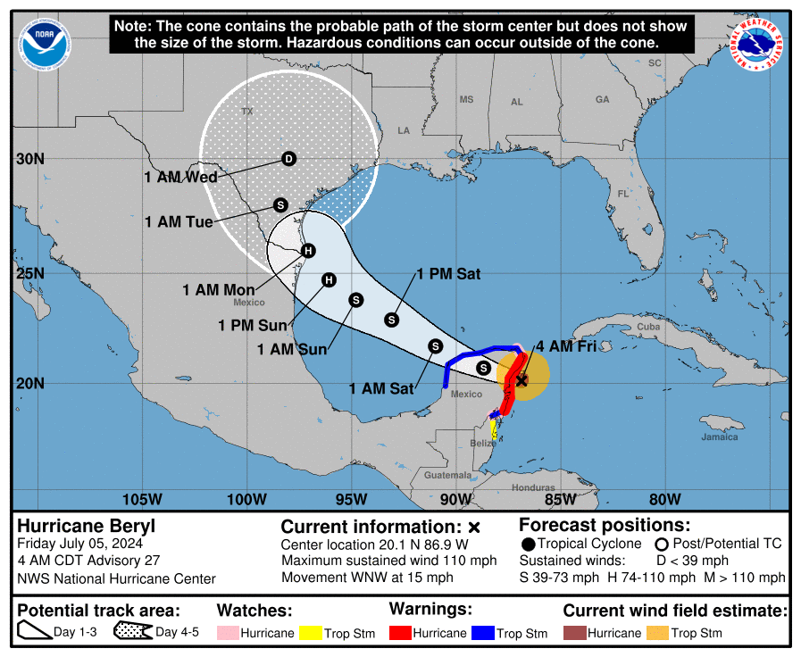
TROPICS: Hurricane Beryl is moving into Mexico’s Yucatan Peninsula early this morning with winds of 110 mph. The system will emerge into the southwest Gulf of Mexico tonight as a tropical storm; the National Hurricane Center (NHC) expects it to become a hurricane again with 85 mph winds before the final landfall near the southern tip of Texas late Sunday or early Monday morning.
The average NHC track error three days out is around 100 miles, and it remains too soon to pinpoint where the largest impacts will be. However, watches for portions of northeastern Mexico and south Texas will likely be required later today.
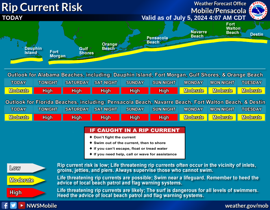
 While there will be no weather impact on the central Gulf Coast (Gulf Shores to Panama City Beach), there will be a high danger of rip currents there Saturday and Sunday.
The rest of the Atlantic basin is quiet, and additional tropical storm formation is not expected through next week.
ON THIS DATE IN 1937: The temperature at Medicine Lake, Montana, soared to 117 degrees to tie the state record. Glendive, Montana, reached 117 degrees on July 20, 1893.
For more weather news and information from James Spann and his team, visit AlabamaWx.


