James Spann: Higher rain chances, lower heat levels ahead for Alabama
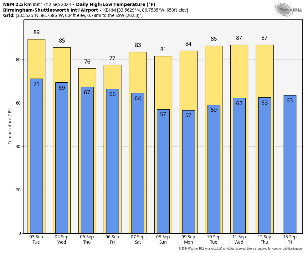
SUNNY LABOR DAY: The sky is mostly sunny across Alabama this afternoon with just a few isolated showers across the southeast counties of the state. Temperatures range from the upper 80s over the northern half of the state to the mid 90s across southeast Alabama. Tonight will be mostly fair with a low between 67 and 74 degrees.
Moisture levels rise Tuesday, and we will bring in the chance of a few widely scattered showers and thunderstorms, mostly during the afternoon and evening. A few showers or storms are possible Wednesday, but rain coverage should be much higher Thursday and Friday. Periods of rain are likely both days with temperatures only in the mid 70s over the northern half of the state; many spots across south Alabama won’t get past the low 80s. Rain amounts Tuesday through Friday will be about 2 inches for much of Alabama, with potential for 2-4 inches closer to the Gulf Coast, where a trough of low pressure will set up.
THE ALABAMA WEEKEND: A cold front will push through the state early in the weekend; we will need to hang on to some risk of showers Saturday, mainly during the morning. The rest of the weekend will be dry and pleasant; temperatures dip into the 50s Sunday morning over the northern two-thirds of the state. Highs will be mostly in the low to mid 80s both days.
Global models suggest the weather will remain generally dry for much of the following week with seasonal temperatures.
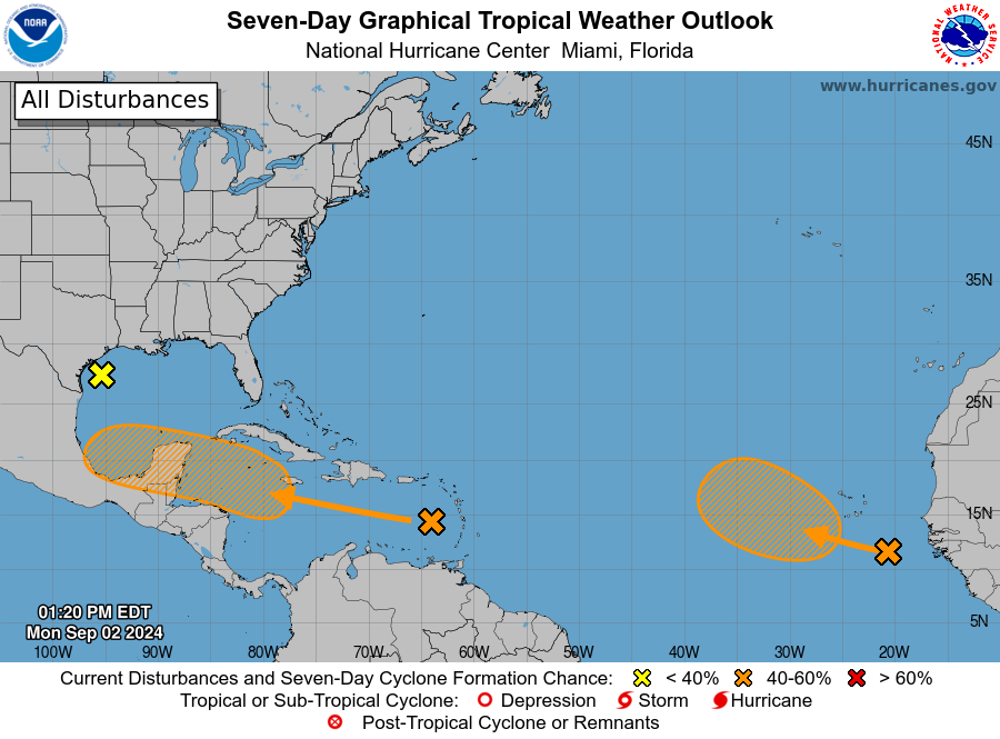
TROPICS: The National Hurricane Center (NHC) is monitoring three areas across the Atlantic basin:
- A broad, weak area of low pressure just offshore of the middle Texas coast continues to produce some disorganized shower activity near the coast and over the adjacent waters of the northwestern Gulf of Mexico. This system is expected to move inland early Tuesday, and development is not expected. Heavy rains could cause some flash flooding across portions of the Texas coast during the next day or two.
- A tropical wave over the far eastern Atlantic is producing disorganized showers and thunderstorms. Environmental conditions are forecast to become a little more conducive for development, and a tropical depression could form in a few days while the disturbance moves slowly west-northwestward or northwestward over the eastern tropical Atlantic Ocean. This system could produce areas of heavy rain and gusty winds across portions of the Cabo Verde Islands in a day or two. The NHC gives it a 40% chance of development over the next seven days; if a depression or storm does form, most global models show a turn to the north over the open Atlantic, far from land.
- A tropical wave is producing disorganized thunderstorms and gusty winds across portions of the Lesser Antilles, Puerto Rico, Hispaniola and adjacent waters. Environmental conditions are forecast to become more conducive for development when the system reaches the western Caribbean Sea and southwestern Gulf of Mexico late this week and over the weekend, and a tropical depression could form during that time. The chance of development is holding at 40%. Most global models move the wave into the Bay of Campeche in a week or so with little development. It remains just something to watch for now.
 ON THIS DATE IN 1935: The 1935 Labor Day Hurricane was an extremely powerful and devastating Atlantic hurricane that struck the southeastern United States. For several decades, it was the most intense Atlantic hurricane on record in terms of barometric pressure until being surpassed by Hurricane Gilbert in 1988. It is one of four Category 5 hurricanes on record to strike the contiguous United States, along with Hurricane Camille (1969), Hurricane Andrew (1992) and Hurricane Michael (2018).
The hurricane passed near Long Key on Labor Day evening. It caused catastrophic damage in the upper Florida Keys as a storm surge of approximately 18 to 20 feet swept over the low-lying islands. The hurricane’s strong winds and the surge destroyed nearly all the structures between Tavernier and Marathon. The town of Islamorada was obliterated. The hurricane claimed at least 485 lives, including about 260 World War I veterans working on a section of the Overseas Highway in a federal relief project. Bodies were recovered as far away as Flamingo and Cape Sable on the southwest tip of the Florida mainland.
ON THIS DATE IN 1985: Elena made landfall near Biloxi, Mississippi, as a Category 3 major hurricane. In Alabama, Dauphin Island suffered the brunt of the storm. Storm surge was measured at 8.4 feet on the Gulf side and 3.5 feet on the bay side of Dauphin Island. The surge cut all the way across low-lying parts of the island with severe beach erosion and damage to roads. In fact, it eroded streets, which exposed and destroyed the water and sewer pipelines underground. Nine deaths were attributed to the hurricane in four states and on the waters of the Gulf of Mexico, and 134 people along Elena’s path were hospitalized.
For more weather news and information from James Spann and his team, visit AlabamaWx.


