James Spann: Alabama gets wet today, colder Wednesday
James Spann has the Alabama forecast for the work week ahead from Alabama NewsCenter on Vimeo.
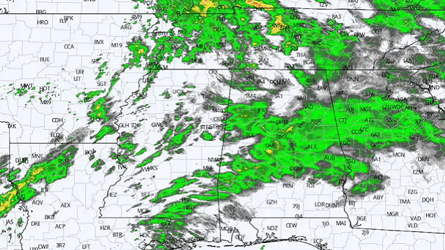
WET MONDAY: An approaching upper trough will bring lots of rain to Alabama today along with some potential for thunder. There is very little surface-based instability and no severe storms are forecast here, although the Storm Prediction Center does have a marginal risk (level 1 of 5) defined for areas just to the northwest, including Memphis. Temperatures will hold in the 50s over the northern half of the state today, and rain amounts should be in the one-half-inch to 1-inch range. No flash flooding problems are anticipated. The rain will end from west to east tonight.
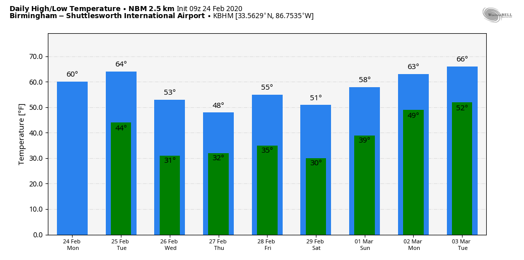
A slot of dry air will cover Alabama Tuesday; we are forecasting a mix of sun and clouds with a high in the mid 60s.
COLDER AIR WEDNESDAY: A cold front will pass through Alabama Wednesday morning; it could squeeze out a few showers over north Alabama, but moisture will be very limited, and most places won’t see any meaningful rain. Otherwise the day will be occasionally cloudy, breezy and colder, with a high between 48 and 52 degrees.
Thursday and Friday will be dry with cold mornings. Morning lows will be in the 25- to 30-degree range. The highs will be close to 50 Thursday, followed by low 50s Friday. These values are about 10 degrees below average for late February in Alabama.
THE ALABAMA WEEKEND: A disturbance passing down the back side of an upper trough over the eastern U.S. might squeeze out a few sprinkles or flurries Saturday morning, but, with very little moisture, for now it doesn’t look like anything significant. Most places will be dry Saturday with a mix of sun and clouds. The high will be in the low 50s. Then, on Sunday, the day will be sunny with a high in the upper 50s after a subfreezing morning.
NEXT WEEK: Temperatures rise into the 60s Monday and Tuesday, and global models suggest the next rain event comes Tuesday night into Wednesday.
RAIN UPDATE: Birmingham’s official rain total for February so far is 12.31 inches. That makes 2020 the third-wettest February on record, behind February 1961 (17.67 inches) and February 1903 (15.86 inches). Current rain projections for the next seven days suggest February 2020 will most likely stay in third place.
ON THIS DATE IN 1969: The famous “100-Hour Storm” began in Boston. Snow fell much of the time between early on the 25th through noon on the 28th. The 26.3 inches at Logan Airport is the second-greatest snowstorm in Boston’s history. Seventy-seven inches fell at Pinkham Notch Base Station in New Hampshire, bringing its February total to 130 inches. Its snow cover on the 27th was 164 inches. Mt. Washington, New Hampshire, received 172.8 inches of snow in the month.
BEACH FORECAST: Click here to see the AlabamaWx Beach Forecast Center page.
WEATHER BRAINS: You can listen to our weekly 90-minute show any time on your favorite podcast app. This is the show all about weather featuring many familiar voices, including the meteorologists at ABC 33/40.
CONNECT: You can find me on the major social networks:
Facebook
Twitter
Instagram
Pinterest
Snapchat: spannwx
For more weather news and information from James Spann and his team, visit AlabamaWx.com.


