James Spann: Sally nearly stationary; heavy rain the main concern for Alabama

James Spann forecasts dangerous flooding for Alabama Gulf Coast on Wednesday from Alabama NewsCenter on Vimeo.
STILL QUIET TODAY: Alabama’s weather will remain quiet for the northern two-thirds of the state today, but the sky will be mostly cloudy as the canopy of high cirrus clouds from Hurricane Sally spreads northward. Any showers this afternoon should be widely scattered; most of the rain today will remain near the Gulf Coast.
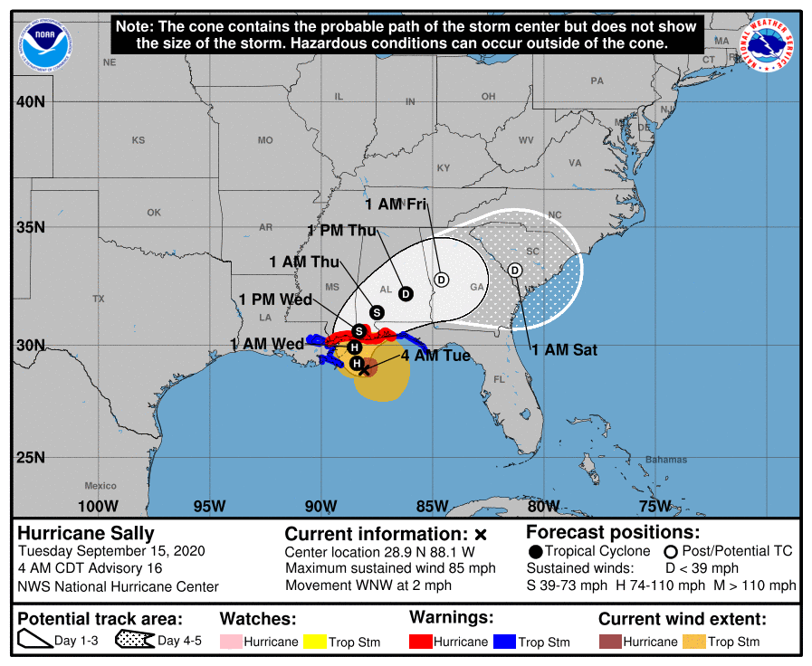
Sally will creep inland early Wednesday, and the system will weaken and turn northeast, moving through central Alabama. This is what we expect, in terms of the inland impact:
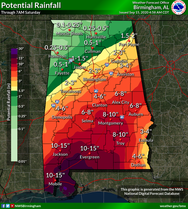
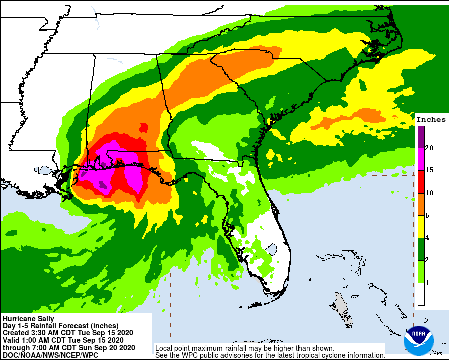
RAIN: A Flash Flood Watch is in effect for areas along and south of I-20 for Wednesday (along and south of a line from Tuscaloosa to Birmingham to Anniston). Rain amounts of 5-10 inches are likely over southeast Alabama (from Montgomery south and east), with totals closer to 2-4 inches up to I-20. There will be a sharp cutoff in terms of rain amounts on the northern fringe of Sally, and exactly where that happens remains somewhat uncertain. Rain amounts will be very light for the northern third of the state.
WIND: Winds on Wednesday will be in the 15-30 mph range. We do not expect any major tree or power line damage and no widespread power outages for most of the state. (It’s a different story along the Gulf Coast, where winds will be much higher.)
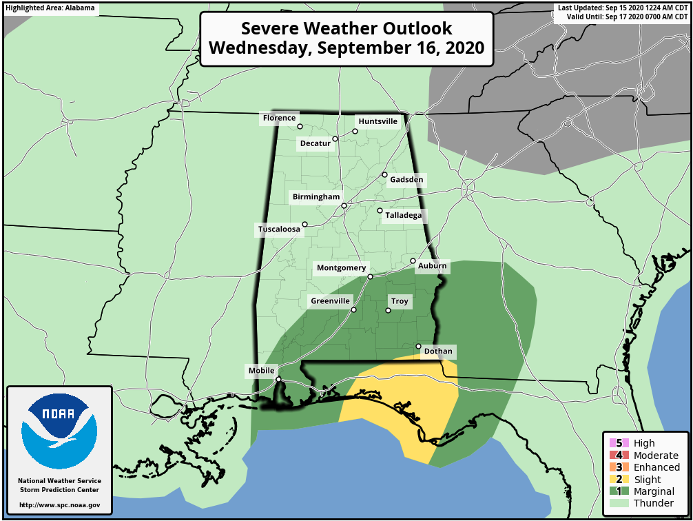
TORNADOES: A few brief, isolated tornadoes are possible over the southern half of the state Wednesday, generally south of a line from Mobile to Montgomery to Opelika. The higher probability is over the southeast part of the state.
The rain will end from west to east during the day Thursday as Sally moves out of the state.
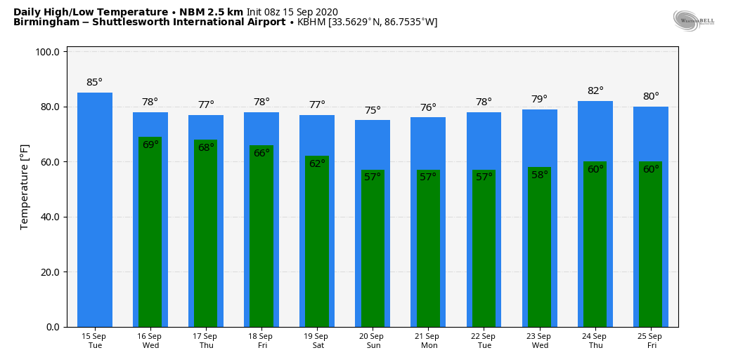
FRIDAY AND THE WEEKEND: The weather will be delightful, with sunny, pleasant days and fair, cool nights. Highs will be between 76 and 80, lows between 57 and 62. It will feel like fall.
NEXT WEEK: The weather will stay mostly dry next week with very comfortable temperatures.
SALLY’S COASTAL IMPACT: Hurricane Sally now has sustained winds of 85 mph and is about 115 miles south of Biloxi. It is practically stationary, drifting to the west/northwest at only 2 mph.
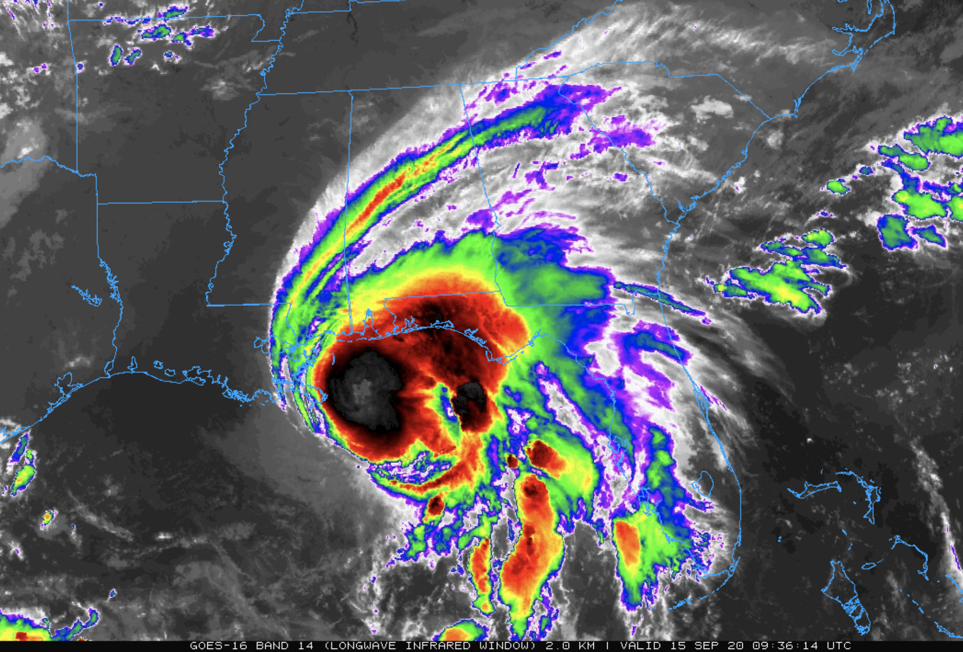
The hurricane is now expected to remain in a moderate to high mid-to-upper-level wind shear environment. In addition, some modest upwelling is likely occurring in the inner-core region based on a sea-surface temperature decrease of nearly 2 degrees during the past 24 hours, according to data from buoys. This caused the weakening trend overnight. Accordingly, Sally is expected to make landfall as a Category 1 hurricane early Wednesday near the Alabama/Mississippi border.
Historic flooding is possible, with extreme life-threatening flash flooding likely through Wednesday along and just inland of the central Gulf Coast from the western Florida Panhandle to far southeastern Mississippi. Widespread moderate to major flooding on area rivers is forecast along and just inland of the central Gulf Coast. Some spots could see 20 inches of rain over southern Mobile and Baldwin counties, and the western part of the Florida Panhandle.
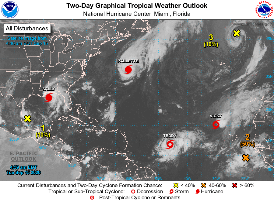
REST OF THE TROPICS: Hurricane Paulette is headed into the North Atlantic and is no threat to land. Teddy is expected to become a major hurricane in coming days; our friends in Bermuda will need to watch this one, but it will recurve into the Atlantic well east of the U.S. And Tropical Storm Vicky in the eastern Atlantic is expected to be short-lived.
A new tropical wave has emerged off the coast of Africa with a medium chance of becoming a depression or storm within the next five days.
ON THIS DATE IN 1945: A hurricane entered the south Florida coast at Homestead, curving northward right up through the center of Florida, remaining over land, and exiting near Jacksonville Beach with winds gusting to 170 mph. The following is from the Homestead Air Reserve Base: “On Sept. 15, 1945, three years to the day after the founding of the Homestead Army Air Field, a massive hurricane roared ashore, sending winds of up to 145 miles per hour tearing through the Air Field’s buildings. Enlisted housing facilities, the nurses’ dormitory and the Base Exchange were all destroyed. The roof was ripped from what would later become building 741, the Big Hangar. The base laundry and fire station were both declared total losses. The few remaining aircraft were tossed about like leaves.”
BEACH FORECAST: Click here to see the AlabamaWx Beach Forecast Center page.
WEATHER BRAINS: You can listen to our weekly 90-minute show anytime on your favorite podcast app. This is the show all about weather featuring many familiar voices, including the meteorologists at ABC 33/40.
CONNECT: You can find me on the major social networks:
Facebook
Twitter
Instagram
Pinterest
Snapchat: spannwx
For more weather news and information from James Spann and his team, visit AlabamaWx.


