Scott Martin: A few strong storms possible in Alabama this morning; bright, sunny Sunday ahead
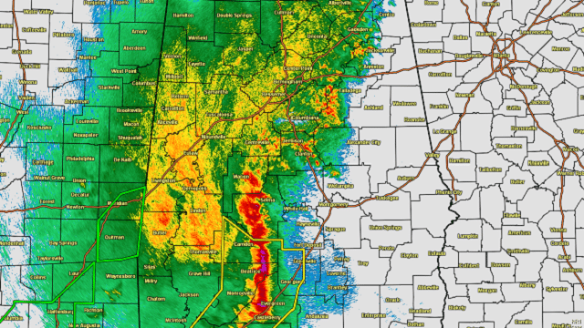
CLEARING SKIES BY AFTERNOON: A line of thunderstorms is pushing across Alabama this morning. While there remains an isolated severe thunderstorm threat for locations east of I-65 along and south of the I-85 corridor, the Storm Prediction Center has determined that instability is too weak over those locations for a new watch to be issued.
A few embedded thunderstorms will continue across the eastern half of central Alabama until 1-3 p.m. Rain for the western half will taper off starting around 8-10 a.m. in the extreme west to around 10 a.m.-noon for the I-65 corridor. Skies will begin to slowly clear out behind the line, with afternoon highs reaching the upper 60s to the lower 70s.
REST OF THE WEEKEND: Sunday will be bright and sunny as troughing will start to work its way out of Alabama. It will be a nice, mild day with highs ranging from the lower 70s in the northwest to the upper 70s in the southeast.
NEXT WEEK: Monday will be much warmer as a flat linear flow sets up. We’ll have plenty of sunshine with highs reaching the upper 70s to the lower 80s.
Tuesday will be a little cooler in parts of the state. A weak impulse may bring a very slight chance of a few isolated to scattered showers and thunderstorms. Afternoon highs will be in the lower 70s to the lower 80s.
Wednesday will feature a little better chance of showers and thunderstorms mainly during the afternoon, but a good many of us will stay dry. Skies will be mostly cloudy with highs in the upper 60s to the upper 70s.
Thursday looks to be dry, but skies will be partly cloudy. Highs will be in the upper 60s to the mid-70s.
Friday looks to be an almost exact copy of Thursday’s weather, a mix of sun and clouds with highs in the upper 60s to the mid-70s.
ON THIS DATE IN 1979: An outbreak of 23 tornadoes ravaged the Red River area of Texas and Oklahoma. This day was known as “Terrible Tuesday” to the residents of Wichita Falls, Texas, as a tornado rated F4 on the Fujita scale ripped through the city. In all, 3,095 homes were destroyed in Wichita Falls, 42 people were killed and damage was set at $400 million, making it the most costly tornado in history up to this time. The tornado width reached 1.5 miles as it passed through the residential section of the city.
For more weather news and information from James Spann, Scott Martin and other members of the James Spann team, visit AlabamaWx.


