James Spann: Wet start to the day for some in Alabama
James Spann forecasts more rain for Alabama this week from Alabama NewsCenter on Vimeo.
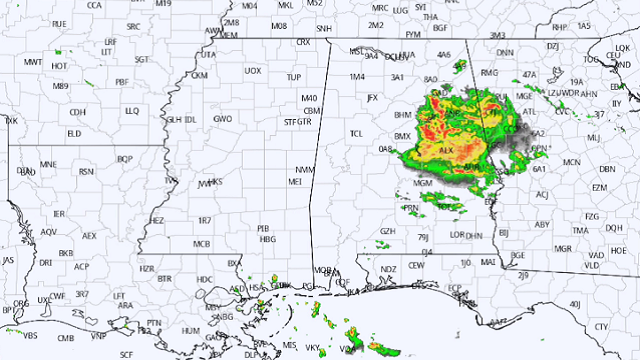
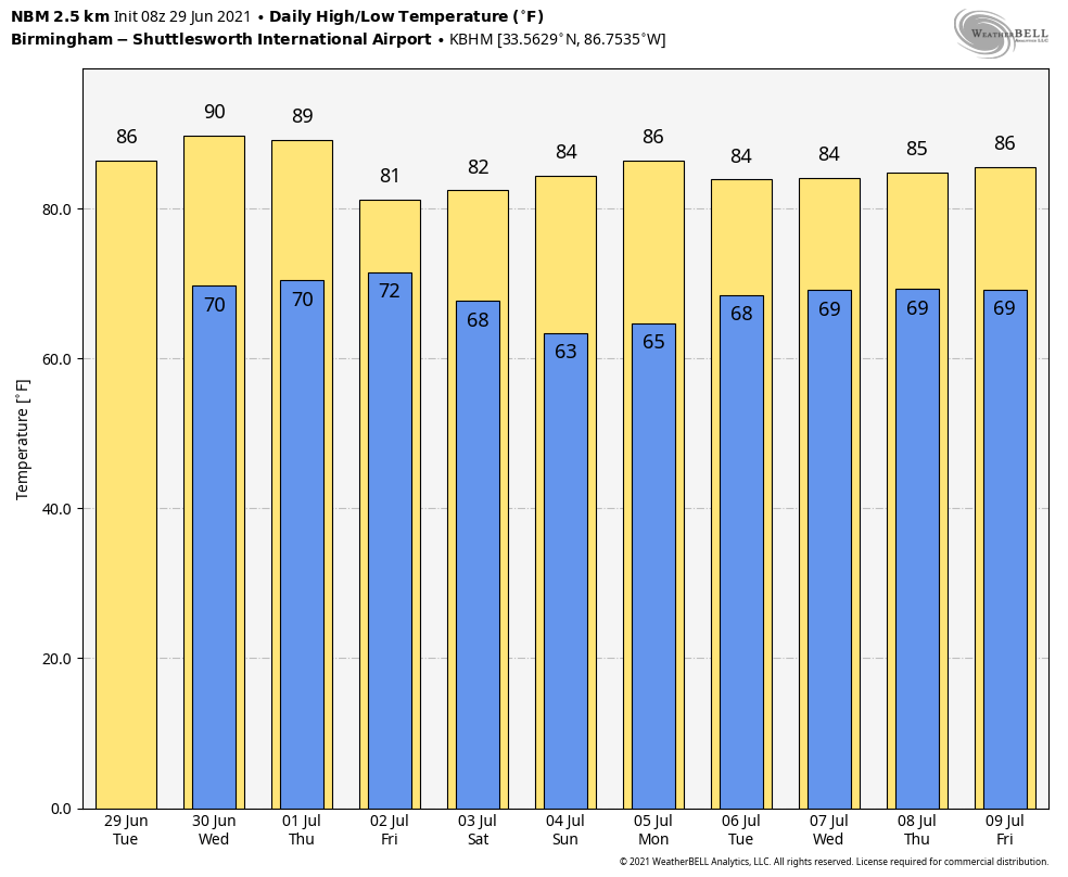
RADAR CHECK: A large mass of rain and thunderstorms is moving westward through central Alabama early this morning; this rain is associated with the remnants of former Tropical Storm Danny that moved into the South Carolina coast Monday from the Atlantic. This organized rain area should move out of the state by mid-morning, and for the rest of the day we expect a mix of sun and clouds with just a few scattered showers or storms redeveloping during the afternoon and evening. Today’s high will be in the mid 80s for most places; the average high for June 29 at Birmingham is 90.
WEDNESDAY/THURSDAY: These two days will feature some pretty routine summer weather — partly sunny days with a few scattered, random, pop-up afternoon and evening showers and thunderstorms. The chance of any one spot getting wet both days is 25-35%, and highs will be mostly in the mid to upper 80s.
FRIDAY AND THE WEEKEND: Coverage of rain and thunderstorms across Alabama will increase Friday as a surface front approaches from the north and becomes almost stationary around the Tennessee state line. The sky will be mostly cloudy, and while it won’t be a total washout, be ready for occasional showers and a few storms.
There is a good bit of uncertainty in the forecast for the holiday weekend. Global models are now trying to push the front southward, suggesting drier air will enter north and central Alabama, possibly as early as Saturday. We will begin to trend the forecast drier for the northern half of the state Saturday and Sunday, with a chance of showers and storms lingering over the southern counties. Highs over the weekend will be in the 80s.
NEXT WEEK: For now it looks like much of the week will feature some pretty typical early July weather, but with temperatures below average. Look for partly sunny days, fair nights and a few scattered showers or storms during the afternoon and evening hours. Highs will be mostly in the 80s, with lows in the 60s.
TROPICS: Danny is dissipating over Alabama and Georgia this morning. Out in the Central Atlantic, disorganized showers and thunderstorms continue in association with a tropical wave about 900 miles east of the Lesser Antilles. Some slow development of this disturbance is possible later this week and this weekend while the system moves westward to west-northwestward at 15 to 20 mph, likely reaching the Lesser Antilles by Wednesday night. It’s way too early to know whether this will be an issue for the U.S.
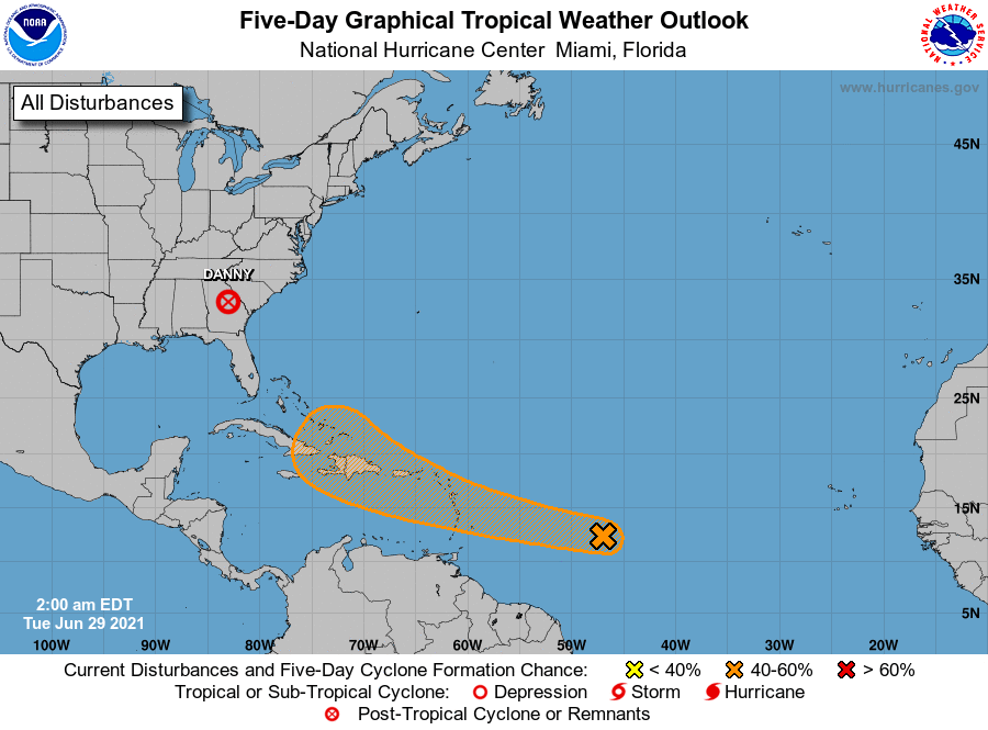
There will be no tropical issues for the Gulf of Mexico through the holiday weekend.
ON THIS DATE IN 1998: The Corn Belt Derecho of 1998 moved through Nebraska, Iowa, Illinois, Indiana and Kentucky. The derecho, which originated in far southeast South Dakota, moved across Illinois during the afternoon and evening and continued as far east as Ohio the next morning. Every county in central Illinois sustained some damage as these severe thunderstorms passed. Winds gusted in the 60 to 80 mph range, with some localized microbursts producing winds of more than 100 mph.
BEACH FORECAST: Click here to see the AlabamaWx Beach Forecast Center page.
WEATHER BRAINS: You can listen to our weekly 90-minute show any time on your favorite podcast app. This is the show all about weather featuring many familiar voices, including the meteorologists at ABC 33/40.
CONNECT: You can find me on the major social networks:
For more weather news and information from James Spann and his team, visit AlabamaWx.


