James Spann: Dangerous Hurricane Ida headed for Gulf Coast, with threats for Alabama
RADAR CHECK: We have scattered showers and thunderstorms in progress across Alabama this afternoon; they are moving northwest and producing heavy rain and a good bit of lightning. But for a decent part of the state, the sky is partly to mostly sunny with temperatures mostly between 87 and 90 degrees. The weather won’t change much over the weekend; look for partly sunny days with scattered, mostly afternoon and evening showers and thunderstorms. The chance of any one spot getting wet Saturday and Sunday is 25-35%, and highs will remain between 87 and 90 degrees for most communities.
Beyond the weekend, we will be greatly affected by Hurricane Ida. Here is a detailed look at the tropical system, and the expected impact for the coast and inland parts of Alabama.
Ida was upgraded to a hurricane around midday today; winds are 75 mph and the system is crossing the western tip of Cuba this evening. The National Hurricane Center forecast track has changed little; landfall is forecast Sunday evening on the Louisiana coast southwest of New Orleans as a major hurricane, at least Category 3 and possibly Category 4.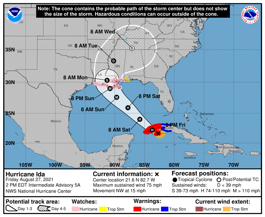
COASTAL IMPACT:
- Ida is expected to be a dangerous major hurricane when it reaches the northern Gulf Coast on Sunday, and the risk of hurricane-force winds continues to increase, especially along portions of the Louisiana coast, including metropolitan New Orleans. Potentially devastating wind damage could occur where the core of Ida moves onshore. A Hurricane Watch remains in effect from Cameron, Louisiana, to the Alabama-Mississippi border. A Tropical Storm Watch is in effect for the Alabama Gulf Coast and Mobile Bay.
- Tropical-storm-force winds (39-73 mph) are likely across Mobile and Baldwin counties Sunday and Sunday night, including Dauphin Island, Gulf Shores, Orange Beach, Mobile and Fairhope. This could bring power outages.
- The risk of life-threatening storm surge inundation is increasing along the coasts of Louisiana, Mississippi and Alabama. Inundation of 7 to 11 feet above ground level is possible within the area from Morgan City, Louisiana, to Ocean Springs, Mississippi, including Lake Borgne.
The combination of a dangerous storm surge and the tide will cause normally dry areas near the coast to be flooded by rising waters moving inland from the shoreline. The water could reach the following heights above ground somewhere in the indicated areas if the peak surge occurs at the time of high tide:
- Morgan City, Louisiana, to Ocean Springs, Mississippi, including Lake Borgne, 7-11 feet
- Rockefeller Wildlife Refuge, Louisiana, to Morgan City, including Vermilion Bay, 4-7 feet
- Ocean Springs to the Mississippi-Alabama border, 4-7 feet
- Mississippi-Alabama border to Alabama-Florida border, including Mobile Bay, 3-5 feet
- Lake Pontchartrain, 4-6 feet
- Lake Maurepas, 3-5 feet
- Sabine Pass to Rockefeller Wildlife Refuge, Louisiana, 2-4 feet
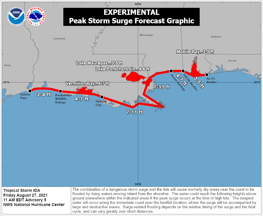
Overtopping of local levees outside of the Hurricane and Storm Damage Risk Reduction System is possible where local inundation values may be higher than those shown above. The deepest water will occur along the immediate coast near and east of the landfall location, where the surge will be accompanied by large and dangerous waves:
- The mayor of New Orleans has called for everyone outside the levee system to evacuate.
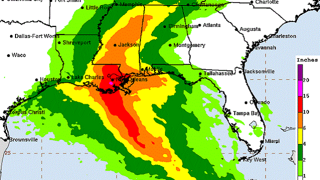
- Ida is likely to produce heavy rainfall later Sunday into Monday across the central Gulf Coast from southeast Louisiana to coastal Mississippi and Alabama, as well as the Lower Mississippi Valley, resulting in considerable flash, urban, small stream and river flooding. Rain amounts across southeast Louisiana, including New Orleans, could exceed 1 foot. Amounts of 4-8 inches are likely along the Alabama Gulf Coast, with 2-4 inches across the Florida Panhandle, including Destin and Panama City Beach.
- A few isolated waterspouts and tornadoes are possible across the Gulf Coast Sunday and Sunday night from the landfall point on the Louisiana coast eastward to the western part of the Florida Panhandle.
- Dangerous rip currents are likely along the entire central Gulf Coast through Monday. Expect double red flags; a number of water rescues were carried out this morning.
- The weather will improve on the coast beginning Tuesday, and routine summer weather is likely Wednesday through Friday with a mix of sun and scattered thunderstorms.
INLAND IMPACT: The NHC is forecasting the circulation of Ida to move through Mississippi Monday and Tuesday, winding up near Muscle Shoals Tuesday night. This puts Alabama on the wet, unsettled east side of the system. Rain over west and southwest Alabama Monday will spread northward, and much of the state will have widespread rain Monday night and Tuesday. The rain could be heavy at times, and flooding is possible. Amounts will be 4-6 inches over the western half of the state, with amounts of 2-4 inches possible for the eastern counties.
In addition to the flooding risk, a few isolated tornadoes will be possible, initially over west and southwest Alabama Monday, and statewide Monday night and Tuesday. But uncertainty remains high regarding the overall evolution of Ida as it moves inland and how buoyant the environment over Alabama will be, so it is a little too early to know the magnitude of the tornado threat. Typically tornadoes associated with tropical systems tend to be short-lived and can touch down with little warning.
Rain will taper off by Wednesday, and drier air arrives Thursday and Friday with lots of sunshine and lower humidity levels.
REMEMBER: This forecast can change. Keep up with the latest updates on Hurricane Ida over the weekend. When it comes to tropical systems, if you are working with old information, you are working with bad information.
ELSEWHERE IN THE TROPICS: Two systems in the Atlantic have some potential to become a tropical depression or storm over the next five days, but both will be moving away from the U.S. and basically are no threat to land.
ON THIS DATE IN 2005: Hurricane Katrina reached Category 3 intensity in the Gulf of Mexico about 335 miles south-southeast of the mouth of the Mississippi River with maximum sustained winds of 115 mph.
BEACH FORECAST: Click here to see the AlabamaWx Beach Forecast Center page.
WEATHER BRAINS: You can listen to our weekly 90-minute show any time on your favorite podcast app. This is the show all about weather featuring many familiar voices, including the meteorologists at ABC 33/40.
CONNECT: You can find me on the major social networks:
For more weather news and information from James Spann and his team, visit AlabamaWx.


