James Spann: Cold front arrives in Alabama very early Wednesday morning
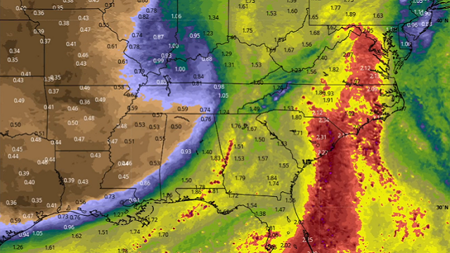
RADAR CHECK: We have scattered showers and thunderstorms in progress across Alabama this afternoon; a few of the stronger storms are producing heavy rain as they move east. Otherwise, there is a mix of sun and clouds with temperatures mostly between 78 and 83 degrees. The average high for Birmingham on Sept. 21 is 85.
Showers and a few storms will remain possible tonight ahead of a strong cold front, but no severe storms are expected.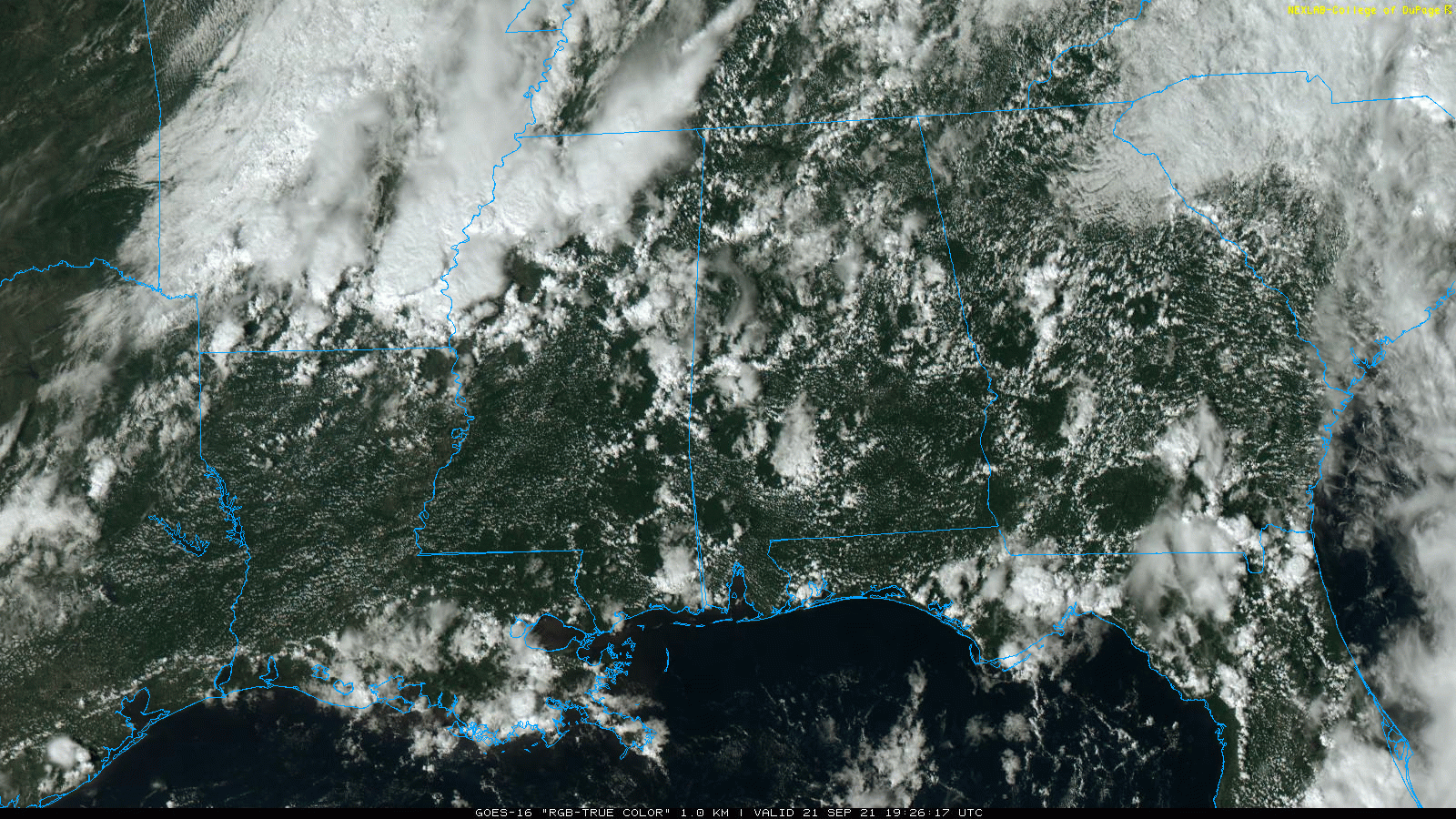
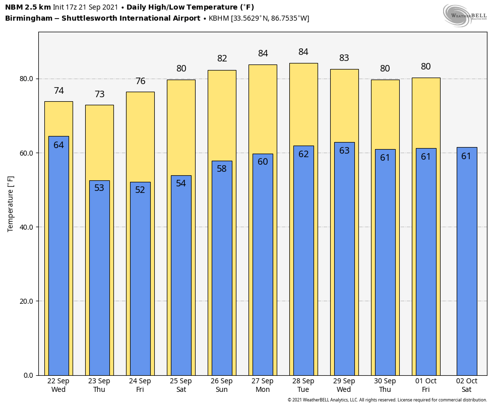
FALL ARRIVES: Wednesday is the first official day of autumn; the equinox comes at 2:20 p.m. We will have approximately 12 hours of daylight and 12 hours of darkness. And, right on time, the first good cold front of the season arrives early Wednesday morning. Showers will end for most areas before 7 a.m.; the sky becomes mostly sunny with a stiff north breeze of 10-20 mph, gusting to 25-30 mph at times during the afternoon. Humidity will drop steadily during the day, and the high will be in the mid 70s.
We are looking at perfect fall weather Thursday through the weekend with sunny, pleasant days and clear, cool nights. Lows early Thursday and Friday mornings will drop into the 45- to 55-degree range, easily the coolest air so far this season. The highs will be in the mid to upper 70s Thursday and Friday, followed by low 80s over the weekend.
NEXT WEEK: Dry weather continues Monday and Tuesday with highs between 81 and 85 degrees; moisture levels rise over the latter half of the week with some risk of showers returning to the state, but at the moment it looks like rain amounts will be fairly light.
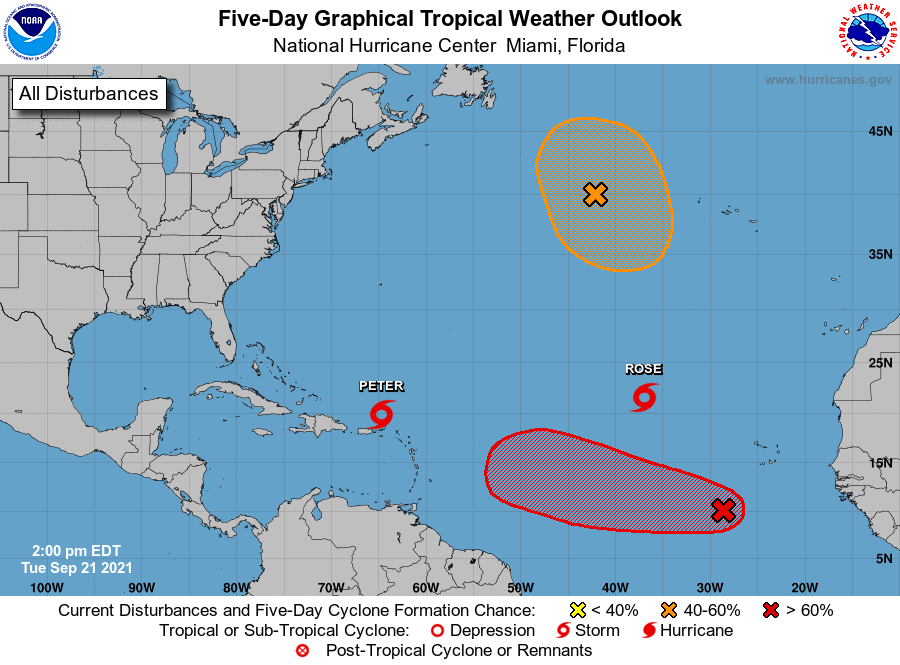
TROPICS: Tropical Storms Peter and Rose in the Atlantic are weak and disorganized, and won’t affect any land area. The remnants of Odette in the North Atlantic are being monitored for possible redevelopment, but if that happens it will remain far from land. Invest 98L in the eastern Atlantic has a high chance of becoming a tropical depression or storm over the next two days as it moves west/northwest, but it will turn north well before reaching the U.S.
The Gulf of Mexico remains very quiet and tropical storm formation is not expected there for the next seven days.
ON THIS DATE IN 1938: A powerful hurricane struck Long Island and southern New England. The Category 3 hurricane was traveling at 47 mph when it made landfall near Bellport, New York. This storm caused at least 600 deaths and left approximately 63,000 homeless.
ON THIS DATE IN 1989: Hurricane Hugo made landfall on Isle of Palms, South Carolina, as a Category 4 hurricane. This storm brought strong winds to many areas of South Carolina. In downtown Charleston, sustained winds of 87 mph were reported, along with gusts of 108 mph. At the time, Hurricane Hugo was the strongest storm to strike the United States in the previous 20-year period. The hurricane was also the nation’s costliest in terms of monetary losses, with approximately $7 billion in damage. An estimated 49 deaths were directly related to the storm, including 26 in the U.S., Puerto Rico and the U.S. Virgin Islands.
BEACH FORECAST: Click here to see the AlabamaWx Beach Forecast Center page.
WEATHER BRAINS: You can listen to our weekly 90-minute show any time on your favorite podcast app. This is the show all about weather featuring many familiar voices, including the meteorologists at ABC 33/40.
CONNECT: You can find me on the major social networks:
For more weather news and information from James Spann and his team, visit AlabamaWx.


