James Spann: Cold, dry weather for Alabama today; warm Christmas weekend ahead
James Spann forecasts one more cold day, night for Alabama from Alabama NewsCenter on Vimeo.
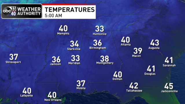
SUNNY AND SEASONAL: Dry air has returned to Alabama; we started the day with a clear sky and temperatures between 28 and 35 degrees for most places. The sky will be sunny today with a high in the mid 50s; the average high for Birmingham on Dec. 22 is 56. Tonight will be clear and cold; most places will go below freezing early Thursday, in the 24- to 32-degree range. It will most likely be our last subfreezing morning of 2021.
THURSDAY THROUGH THE CHRISTMAS WEEKEND: Look for a big warm-up Thursday. With sunshine in full supply, expect a high in the low 60s. Then we rise into the upper 60s Friday with a good supply of sunshine.
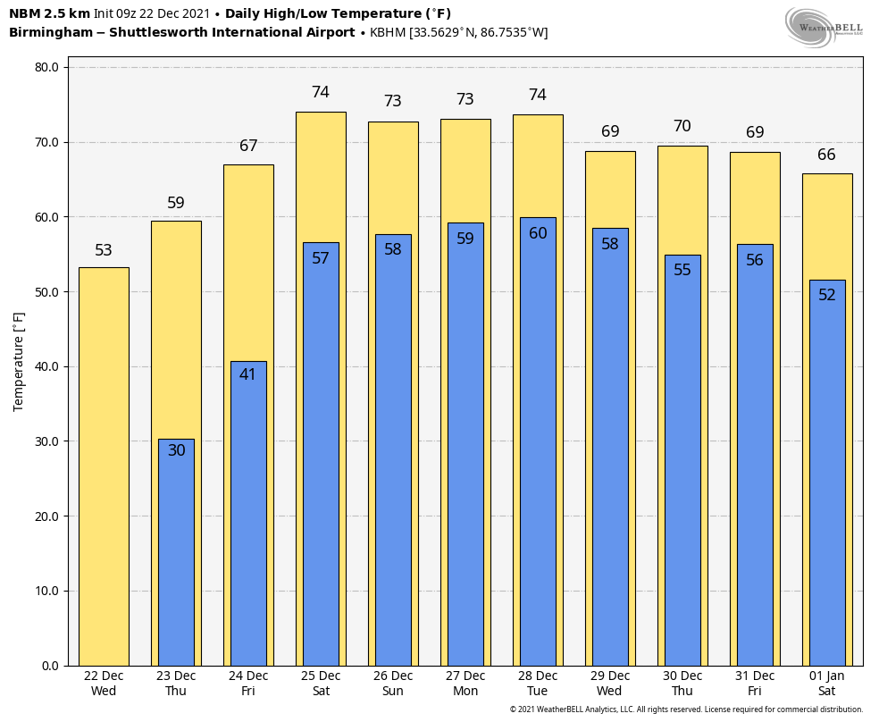
Christmas Day will be dry and warm, with a high in the low to mid 70s. The latest National Blend of Models is printing a high of 74 degrees for Birmingham Saturday. If we reach that, it will be a tie with 1987 for the third-warmest Christmas Day on record. Temperatures have reached or exceeded 70 degrees in Birmingham on Christmas 10 times since 1900:
- 2016 — 78
- 2015 — 77
- 1987 — 74
- 1982 — 73
- 1972 — 73
- 1964 — 72
- 1926 — 71
- 1922 — 71
- 1919 — 70
- 1901 — 70
Sunday will be dry as well; we are forecasting a partly to mostly sunny sky with a high between 70 and 75 degrees.
NEXT WEEK: Mild weather will continue across the Deep South thanks to an upper ridge over the northern Gulf of Mexico. New global model data suggests some rain is likely over the northern two-thirds of the state by Wednesday.
 While we will see temperatures above average next week, brutally cold air will cover parts of the northern U.S. and the western half of Canada. Many places there stay below zero all week. We will keep an eye on that air mass, since at some point it will have to move.
ON THIS DATE IN 1929: Weather records show that 5.5 inches of snow fell at the Birmingham Weather Bureau office. On Dec. 24, there was still 2.5 inches of snow on the ground at 7 p.m. However, most of the snow melted Christmas Day when the temperature climbed to 51 degrees.
ON THIS DATE IN 1989: Extremely cold air rolled into the Deep South. A dusting of snow fell across most of north Alabama, but parts of Sand Mountain had 1 inch of accumulation, with 2 inches in Crossville. Even more amazing was the snowfall that was occurring along the Gulf Coast, the Florida Peninsula and up the Georgia Coast. Snow and ice covered the ground in New Orleans. It snowed in places like Dauphin Island, Gulf Shores, Panama City Beach, Tampa and Daytona Beach. It was the most widespread snowstorm in the history of Florida. Two inches fell at Savannah and 3.9 inches in Charleston, South Carolina. As the low moved up the coast it intensified, dumping an astonishing 15 inches of snow at Wilmington, North Carolina, and 13.3 inches at Cape Hatteras.
BEACH FORECAST: Click here to see the AlabamaWx Beach Forecast Center page.
WEATHER BRAINS: You can listen to our weekly 90-minute show any time on your favorite podcast app. This is the show all about weather featuring many familiar voices, including the meteorologists at ABC 33/40.
CONNECT: You can find me on the major social networks:
For more weather news and information from James Spann and his team, visit AlabamaWx.


