James Spann: Very humid day for Alabama with occasional summer soakers
James Spann forecasts more storms for Alabama from Alabama NewsCenter on Vimeo.
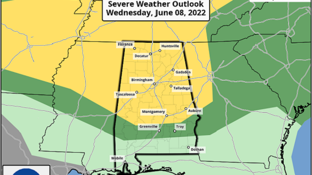
RADAR CHECK: A large batch of rain and storms has been moving through Alabama early this morning with gusty winds, heavy rain and lots of lightning. Flash flood warnings are in effect at sunrise for parts of Jefferson, Shelby, Cullman, Winston and Walker counties. Some communities have picked up more than 3 inches of rain over the past six hours with this batch of storms. The rain tapers off and ends by midmorning, but another batch of storms is likely late this afternoon and tonight. The Storm Prediction Center has defined a slight risk (level 2 out of 5) of severe thunderstorms for the northern two-thirds of the state; these storms will have the potential to bring strong straight-line winds and hail as they pass through.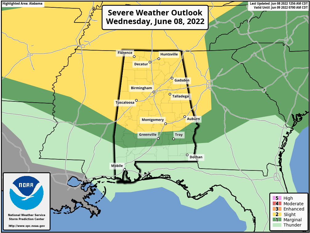 We will also have to watch for more flooding with the afternoon and evening storms since the ground is now totally saturated in many places. Otherwise, the sky will feature more clouds than sun today with a high in the mid 80s.
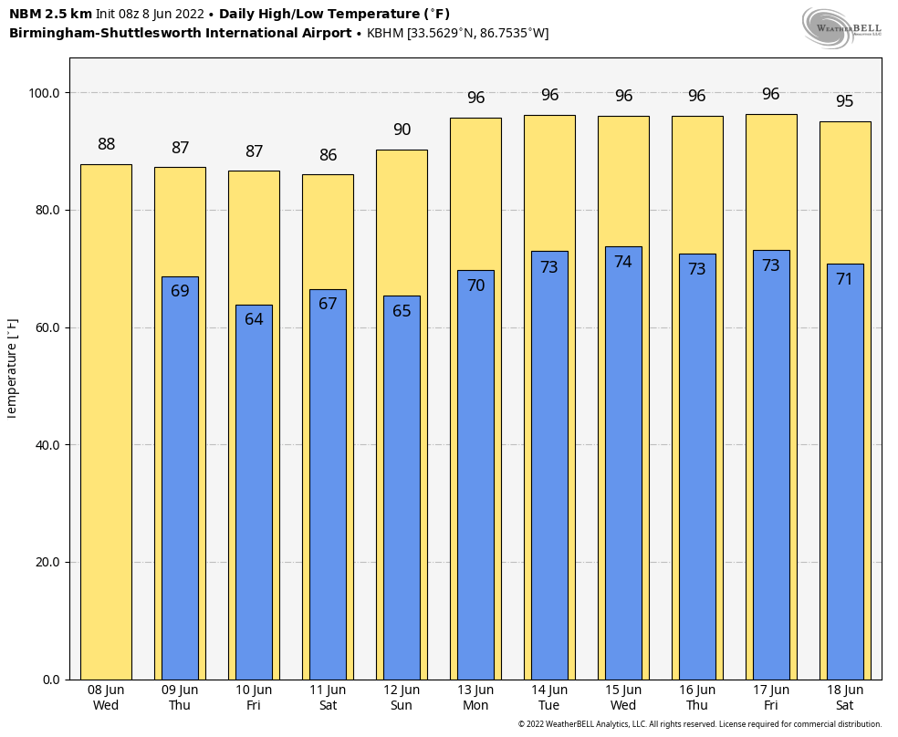
REST OF THE WEEK: Thursday should be drier, but a few scattered storms could still form during the afternoon and evening. Same thing Friday — we’ll have some sun during the day with scattered showers and storms possible. Highs will be in the mid to upper 80s.
THE ALABAMA WEEKEND: We will keep the classic summer forecast going for Saturday and Sunday — partly sunny days with pop-up showers and storms, mostly from about 2 until 10 p.m. The chance of any one spot getting rain both days is 40-50%, and highs will be between 86 and 90 degrees.
NEXT WEEK: An upper high will build over the Deep South, meaning rising heat levels and fewer showers and thunderstorms. Temperatures will reach the low to mid 90s most days.
 TROPICS: All remains very quiet across the Atlantic basin, and tropical storm formation is not expected through the weekend.
RAIN TOTALS: Radar estimates suggest 5-7 inches of rain came down Tuesday around Hokes Bluff and Glencoe in Etowah County, with very significant flooding across much of the county. Some observations early this morning include 4.8 inches in the Oxmoor Valley section of Birmingham, 3.37 inches at Hueytown, 3.11 inches at Morris (northern Jefferson County) and 2.66 inches at Bessemer.
ON THIS DATE IN 2001: Tropical Storm Allison hit Houston, Texas, for the second time in three days. Louisiana and southern Texas were inundated with rain. Baton Rouge received 18 inches over just a couple of days. Some portions of Texas racked up 36 inches by June 11.
BEACH FORECAST: Click here to see the AlabamaWx Beach Forecast Center page.
WEATHER BRAINS: You can listen to our weekly show all about weather any time on your favorite podcast app. James Spann and a team of meteorologists from around the nation bring on interesting guests; it’s a great podcast for weather geeks.
CONNECT: You can find me on the major social networks:
For more weather news and information from James Spann and his team, visit AlabamaWx.


