James Spann: Wet at times in Alabama through Wednesday, with not much sun
James Spann forecasts high rain chances but no severe weather for Alabama from Alabama NewsCenter on Vimeo.
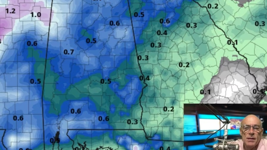
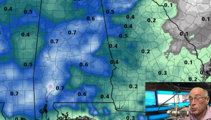
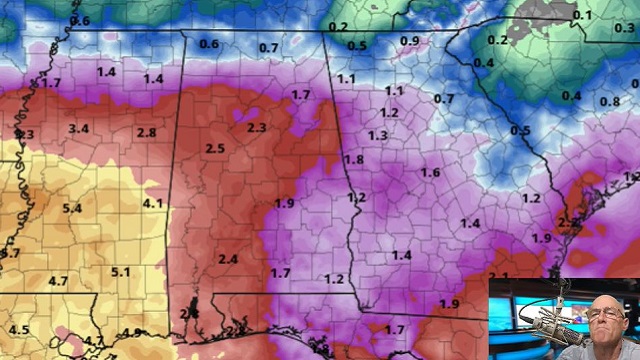
UNSETTLED WEATHER PATTERN CONTINUES: Large areas of rain are moving through central Alabama early this morning. We also note rain falling over the southern half of Mobile and Baldwin counties around daybreak. The weather won’t change much across Alabama through Wednesday — generally cloudy conditions with periods of rain and some thunder. On the positive side, we don’t expect any flooding or severe storms. And heat levels remain well below average for August in Alabama, with highs around 80 today, followed by low 80s Wednesday.
THURSDAY THROUGH THE WEEKEND: We will still mention scattered to numerous showers and thunderstorms Thursday, but showers should begin to thin out by Friday and the weekend as the air becomes more stable. The chance of any one spot seeing rain is 55-65% Thursday, dropping to near 30% Friday through Sunday. For the weekend the sky will be partly sunny, and most of the scattered showers and storms will come from around noon to midnight. As always in summer, there’s no way of knowing in advance exactly when and where the showers pop up; if you have something planned outdoors you simply have to watch radar trends. The high will be between 82 and 85 degrees Thursday, followed by upper 80s Friday through Sunday.
NEXT WEEK: We will keep the classic summer forecast going for the first half of the week with partly sunny days and scattered, mostly afternoon and evening showers and thunderstorms; there is some evidence drier air could push into the state late in the week as September arrives, but that is 10 days out and confidence is low.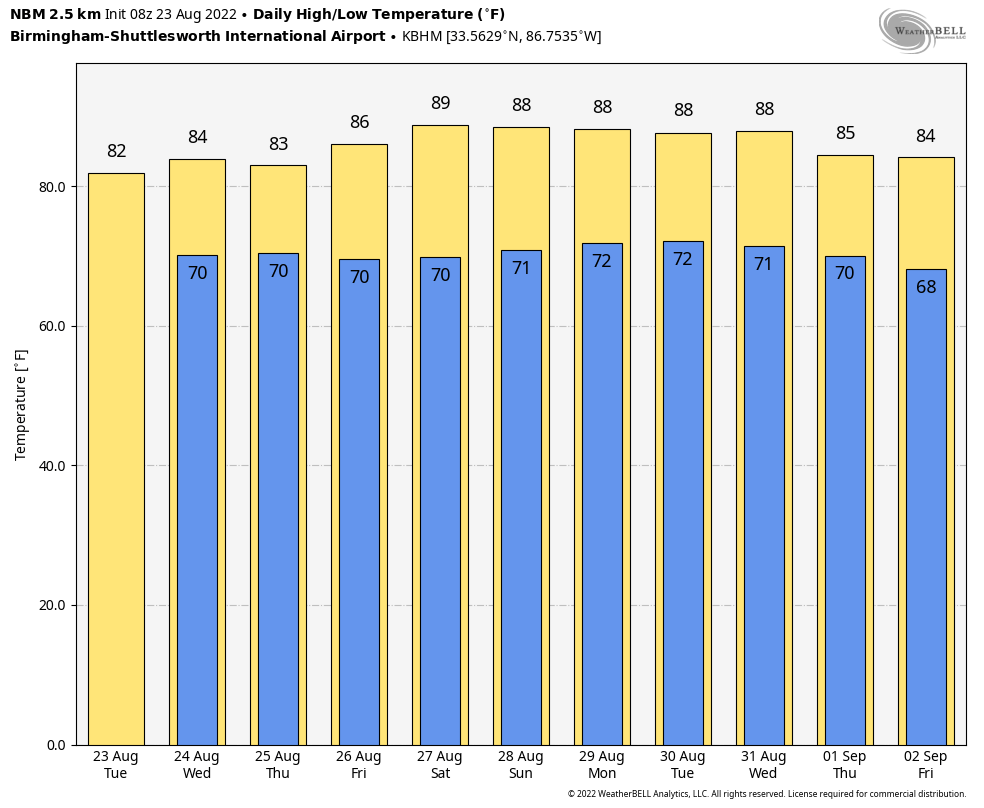 TROPICS: Shower activity has diminished somewhat associated with a weak tropical wave several hundred miles west of the Cabo Verde Islands. Environmental conditions appear only marginally conducive for gradual development during the next several days while the system moves westward to west-northwestward at 10 to 15 mph across the tropical Atlantic. The National Hurricane Center gives it only a 20% chance of development over the next five days. The rest of the Atlantic basin, including the Gulf of Mexico, remains very quiet.
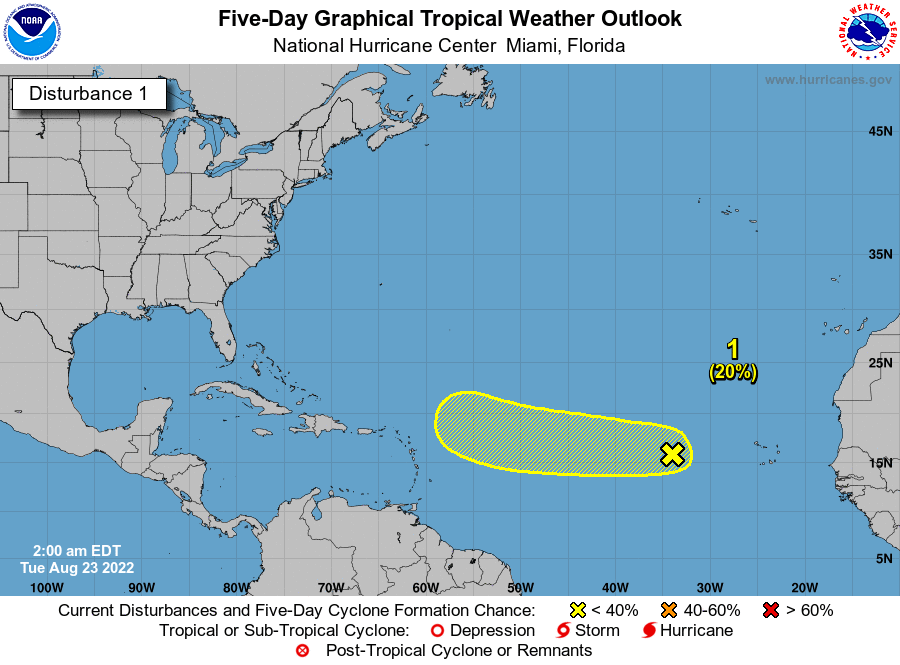 Another tropical wave will emerge off the coast of Africa in six to 10 days; global models suggest this one will have a higher chance of development.
ON THIS DATE IN 1933: A hurricane made landfall near Nags Head, North Carolina, and tracked up the Chesapeake Bay. The Chesapeake-Potomac hurricane moved over Norfolk, Virginia, and Washington, D.C. A seven-foot tide flooded businesses in Norfolk. It was described in the American Meteorological Society’s August 1933 weather review as “one of the most severe storms that have ever visited the Middle Atlantic Coast.”
ON THIS DATE IN 1992: While South Florida residents were preparing for Hurricane Andrew, folks in western Montana were dealing with early-season snowfall. Some snowfall amounts include 8.3 inches in Great Falls, 6.2 inches in Helena and 5.1 inches in Cut Bank. This is the first significant snowfall on record in western Montana in August.
ON THIS DATE IN 2005: Hurricane Katrina formed from Tropical Depression Twelve over the southeastern Bahamas. Katrina would become the costliest ($81.2 billion) and one of the deadliest hurricanes (1,836 lives) in U.S. history.
BEACH FORECAST: Click here to see the AlabamaWx Beach Forecast Center page.
For more weather news and information from James Spann and his team, visit AlabamaWx.