James Spann: Severe storms likely across Alabama late tonight
James Spann forecasts a risk of severe storms for Alabama late tonight into early morning from Alabama News Center on Vimeo.
ACTIVE WEATHER AHEAD: Alabama’s weather will stay warm and dry today, with a high in the low 80s this afternoon. Expect a mix of sun and clouds, with a gusty south wind by afternoon. Then, late tonight, an organized line of rain and thunderstorms will move into the state.
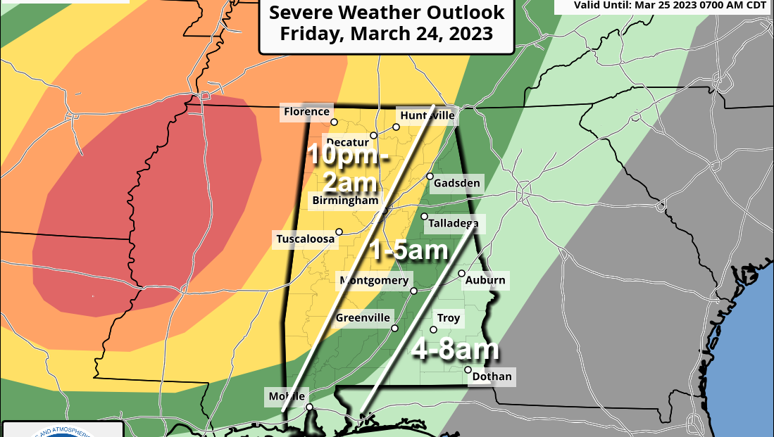
There is an enhanced risk (level 3 out of 5) of severe thunderstorms for the northwest corner of Alabama; a slight risk (level 2) extends as far east as Fort Payne, Clanton and Grove Hill. A marginal risk is defined down to Lake Martin, Greenville and Mobile.
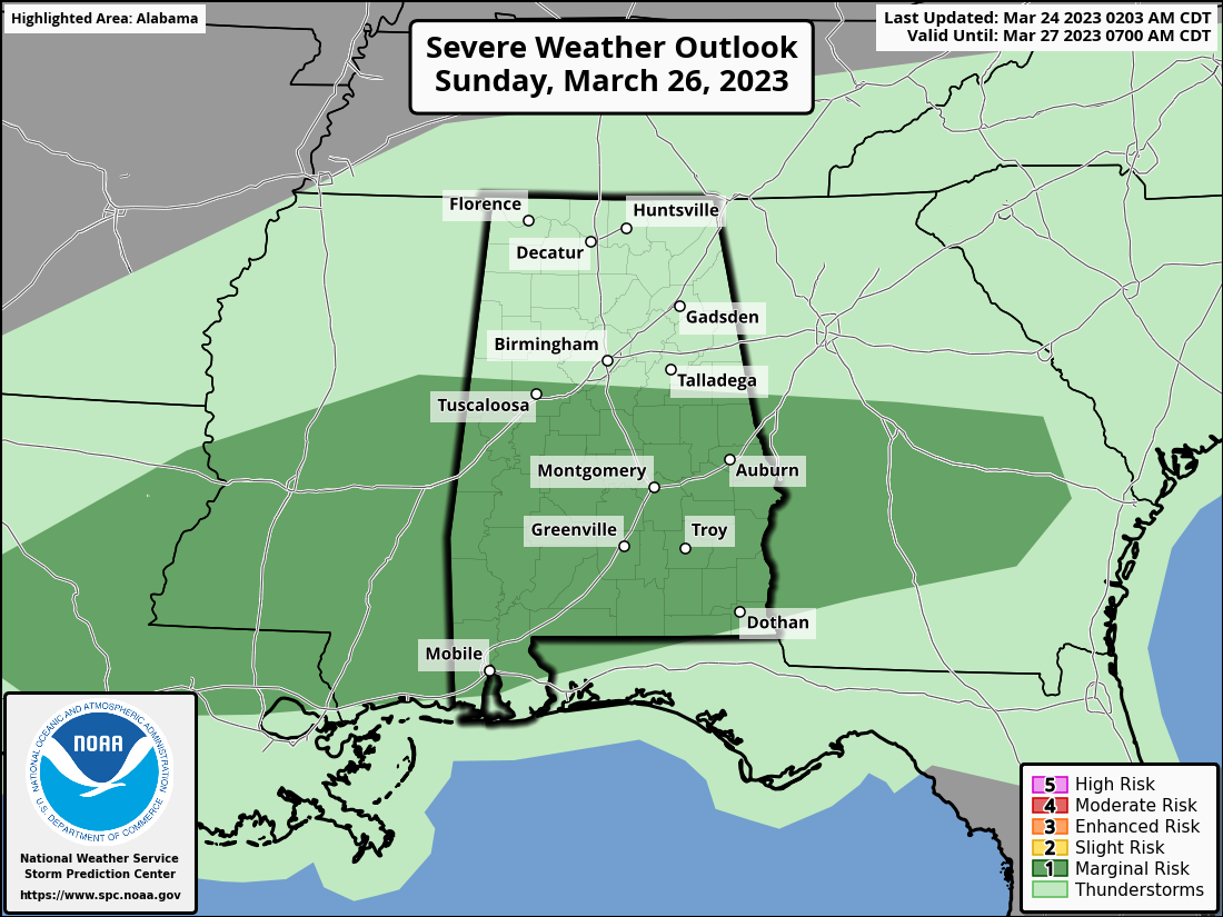
The outlook posted is valid through 7 a.m. Saturday; after that there is a marginal risk for the southeast counties of the state, including places like Troy, Eufaula and Dothan.
A broken line of strong to severe thunderstorms will move through the state late tonight and early Saturday. The main threat will come from strong, potentially damaging straight-line winds, but a few tornadoes are likely as well, especially in areas from Birmingham north and west.
With events like this it is very important that you have a way of hearing weather warnings in the middle of the night. The baseline for every home and business is a NOAA Weather Radio. Those will wake you up. Be sure your phone has Wireless Emergency Alerts enabled, and “Do Not Disturb” and “Sleep Mode” are not active. Know the safe place in your home and have helmets for everyone in the family there.
If you live in a mobile home, know the location of the nearest shelter (or business that is open 24/7 that can serve as a shelter), and the fastest way of getting there. Have transportation available. It sure isn’t convenient going to a shelter in the hours before dawn, but you can’t risk your life staying in a mobile home if you are in a tornado warning polygon.
Rain amounts will average one-half inch to 1 inch; for now, flooding is not expected.
REST OF THE WEEKEND: The sky becomes mostly sunny Saturday over much of Alabama as dry air returns; the day will be warm with a high in the low 80s in most communities. The front will stall out over south Alabama, drifting slowly northward Sunday. Showers and storms return Sunday, mainly over the southern two-thirds of the state (along and south of I-20). The air will be unstable, and strong storms are possible Sunday afternoon, with the main threats coming from strong winds and hail; the Storm Prediction Center has defined a marginal risk (level 1 of 5). The high will be in the upper 70s.
 NEXT WEEK: Showers and storms remain possible Monday and Tuesday, mainly over the southern two-thirds of the state. Dry, mild weather is expected Wednesday and Thursday before another round of showers and storms at the end of the week. Highs will be mostly in the 70s.
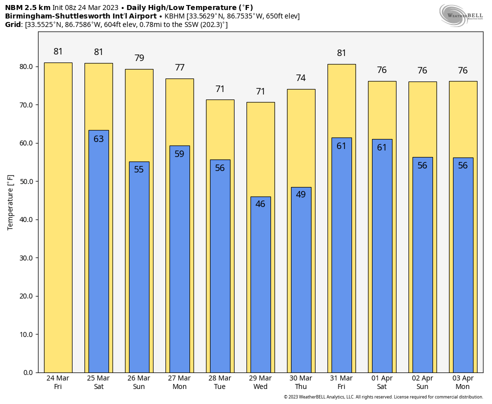
ON THIS DATE IN 1929: St. Louis, Missouri, soared to 92 degrees, its all-time record high for March.
ON THIS DATE IN 1975: “The Governor’s Tornado” hopscotched a 13-mile path across western Atlanta during the early morning, causing considerable damage to the Governor’s Mansion. Hundreds of expensive homes, businesses and apartment complexes were damaged. Total losses were estimated at $56 million. Three people lost their lives, and the F3 tornado injured another 152.
BEACH FORECAST: Click here to see the AlabamaWx Beach Forecast Center page.
For more weather news and information from James Spann and his team, visit AlabamaWx.


