James Spann: Multiple rounds of severe storms likely across Alabama today
James Spann forecasts risk of severe storms for Alabama today from Alabama News Center on Vimeo.
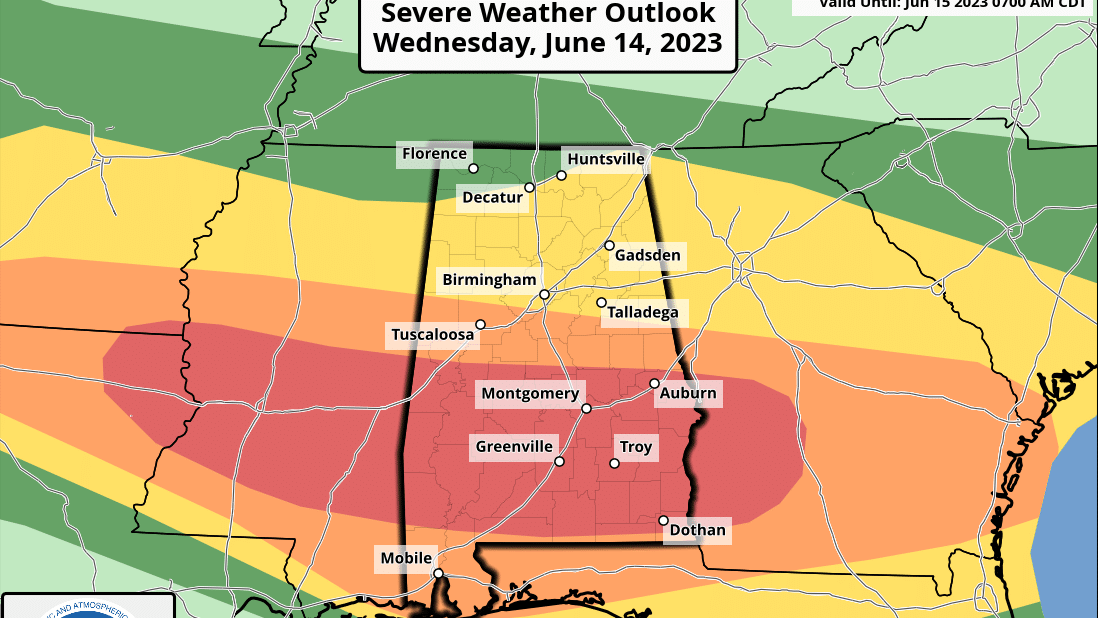
ACTIVE DAY: The weather pattern across Alabama today is more like spring. A band of strong winds aloft is undercutting an upper low over the eastern Great Lakes, and with good dynamic support we expect multiple rounds of strong to severe thunderstorms through tonight. The Storm Prediction Center (SPC) has now defined a moderate risk (level 4 of 5) for parts of central and south Alabama, including cities like Demopolis, Grove Hill, Selma, Monroeville, Montgomery, Greenville, Andalusia, Auburn, Troy, Eufaula and Ozark. Lower-level risks cover the rest of the state.
Heavier storms today will be capable of producing large hail and damaging winds. A few tornadoes are possible as well, mainly in the moderate risk area. The SPC has defined a hatched area through parts of central, south and southeast Alabama where a significant tornado (EF-2 or higher) is possible.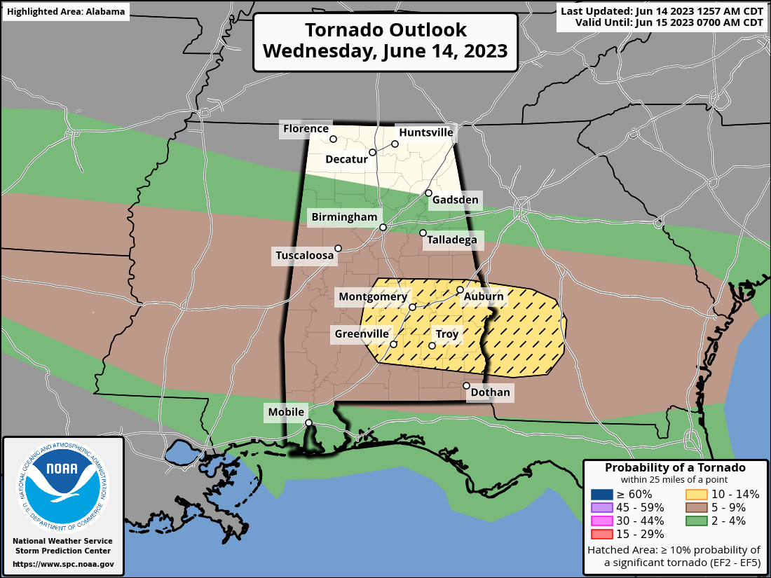 The higher risk of a tornado will come during the afternoon and evening. Be weather aware today and be sure you have a reliable way (never an outdoor siren) of hearing warnings if they are needed. It is very rare to have a tornado threat in Alabama in June without a tropical system involved, so this is an “out of season” event. I would also encourage you to pay close attention to severe thunderstorm warnings today since some thunderstorms could produce damaging winds in excess of 65 mph, which could produce damage like a small tornado.
A flash flood watch is in effect for much of Alabama south of I-20; rain amounts of 2-4 inches are possible through Friday, with totals exceeding 5 inches in many areas over the next seven days.
THURSDAY/FRIDAY: Scattered to numerous showers and storms are likely statewide Thursday, but the severe weather risk will be limited to the southern quarter of the state, and we are not expecting a tornado threat. The weather trends drier Friday, but widely scattered storms are possible, and they could be strong where they form.
THE ALABAMA WEEKEND: We will need to mention scattered showers and thunderstorms Saturday and Sunday, but the weekend won’t be a washout. The SPC has defined a risk of severe storms over northwest Alabama Sunday. There will be intervals of sun with highs in the 80s.
NEXT WEEK: For now, we expect fairly typical summer weather with partly sunny days and scattered, mostly afternoon and evening showers and thunderstorms daily. Highs will be between 88 and 91 degrees most days.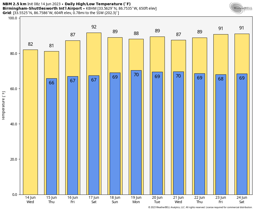
ON THIS DATE IN 1903: Major flash flooding along Willow Creek destroyed a significant portion of Heppner, Oregon. With a death toll of 247 people, it remains the deadliest natural disaster in Oregon.
For more weather news and information from James Spann and his team, visit AlabamaWx.


