James Spann: Some icing tomorrow – far north Alabama
THIS AFTERNOON: Temperatures are generally colder than forecast; again today some North Alabama communities are below freezing at mid-afternoon; temperatures are near 40 along the I-20 corridor. Clouds will increase this evening ahead of a wave that will bring the potential for some icy travel to far North Alabama tomorrow morning.
TOMORROW: The NWS Huntsville continues a “winter weather advisory” for Lauderdale, Limestone, Madison, Jackson, and DeKalb counties for tomorrow morning.

A band of light freezing rain will move through the Tennessee Valley early tomorrow, and with surface temperatures expected to be at or below freezing, that could bring some ice patches on roads and bridges. We should note some sleet and snow could also be in the mix, especially over the northeast corner of the state.
And, I can’t rule out a bit of freezing rain/ice patches on roads as far south as U.S. 278 early tomorrow… Hamilton to Cullman to Gadsden.
Understand this won’t be an especially high impact event, but it could very well bring some icy travel, and if you are driving through the northern third of the state tomorrow morning from 3:00 until 10:00, be aware of the potential.
We do not expect anything other that some light rain at times for Birmingham, Tuscaloosa, and Anniston, where temperatures will rise into the mid 40s by afternoon.
THURSDAY: A more potent storm system will impact the state with rain and a few thunderstorms. A deepening surface low will move from near Shreveport to Muscle Shoals; we might even see a few strong to severe thunderstorms in the warm sector. SPC has a “marginal” severe weather risk defined for much of Louisiana and Mississippi tomorrow, but for now we don’t expect any severe weather in Alabama. But, you clearly might hear some thunder. Rain amounts of 1 inch are likely by Thursday night, and temperatures will rise into the upper 50s Thursday afternoon.
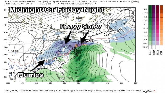
FRIDAY: The surface low moves northeast, setting up a whopper of a snow storm for the eastern U.S. Here in Alabama, strong northerly winds will develop, and temperatures should fall during the day, reaching the 30s by mid to late afternoon. Lingering light rain in the wrap around moisture on the west side of the low could very well change to light snow or snow flurries late Friday and Friday night, but for now the potential for any accumulation looks very low, and we project no impact.

SATURDAY: The day will be blustery and cold in Alabama; we won’t get out of the 30s, and we could see a few lingering snow flurries during the morning.
BLOCKBUSTER SNOW FOR THE EASTERN U.S.: Sure looks like somebody from West Virginia through Virginia and over to Maryland could see two feet of snow Friday into Saturday; the snow will continue northeast and impact other cities like Philadelphia, New York City, and Boston, although amounts should be lighter there. This will seriously impact travel, both on the roads, and at airports.

SUNDAY IN ALABAMA: The day will be sunny, and the afternoon will be warmer with a high in the low 50s. After starting the day down in the low 20s.
NEXT WEEK: Still seeing evidence of rain by Monday night or Tuesday, and another pop of colder air by Wednesday. See the Weather Xtreme video for maps, graphics, and more details.
WEATHER BRAINS: Don’t forget you can listen to our weekly 90 minute netcast anytime on the web, or on iTunes. This is the show all about weather featuring many familiar voices, including our meteorologists here at ABC 33/40.
CONNECT: You can find me on all of the major social networks…
Facebook
Twitter
Google Plus
Instagram
For more weather news and information from James Spann and his weather team, visit Alabama WX.


