James Spann: Big rains stay west of Alabama
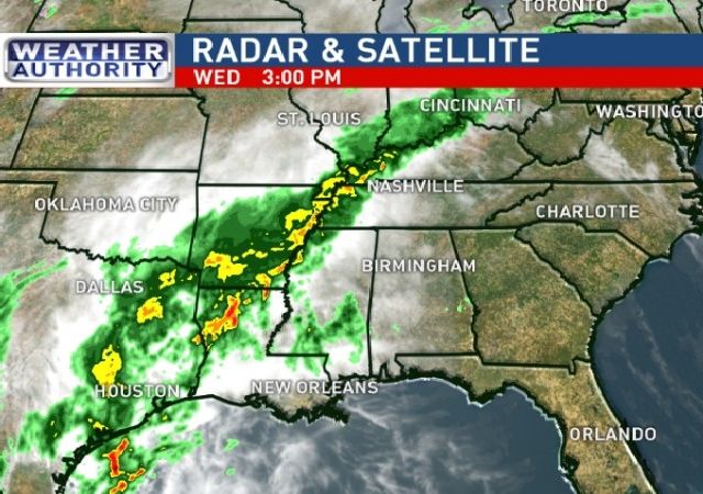
WARM MARCH DAY: Temperatures are in the 76-80 degree range across Alabama this afternoon with a good supply of sunshine…. while a serious flood situation continues to evolve to the west over parts of Louisiana, Arkansas, and East Texas…

TOMORROW: Models are keeping most of the widespread rain west of Alabama, and it sure looks like a decent part of the day will be dry for the state. A few showers are possible, mainly over the western counties, but nothing too widespread or heavy. Otherwise, we expect a mix of sun and clouds with a high in the mid to upper 70s again.
FRIDAY/SATURDAY: Models continue to trend drier, great news for those trying to hold outdoor events on these two days. While we will certainly mention the risk of showers, the most widespread rain stays west of our state, and we could very well see some sun at times. And, the weather stays warm for mid-March with potential for 80 degree warmth in a few spots both days.
SATURDAY NIGHT/SUNDAY: The upper trough that is current over Mexico will be filling and lifting out to the northeast, and it now looks like this might be the period with our best chance of showers. Maybe some thunder, but no severe weather issues, and the rain shouldn’t be all that heavy.
NEXT WEEK: A few isolated showers could linger on Monday, but Tuesday and Wednesday look warm and dry with highs between 76 and 80 degrees. See the Weather Xtreme video for maps, graphics, and more details.

AT THE BEACH: Dangerous rip tides are likely through the weekend (see the post below this one)… best chance of rain and storms tomorrow through the weekend will be around Gulf Shores, Dauphin Island, and Pensacola, best chance of seeing a decent amount of sunshine will be to the east, toward Fort Walton Beach, Destin and Panama City. See a very detailed Gulf Coast forecast here.
STORM SPOTTER TRAINING: We are offering basic SKYWARN training at several locations across North/Central Alabama in March, followed by the big event, Storm Spotter Xtreme on Saturday, April 9 at the BJCC from 9am to 2pm. This will feature both the basic and advanced SKYWARN classes, along with a session from Kevin Laws of the Birmingham NWS office. And, if you come, you get free admission to the Alabama International Auto Show, going on at the BJCC that same day. There is no cost and no need to register. Just show up with a curious mind. Kids 10 and older will also enjoy this if they love weather and want to learn more. Please help us make the severe weather warning process better!

WEATHER BRAINS: Don’t forget you can listen to our weekly 90 minute netcast anytime on the web, or on iTunes. This is the show all about weather featuring many familiar voices, including our meteorologists here at ABC 33/40.
CONNECT: You can find me on all of the major social networks…
Facebook
Twitter
Google Plus
Instagram
For more weather news and information from James Spann and his weather team, visit Alabama WX.