James Spann: One more dry day; stormy by Thursday in Alabama
BLUE SKY AND SUNSHINE: What a delightful day for Alabama… a sunny sky with temperatures in the low 70s in most places this afternoon. Doesn’t get much better.
We stay dry tomorrow with a mix of sun and clouds; the high will be in the mid 70s. To the west, severe storms are possible in a broad zone from Houston and Lake Charles north through places like Tulsa, Little Rock, Kansas City, and up to Des Moines.
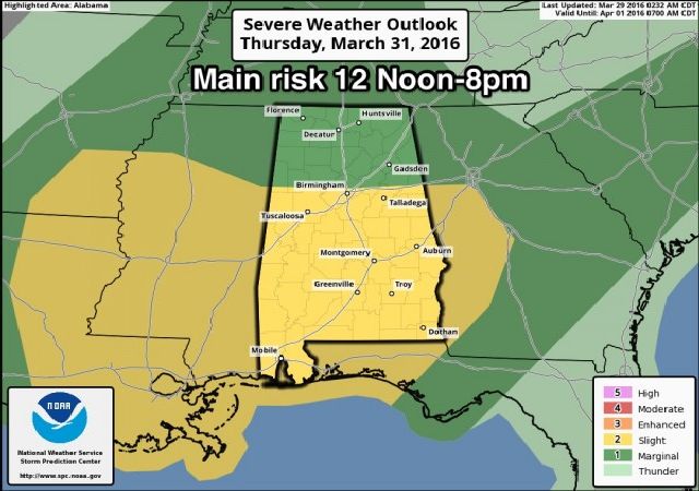
SEVERE WEATHER THREAT THURSDAY: A deep surface low will be over Michigan, with a trailing front down to about Memphis and Dallas at midday. A moist, unstable airmass will cover Alabama… looks like the highest instability values we have experienced all year with surface based CAPE values exceeding 2,000 j/kg in many places by afternoon. If we get a break in the rain, and the sun breaks out for a while, surface temperatures could approach 80 degrees by afternoon with dewpoints in the upper 60s.
But, the best dynamics will be lifting away at the time when instability values are at a maximum, meaning the system could be a little “out of phase”. Still, forecast shear and wind field values suggest we could see severe thunderstorms. SPC has the standard “slight risk” up for that part of Alabama south of a line from Millport to Birmingham to Anniston, with a “marginal risk” to the north.

Don’t be surprised if this outlook changes early tomorrow with the new “Day 2” will be issued.
TIMING: The main window for severe storms Thursday will come from roughly 12:00 noon through 8:00 p.m.
MODES: Stronger storms will be capable of producing large hail and strong, possibly damaging winds. There is a conditional tornado threat; we will be able to better define that risk tomorrow after a few more model runs.
RAIN AMOUNTS: Models hint the heaviest rain could be a little north and west of here, with 2-4 inches likely over North Mississippi. For places like Birmingham, Tuscaloosa, Anniston, and Gadsden, amounts of 1-2 inches are expected. Some flash flooding issues are possible; parts of Mississippi are already under a flash flood watch.
The bottom line is that there are still some questions concerning the overall setup for Thursday, so keep an eye on the blog for forecast changes.
FRIDAY: Looks like a clearing sky with a high in the 60s for most places, but communities south and east of Birmingham could reach the 70s.
THE ALABAMA WEEKEND: Very nice spring weather, with sunny pleasant days and clear cold nights. Highs in the mid 60s Saturday, and upper 60s Sunday. The latest GFS is showing lows in the 38-43 degree range both mornings; highest frost potential will come early Sunday when the wind will be near calm. It won’t be a widespread, killing type frost, but colder pockets should see frosty conditions with mid 30s.
NEXT WEEK: The weather stays dry with a warming trend for the first half of the week; a cold front will bring a chance of showers/storms by Thursday or Friday, but for now it doesn’t look like a severe weather setup. See the Weather Xtreme video for maps, graphics, and more details.
AT THE BEACH: Clouds increase tomorrow along the coast from Panama City Beach over to Gulf Shores, and showers and storms are likely Thursday and Friday. Drier air returns Saturday… See a very detailed Gulf Coast forecast here.
STORM SPOTTER TRAINING: Storm Spotter Xtreme is coming up Saturday, April 9 at the BJCC from 9am to 2pm. This will feature both the basic and advanced SKYWARN classes, along with a session from Kevin Laws of the Birmingham NWS office. And, if you come, you get free admission to the Alabama International Auto Show, going on at the BJCC that same day. There is no cost and no need to register. Just show up with a curious mind. Kids 10 and older will also enjoy this if they love weather and want to learn more. Please help us make the severe weather warning process better!
WEATHER BRAINS: Don’t forget you can listen to our weekly 90 minute netcast anytime on the web, or on iTunes. This is the show all about weather featuring many familiar voices, including our meteorologists here at ABC 33/40.
CONNECT: You can find me on all of the major social networks…
Facebook
Twitter
Google Plus
Instagram
For more weather news and information from James Spann and his weather team, visit Alabama WX.


