James Spann: Storms likely for Alabama around Monday night; light rain tomorrow
MACKEREL SKY: We have a field of altocumulus clouds across Alabama this afternoon, ahead of a storm system to the west. A beautiful November sky. The photo below is from @ace123michael.

Temperatures are in the 60s and the low levels remain extremely dry, with dew points between 5 and 15 degrees.
TOMORROW: A short wave aloft will push showers into Alabama during the afternoon. The Storm Prediction Center suggests some thunder is possible over North and West Alabama, but the air will be stable and we won’t expect any severe weather problems. Showers will remain possible through tomorrow night, but this will be a light rain event with amounts generally around one-tenth of an inch. Some spots over Northwest Alabama could see a quarter of an inch. this kind of rain certainly isn’t significant considering the exceptional drought we are in, but it will help forestry officials and their constant battle against wildfires.
The main window for showers will come from noon tomorrow through 6 a.m. Thursday.
THANKSGIVING DAY: It is possible we could see a little light rain lingering early Thursday morning over far East Alabama, but the showers should be mostly over by 6 a.m. Morning clouds will give way to a partly sunny afternoon, and the high will be close to 70 degrees. A very comfortable day.
FRIDAY AND THE WEEKEND: Mostly sunny days, fair nights. The high Friday will be close to 70, but temperatures will drop about 10 degrees Saturday with a surge of cooler air; the high will be close to 60 for most communities. Many spots will see a light freeze early Sunday with lows in the upper 20s and low 30s.
IRON BOWL: A beautiful day for football in Tuscaloosa Saturday. For our state’s biggest game of the year (Auburn at Alabama, 2:30 p.m. kickoff at Bryant Denny Stadium), the sky will be sunny with temperatures falling from 61 degrees at kickoff into the 50s during the second half.
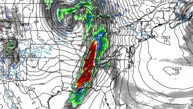
STORMY WEATHER RETURNS: A dynamic storm system will impact Alabama early next week; we have excellent model agreement. A vigorous upper trough will spin up a deep surface low over the Upper Midwest Monday, and the trailing cold front will bring rain and strong storms to the Deep South. For now it looks like the main impact in Alabama will come Monday night. We will need to monitor this system for severe weather potential; on the positive side, rain amounts of one-half to 1 inch look likely.

Active weather should continue into December; ensemble guidance from the reliable European global model is still showing almost 8 inches of rain around here through early January.
AT THE BEACH: Mostly sunny days and fair nights on the coast from Panama City Beach to Gulf Shores through the weekend, with highs mostly in the 70s. See a detailed Gulf Coast forecast here.
EYES ON OTTO: The tropical storm in the far southwest Caribbean is expected to become a hurricane soon; it moves into Central America Thanksgiving Day, and is far from the U.S. The rest of the Atlantic basin is quiet.
WEATHER BRAINS: You can listen to our weekly 90-minute netcast anytime on the web, or on iTunes. This is the show all about weather featuring many familiar voices, including meteorologists at ABC 33/40.
CONNECT: You can find me on all of the major social networks:
Facebook
Twitter
Google Plus
Instagram
For more weather news and information, visit AlabamaWX.


