James Spann: Alabama gets light refreshment before next week’s storm
RADAR CHECK: So far, just spotty light rain has been falling over Northwest Alabama; elsewhere we have a mix of sun and clouds, with temperatures between 67 and 70 in most places. Very low dewpoints and dry air have prevented much rain today, but with moist air advecting into the state from the west tonight, we still expect periods of light rain with an approaching upper trough. Model guidance suggests rain amounts from 0.05 to 0.15 inches — not meaningful when it comes to our exceptional drought, but it will help the wildfire situation a bit just to get a little water in the ground.
Also, look out for some dense fog developing late tonight and tomorrow morning.
DROUGHT MONITOR: New data released this morning shows 35 percent of Alabama in “exceptional drought” conditions.

THANKSGIVING DAY: Light rain could linger over East Alabama early tomorrow morning, but morning clouds will give way to some afternoon sunshine, and the high will be close to 70 degrees. A very comfortable day.
FRIDAY AND THE WEEKEND: Mostly sunny days and fair nights. The high Friday will be close to 70; then, expect 60s Saturday and Sunday as slightly cooler air slips into the state.
IRON BOWL: A beautiful day for football in Tuscaloosa Saturday. For our state’s biggest game of the year (Auburn at Alabama, 2:30 p.m. kickoff at Bryant Denny Stadium), the sky will be sunny, with temperatures falling from 64 degrees at kickoff into the 50s during the second half.
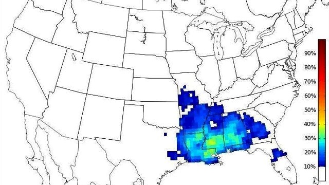
STORMY WEATHER RETURNS NEXT WEEK: A dynamic storm system will impact Alabama early next week. Global model data suggests the main threat of rain and storms will come Tuesday and Tuesday night. Prior to the storms moving in, we will have a “wide open” Gulf of Mexico Monday, pushing dew points up into the 60s and setting up a very moist, unstable environment, something we haven’t seen here since summer.
Using CIPS Analog Guidance (looking at past events with similar surface and upper air setups), there is concern this could be a high-impact event with the dual threat of severe thunderstorms and heavy rain. Too early to be specific, but something to watch in coming days.

Another big rain seems possible toward the end of the week and the following weekend.
AT THE BEACH: Mostly sunny days and fair nights on the coast from Gulf Shores to Panama City Beach through the weekend, with highs in the 70s. See a detailed Gulf Coast forecast here.
OTTO: The system in the far southwest Caribbean was downgraded to a 70 mph tropical storm this morning, but is expected to regain hurricane strength tonight before moving into Central America tomorrow. It will then emerge into the eastern Pacific Friday and will get a new name.
WEATHER BRAINS: You can listen to our weekly 90-minute netcast anytime on the web, or on iTunes. This is the show all about weather featuring many familiar voices, including meteorologists at ABC 33/40.
CONNECT: You can find me on all of the major social networks:
Facebook
Twitter
Google Plus
Instagram
For more weather news and information, visit AlabamaWX.


