James Spann: Warm front creeping northward through Alabama, but won’t last long
ON THE MAPS: A warm front is near I-20 and moving slowly northward. North of the warm front, we have cool temperatures (mostly 50s), low clouds, fog and drizzle. South of the front, rain and storms continue across much of South Alabama; the heaviest rain is south of U.S. 80 and west of I-65 at mid-afternoon.
The Storm Prediction Center maintains a “marginal risk” of severe storms for far Southwest Alabama through the evening.

Rain tapers off across the state tonight as the first of two surface fronts slips through. Tomorrow for now looks cool and dry for the northern half of the state; the sky becomes partly sunny with a high in the mid to upper 50s.
MUCH COLDER THURSDAY/FRIDAY: Arctic air returns to Alabama Thursday. Despite a sunny sky, most communities around here won’t get past the mid 40s with a chilly north breeze. By Friday morning, a significant freeze is likely with mid 20s; colder pockets will be close to 20 degrees. Then, during the day Friday, the sky will be mostly sunny with a high between 47 and 51 degrees.
THE ALABAMA WEEKEND: Southerly winds return to Alabama Saturday, pushing moisture northward from the Gulf of Mexico, and also bringing mild temperatures back quickly. Some spots could touch 70 degrees Saturday afternoon, and we expect developing rain showers during the day as moisture levels rise.
Rain and thunderstorms become more widespread Saturday night and Sunday with the approach of another Arctic front.
Sunday is going to be one of those very interesting weather days, with two potential issues.
STRONG STORMS: The first is the possibility of strong storms over the southern half of the state late Saturday night and Sunday. Unstable air will move as far north as I-20, but the best chance of strong thunderstorms most likely will come over the southern counties of Alabama Sunday. A severe storm can’t be ruled out as temperatures rise into the 70s and dewpoints surge toward 60.
WINTRY MIX? While South Alabama is in the 70s with strong thunderstorms, temperatures over North Alabama will begin to fall during the day Sunday in the wake of the Arctic front, and the Global Forecast System hints that the rain could taper off into a “wintry mix” of freezing rain, sleet and maybe even a snowflake or two. The best chance of this would be along and north of U.S. 278 (Hamilton to Cullman to Gadsden), but we stress that at this point we expect LITTLE OR NO IMPACT. This could change, of course, but the thermal fields are pretty marginal for wintry issues, and the reliable European model (ECMWF) shows mostly rain.
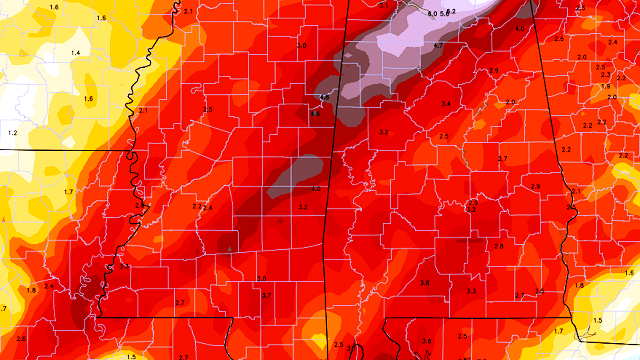
NEXT WEEK: The latest GFS now keeps rain going over East and South Alabama Monday, and that rain surges northward Monday night and Tuesday as an unsettled southwest flow continues across the Deep South. In fact, the week in general looks pretty wet, with the GFS suggesting 3 to 6 inches of rain for much of Alabama over the next 10 days.

As we approach Christmas, temperatures look like they will be pretty close to average for late December, with highs mostly in the 50s. No sign of any Arctic blasts for now around the weekend of Dec. 24-25.
WEATHER BRAINS: You can listen to our weekly 90-minute netcast anytime on the web, or on iTunes. This is the show all about weather featuring many familiar voices, including meteorologists at ABC 33/40.
CONNECT: You can find me on all of the major social networks:
Facebook
Twitter
Google Plus
Instagram
For more weather news and information, visit AlabamaWX.


