James Spann: Severe weather possible in Alabama today, tonight
James Spann: Risk of severe weather today, tonight for most of Alabama from Alabama NewsCenter on Vimeo.
Welcome to the New Year. The weather folks will be very busy over the next seven days, with severe weather potential today and a chance of winter mischief as the weekend begins. The clear focus today has to be on the thunderstorm situation for the next 18 to 24 hours.
ON THE MAPS: A surface low is developing west of the state, supported by an upper trough lifting out of Texas. From the low, a warm front extends eastward through Central Alabama. This warm front will slowly lift northward today, bringing high dew points and unstable air to the state, and setting the stage for strong to severe thunderstorms this afternoon and tonight.
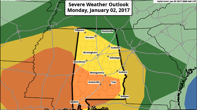
The Storm Prediction Center maintains an “enhanced risk” of severe storms south of a line from Eutaw to Montgomery to Ozark. The standard “slight risk” covers the rest of the state, except the northeast corner.

TIMING: Severe storms could break out as early as this afternoon, especially over the western counties of the state, but it seems like the core threat will come from 4 p.m. until midnight for North/Central Alabama. The risk of severe storms will linger past midnight over Southeast Alabama.
THREATS: The main risk in North Alabama will come from gusty straight-line winds and hail, although an isolated tornado can’t be ruled out. But the core tornado threat will be in the “enhanced risk” area of West and South Alabama tonight, where a better combination of instability and shear will be found. The updraft helicity product (via the high-resolution North American Mesoscale model) shows areas where rotating updrafts are more likely, and accordingly a higher tornado risk.

The updraft helicity product has performed well in other severe weather episodes in Alabama in recent years.
RAIN: Rain amounts of 1 to 2 inches are likely over the next 24 hours, with potential for more in spots. A flash flood watch is in effect for about the southern quarter of Alabama.
CALL TO ACTION: Today is a holiday for most, meaning many families will be traveling and not in their usual place on a Monday. So, be sure you have a way of hearing severe weather watches and warnings. At home, you need a properly programmed NOAA Weather Radio with a battery backup. On your phone, for warnings we recommend WeatherRadio by WDT. You can watch our live severe weather coverage on the free ABC 33/40 app. Here are the links:
ABC 33/40 iOS version for iPhones and iPads
ABC 33/40 Android version for Android phones and tablets
Review your action plan in case a tornado warning polygon includes your home. Get in a small room, on the lowest floor, away from windows and near the center of the house. You do NOT have to be underground. Never be in a car or mobile home.
TOMORROW THROUGH THURSDAY: Rain ends very early tomorrow, but clouds will linger much of the day, with temperatures in the 60s. Colder air invades Alabama Wednesday; looks like we hold in the 40s most of the day with a chilly north wind. By Thursday, as Arctic air settles into the state, we will have a hard time getting out of the 30s with a mix of sun and clouds.
POTENTIAL WINTER MISCHIEF: Let me say up front we will have little confidence in a forecast solution for Friday and Saturday until we get past the event today. But global models (both the Global Forecast System and the European) are suggesting potential for wintry precipitation across North Alabama at some point Friday night or Saturday. Snow lovers will love the latest GFS run, which is very aggressive, but the European seems to be more realistic at this point. Using the ensemble approach, the mean is printing just under 1 inch of snow for Birmingham Friday night and early Saturday morning (green bars on the graph below).

Just be aware that winter weather could affect the northern third of Alabama Friday night into at least part of the day Saturday; we will be able to be much more specific tomorrow.
Sunday looks cold and dry, followed by a warming trend early next week.
WEATHER BRAINS: You can listen to our weekly 90-minute netcast anytime on the web, or on iTunes. This is the show all about weather featuring many familiar voices, including meteorologists at ABC 33/40.
CONNECT: You can find me on all of the major social networks:
Facebook
Twitter
Google Plus
Instagram
For more weather news and information, visit AlabamaWX.


