James Spann: Here’s your winter storm watch for Friday in Alabama
COLD TODAY, MUCH COLDER FRIDAY: The one thing for sure is that the weather in Alabama will be very cold Friday through the weekend. Most North Alabama communities are only in the 40s this afternoon, and the second phase of the big chill arrives Friday; many places across North Alabama will stay below freezing all day. The big question, of course, involves potential for winter mischief along with the cold.
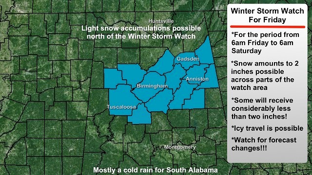
WINTER STORM WATCH: The National Weather Service Birmingham has issued a winter storm watch for Friday for Tuscaloosa, Bibb, Fayette, Walker, Jefferson, Shelby, St. Clair, Blount, Etowah, Cherokee, Talladega and Clay counties.

The watch is in effect from 6 a.m. Friday through 9 a.m. Saturday.
The criteria for a winter storm watch here is 2 inches of snow, and there is a chance some communities in the watch area could very well get 2 inches of snow by Friday night. But understand that many places in the watch area won’t get 2 inches.

To the north, over the Tennessee Valley, any accumulation of snow Friday should be light.
And to the south, if you are in places like Montgomery, Selma, Auburn, even Greenville and Troy, there is some chance you might deal with a “wintry mix” of sleet and freezing rain Friday night.
IMPACT: With relatively light snow expected, we don’t expect any power outages. The main issue is the potential for icy travel, possibly beginning as early as Friday morning, when temperatures will be in the upper 20s. Even during the midday Friday, it will be hard for us to rise above 32 degrees, so icy spots are very possible, especially on bridges and overpasses during the day where snow falls.
The chance of icy travel continues into Friday night, and as cold air drops southward, understand we could see some sleet/freezing rain issues down into South/Central Alabama (but probably no snow there).
Here is a look at the probability of more than 1 inch of snow from 6 a.m. Friday through 6 a.m. Saturday, if you are traveling.

Wintry precipitation will end very early Saturday morning as the wave in the Gulf of Mexico lifts out.
IMPORTANT: There is still considerable model disagreement concerning potential for snow Friday; the winter storm watch was issued as a “course of least regret.” The Global Forecast System model is the most aggressive; other models show much lighter amounts, so there will be some places in the winter storm watch area that receive very little snow.
More forecast changes are a good possibility, so please check in often for updates as we approach the event.
VERY COLD WEEKEND: The sky becomes partly sunny Saturday, and Sunday should be mostly sunny, but very cold Arctic air stays in place. The high Saturday will be in the 30s, and the latest GFS run is printing a low of 15 degrees for Birmingham early Sunday morning. Monday morning should be just as cold.
A warming trend begins early next week, and rain returns to the state by Tuesday night and Wednesday.
WEATHER BRAINS: You can listen to our weekly 90-minute netcast anytime on the web, or on iTunes. This is the show all about weather featuring many familiar voices, including meteorologists at ABC 33/40.
CONNECT: You can find me on all of the major social networks:
Facebook
Twitter
Google Plus
Instagram
For more weather news and information, visit AlabamaWX.


