James Spann: Strong, possibly severe storms to cross Alabama today
James Spann: Stormy day ahead for much of Alabama from Alabama NewsCenter on Vimeo.
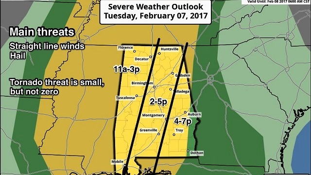
ACTIVE DAY: Showers have formed over West Alabama early this morning, and with the approach of an upper trough we expect rain and storms statewide later today. The Storm Prediction Center has put most of the state in the standard “slight” risk of severe storms.

It still seems like things are a bit out of phase today, with the best instability to the west and south, removed from the dynamic lift. But, with a low-level jet of more than 50 knots and a decent amount of low-level bulk shear, there is certainly a good chance of organized strong thunderstorms across Alabama today.
TIMING: For West Alabama, the main window for strong storms will come from 11 a.m. to 3 p.m.; for the central counties 2 to 5 p.m., and for East and Southeast Alabama 4 to 7 p.m. This will be a daytime event for a change.
THREATS: The primary threats are strong thunderstorm straight-line winds and hail. The tornado threat is low, but it is not zero. Even though this is a rather low-end severe weather threat, everyone still needs to pay attention. When it comes to thunderstorms, expect the unexpected.
RAIN: Rain amounts of one-half to 1 inch are likely, and flooding is not expected.
TONIGHT: The weather should be fairly calm — mostly cloudy, with only widely scattered showers.
TOMORROW: The surface front will pass through, but the severe weather threat is very conditional. A capping inversion could very well keep most of the day storm-free, but if a storm can punch through, then it could be strong, with potential for some hail and gusty winds. SPC has a decent part of the state in a “marginal” risk for severe weather.

Tomorrow will be a warm day for February, with a high in the low 70s in most places.
TURNING COLDER THURSDAY/FRIDAY: The sky becomes mostly sunny Thursday following the front, but the day will be breezy and much colder. Not sure we get out of the 40s Thursday afternoon, and a north wind of 10 to 20 mph will make it feel colder. We drop into the 25- to 30-degree range early Friday morning, and we expect a cool, dry day Friday with lots of sun and a high in the mid 50s.
THE ALABAMA WEEKEND: Saturday looks dry for most of the state, although a few isolated showers could form over the northern counties. With a mix of sun and clouds, we project a high in the upper 60s Saturday afternoon. Sunday will be mostly cloudy, but any showers should be light and fairly widely spaced. Sunday’s high will be close to 70 degrees.
NEXT WEEK: A deep upper low will lift out of the Southwest and bring rain and storms to Alabama by Wednesday or Thursday, followed by sharply colder air.
WEATHER BRAINS: You can listen to our weekly 90-minute netcast anytime on the web, or on iTunes. This is the show all about weather featuring many familiar voices, including meteorologists at ABC 33/40.
CONNECT: You can find me on all of the major social networks:
Facebook
Twitter
Google Plus
Instagram
Pinterest
Snapchat: spannwx
For more weather news and information, visit AlabamaWX.


