James Spann: Rain returns to Alabama Saturday night, then colder air
James Spann: Get set for rain, cool weather, possible North Alabama snow this weekend from Alabama NewsCenter on Vimeo.
A BIT COOLER TODAY: The band of strong to severe storms that moved through during the pre-dawn hours is now over far Southeast Alabama. Drier air is returning to the northern half of the state, and we expect a good supply of sunshine today with a high back in the 60s, about 10 degrees cooler than yesterday.
Tonight will be clear and cold, with a low in the mid 30s early tomorrow morning.
FAST-PACED CHANGES FOR THE WEEKEND: We begin the day tomorrow with some sun, but clouds return quickly by afternoon, and rain will become widespread tomorrow night into early Sunday morning. No severe weather worries this time with a cold, stable airmass in place; the main window for rain comes from roughly 6 p.m. tomorrow through 8 a.m. Sunday. Rain amounts of around one-half inch are likely.
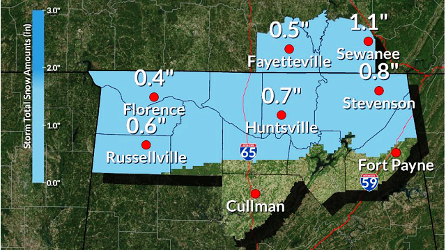
NORTH ALABAMA SNOW? As colder air filters into the state early Sunday, rain will change to light snow over far North Alabama. The National Weather Service in Huntsville suggests some communities across the Tennessee Valley could see up to one-half inch of snow.

Temperatures along and north of the Tennessee River will drop into the upper 20s early Sunday morning, so some icy travel is very possible there, and northward up into Tennessee, where 1-2 inches of snow is expected in some communities.

Around Birmingham, the rain ends early Sunday, and the day will be breezy and colder with a high in the low 50s. Some clearing is possible by mid to late afternoon.
NEXT WEEK: An Alberta clipper will bring clouds back into the state Monday, and the latest Global Forecast System suggests some light rain is possible Monday afternoon and Monday night. There won’t be much moisture to work with, so rain amounts, if any, should be pretty light. The high Monday afternoon will be in the upper 50s.
Then, another shot of colder air blows into the state Tuesday; some morning snow flurries are possible across the northern counties of Alabama, and temperatures won’t get out of the 40s with a chilly north wind.
A significant freeze is likely early Wednesday morning, with lows down in the mid 20s; it is very possible some of the colder communities across North/Central Alabama could see upper teens.
WEATHER BRAINS: You can listen to our weekly 90-minute netcast anytime on the web, or on iTunes. This is the show all about weather featuring many familiar voices, including meteorologists at ABC 33/40.
CONNECT: You can find me on all of the major social networks:
Facebook
Twitter
Google Plus
Instagram
Pinterest
Snapchat: spannwx
For more weather news and information, visit AlabamaWX.


