James Spann: Dry today, stormy tomorrow in Alabama
James Spann: Stormy weekend ahead for Alabama from Alabama NewsCenter on Vimeo.
ONE MORE DRY DAY: We will project a partly sunny sky across Alabama today, with a high in the 70s this afternoon. While we enjoy a quiet day, severe storms are possible west of the state as an upper trough lifts out of the Rockies. Places like Tulsa, Shreveport, Houston and Little Rock will have a risk of severe storms this afternoon and tonight.
ACTIVE DAY TOMORROW: A surface low will be near St. Louis tomorrow with Alabama in a moist, unstable airmass. The Storm Prediction Center maintains a “slight risk” of severe storms over the western side of Alabama, with a “marginal risk” to the east.

It won’t rain all day tomorrow, but when storms do pass through they will pack a punch.
TIMING: We will certainly have a chance of showers and possibly a thunderstorm tomorrow morning, but the core threat of strong to severe storms will come from noon until 9 p.m.
THREATS: Seems like damaging straight-line winds will be the main issue; the highest shear values are displaced from the highest instability, which should mitigate the overall tornado threat. But an isolated tornado can’t be totally ruled out, especially over far West Alabama tomorrow afternoon. Stronger storms could also produce some hail.
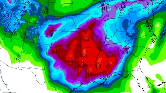
RAIN: Rain totals should be in the one-half to 1-inch range; flooding is not expected.
SUNDAY: The surface low weakens and lifts northeast, but a moist, unstable airmass will remain over Alabama. We will forecast a mix of sun and clouds, and we will need to introduce the chance of a few widely scattered showers and storms during the afternoon and evening due to the instability. In fact, the SPC has the northeast corner of Alabama in a “marginal risk” for severe storms Sunday afternoon.

NEXT WEEK: Another upper trough/surface low will bring the chance of strong to severe storms to Alabama Monday, followed by yet another opportunity later in the week. The latest Global Forecast System hints that strong/severe storms will be possible Thursday afternoon and Thursday night. Understand in an active pattern like this we simply need to take the waves one at a time; it is very hard to determine the overall magnitude of the threats and the timing several days out.
PUT AWAY THE WINTER CLOTHES? While we don’t see any sign of a late-season cold snap into early April, I still expect one more flush of colder air toward mid April that will bring the threat of frost or a freeze.
STORM SPOTTER TRAINING: We will be on the road through early April offering free storm spotter classes. We need more trained spotters in Alabama. By attending you can make the severe weather warning process better. No need to register; just come with a curious mind. And there is no age limit; kids who love weather will enjoy it. You will never look at a storm the same again. Next week we are in Oxford Tuesday (at the Oxford Civic Center) and Jasper Thursday (at the Jasper Civic Center).
WEATHER BRAINS: You can listen to our weekly 90-minute netcast anytime on the web, or on iTunes. This is the show all about weather featuring many familiar voices, including meteorologists at ABC 33/40.
CONNECT: You can find me on all of the major social networks:
Facebook
Twitter
Google Plus
Instagram
Pinterest
Snapchat: spannwx
For more weather news and information, visit AlabamaWX.


