James Spann: Storms return to Alabama Sunday night
James Spann: Risk of severe storms late in the weekend for Alabama from Alabama NewsCenter on Vimeo.
HEATING UP: With a partly sunny sky today, we expect a high in the mid 80s across much of North/Central Alabama; the average high for April 28 is 77. An isolated shower could fire up late this afternoon as the air becomes unstable, but the chance of any one spot getting wet is only about 1 in 10.
Both the North American Mesoscale and the Global Forecast System models are suggesting a high at 90 degrees for Birmingham tomorrow; if we can achieve that level, it will beat the old record high for April 29 of 89, set in 1915. We will mention a chance of widely scattered thunderstorms tomorrow afternoon and evening, as moisture levels will be a tad higher. Otherwise, we expect a mix of sun and clouds tomorrow.
To the west, active storms will fire up across the ArkLaTex region tomorrow and tomorrow night, and those will move into Alabama before the weekend is over.
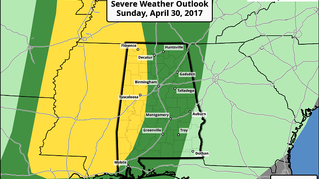
SUNDAY: It will be a warm and windy day; much of the daytime should be dry, with only isolated showers. Thunderstorms will push into Alabama Sunday night ahead of a cold front, and those could pack a punch. The Storm Prediction Center has the western quarter of Alabama in the standard “slight risk” Sunday night, with a “marginal risk” of severe weather for much of the rest of the state.

It seems like the main limiting factor for severe weather Sunday night will be the lack of surface-based instability; CAPE values are forecast to be under 500 j/kg as the storms move through.
The main window for thunderstorms will come from 6 p.m. Sunday through 6 a.m. Monday. The main risk will come from strong, gusty straight-line winds, although some hail is possible. For now the threat of tornadoes looks rather low. We will keep a close eye on things over the weekend as the event gets closer.
Rain amounts of 1 to 2 inches are likely Sunday night; not bad news, since much of North/Central Alabama is still in drought.

NEXT WEEK: Monday will feature a clearing sky and cooler temperatures; the high will be in the low 70s. By daybreak Tuesday, upper 40s are possible. The next chance of rain and storms will come late Wednesday into Thursday.

Click here to see the Beach Forecast Center page.
WEATHER BRAINS: You can listen to our weekly 90-minute netcast anytime on the web, or on iTunes. This is the show all about weather featuring many familiar voices, including meteorologists at ABC 33/40.
CONNECT: You can find me on all of the major social networks:
Facebook
Twitter
Google Plus
Instagram
Pinterest
Snapchat: spannwx
For more weather news and information, visit AlabamaWX.


