James Spann: Dry, warm tomorrow before showers/storms on Friday
SUMMER-LIKE DAY: Temperatures are in the 85- to 89-degree range across Alabama this afternoon with sunshine in full supply. Tonight will be clear; we drop into the mid 60s early tomorrow morning.
Not much change tomorrow; an upper ridge holds, meaning warm, dry weather with a partly to mostly sunny sky and a high in the upper 80s.
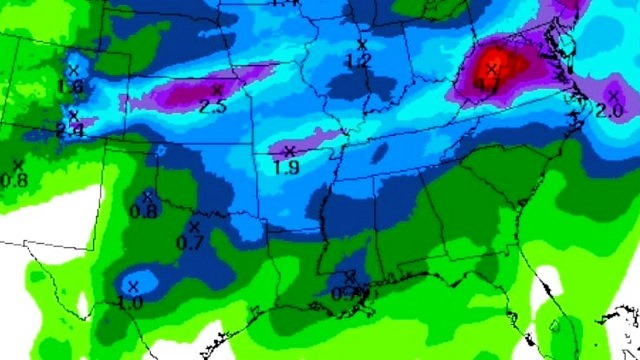
SHOWERS/STORMS RETURN FRIDAY: An upper low is lifting out of the Southwest today, and that feature will bring our next chance of rain Friday. Still looks like the main window for showers and storms will come from noon Friday through midnight Friday night. It certainly won’t rain for the entire 12-hour period, but a few passing showers and storms are likely. In fact, a few strong storms are possible, and the Storm Prediction Center has a decent part of the state under a “marginal risk.”

While instability values will be fairly impressive by Friday afternoon, wind fields are weak. The main threats with the heavier storms will come from small hail and strong, gusty winds. Rain amounts should be one-half inch or less for most communities.
THE ALABAMA WEEKEND: The sky becomes partly to mostly sunny Saturday; the day will be cooler, with a high between 75 and 78 degrees. Then, Sunday will be warm and dry, with sunshine in full supply along with a high in the mid 80s.
NEXT WEEK: A cold, deep upper trough is forecast to park itself over the western U.S. next week, while we have general ridging aloft around here, meaning warm and mostly dry weather Monday through Friday with highs in the 80s.

Click here to see the Beach Forecast Center page.
WEATHER BRAINS: You can listen to our weekly 90-minute netcast anytime on the web, or on iTunes. This is the show all about weather featuring many familiar voices, including meteorologists at ABC 33/40.
CONNECT: You can find me on all of the major social networks:
Facebook
Twitter
Google Plus
Instagram
Pinterest
Snapchat: spannwx
For more weather news and information, visit AlabamaWX.