Brian Peters: Uncertainty abounds in Alabama’s weather this week
Brian Peters: Cloudy day for Alabama brings some rain, cuts heat from Alabama NewsCenter on Vimeo.
If you are faint of heart, you don’t want to be in the weather forecasting business. While the potential for a tropical system affecting the Gulf Coast at midweek remains very high, there is still little we can say about specifically where it is headed. So read on.
TODAY: Yesterday we had a multicell cluster of storms in the Montgomery area, and this morning we have a cluster of storms moving across the Tennessee River Valley.
The big difference is that the storms today are moving, where the storms Sunday morning were moving very little, prompting flash flood warnings. Add to this scenario that we have a cold front draped from near Nashville to near Shreveport, Louisiana. This front will be slowly sagging into Alabama and appears likely to become stationary somewhere in central Alabama, probably between Birmingham and Montgomery. This, along with the open troughiness aloft, should produce numerous showers and thunderstorms today, with rainfall amounts between one-half and 1 inch. Highs today should stay in the middle 80s, thanks to clouds and numerous showers.
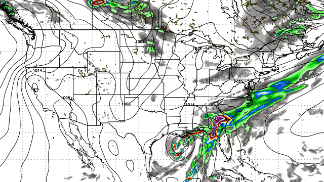
TUESDAY AND THE TROPICS: The Global Forecast System and the European ECMWF model are in fairly close agreement on bringing the broad area of low pressure into the southern Gulf of Mexico tonight and Tuesday. Neither model has a good handle on the situation until that broad area of low pressure gels some and we can identify a circulation center. A Hurricane Hunters aircraft is scheduled to fly into the system later today, and if this flight occurs, we may be able to better identify some sort of circulation center. At 18Z on Tuesday, both models have a tropical system in the central Gulf of Mexico south of New Orleans. This development and position should keep any serious rain over the Gulf water. A slight dip in the dew points thanks to the dissipating front along with clouds and numerous showers once again should keep temperatures down, with highs in the lower 80s.
BIG QUESTIONS FOR WEDNESDAY AND BEYOND: Wednesday the models diverge once again, as the GFS takes the system to the Louisiana coast while the European continues to forecast the left turn and move the tropical system toward Brownsville. The weakness in the 500 millibar flow moves eastward Wednesday, giving me fears that the weakness and the tropical system could become decoupled. If this happens and the tropical system becomes detached from the upper flow, the Lower Mississippi River Valley and parts of the Southeast U.S. could be in for extremely heavy rainfall from Wednesday into Friday as the system meanders without any true direction. We saw something like this with Hurricane Elena in 1985 when it lost the connection to the trough to the north and sat off Clearwater, Florida, for a couple of days. And with the slightly more westward track depicted by the GFS, this changes the weather forecast for north and central Alabama, as we would be on the wet side of the storm. Is this a good time to say, “Stay tuned?”
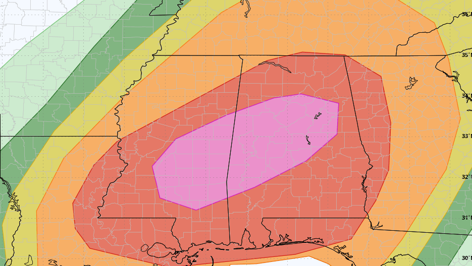
The spaghetti chart as seen below showing the various model tracks continues to be somewhat broad, with no clear consensus. Landfall according to the spaghetti chart could be anywhere between Houston and Destin. As we get closer to the event, we usually see a better clustering of the tracks, but not so for this situation just yet.

As for the forecast between the Wednesday-Thursday time frame, it will all depend on what this tropical system does. For now we wait on getting some better data in hopes of zeroing in on what it will do.
THE ALABAMA WEEKEND: By Friday, the GFS finally begins to move the upper air feature associated with the tropical system eastward in response to another strong trough coming into the western Great Lakes Region. That upper air feature rapidly exits the Southeast by Saturday, with another front settling into the Southeast and ramping up our rain chances yet again. With the overall troughiness across the eastern U.S., we won’t be seeing any extreme heat. Highs through the end of the week and into the weekend should remain in the middle 80s.
AT THE BEACH: The weather at the beach for the next week will be pretty stormy, with passing showers and storms just about each day. Highs will be in the middle 80s. Plus, there is the potential for a tropical system in the Gulf that could produce serious weather issues around the Tuesday-Wednesday time frame. For a detailed look at the weather from Fort Morgan to Panama City Beach, click here to see the AlabamaWx Beach Forecast Center page.
A LOOK AHEAD: Looking into voodoo country, the GFS ramps up the upper ridge for much of week 2. This will mean some really hot weather for much of the central U.S. as the primary ridge axis remains situated just west of the Mississippi River Valley.
Check back for the latest information on a complicated forecast. Have a great day and Godspeed.
James Spann is on vacation. For more weather news and information from Brian Peters and other members of the James Spann team, visit AlabamaWx.