James Spann: Tropical downpours ahead for Alabama
James Spann: Flash flood watches through Thursday for South Alabama from Alabama NewsCenter on Vimeo.
RADAR CHECK: This morning rain is falling across parts of central Alabama, mostly south of a stalled surface front near I-20. The air is drier over the northern third of the state, where few, if any, showers are expected today. But we will forecast a good chance of a few passing showers and storms from Tuscaloosa, Birmingham and Gadsden south. South of the front, where showers are likely, today’s high will be in the low 80s, but upper 80s are likely to the north, where the sky will be brighter.
TROPICAL DOWNPOURS AHEAD: All eyes are on the disturbance in the Gulf of Mexico; it will set the stage for periods of heavy rain and potential for flooding across the Deep South in coming days. Here is the latest.
“POTENTIAL TROPICAL CYCLONE THREE”: We need to mention that this year, for the first time, the National Hurricane Center is issuing forecasts and advisories for systems that have yet to become a depression or storm, but have a high probability of development. The disturbance in the Gulf this morning is not a tropical depression or a tropical storm, but a “potential tropical cyclone.” A cyclone is a broad term that includes a tropical depression, tropical storm and a hurricane; that doesn’t mean that we are now calling hurricanes “cyclones” in our hemisphere.
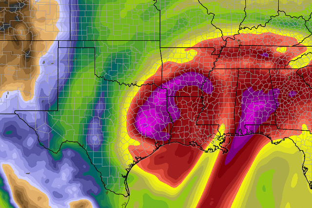
NHC expects the disturbance to become Tropical Storm Cindy within the next 24 hours, and the center of circulation is expected to come ashore around the Sabine Pass on the Texas/Louisiana border early Thursday morning. It is important NOT to focus on the circulation center and the “cone of uncertainty” in this case; copious amounts of tropical moisture and very high precipitable water values will be pulled northward 500 to 600 miles east of that center, and some of the heaviest rain and the highest flood threat most likely is going to be east of the cone.

Flash flood watches cover the Gulf Coast region from southeast Louisiana through the Florida Panhandle, where rain amounts should average 5 inches. But some places could see more than 10 inches, with very significant flooding likely.

NORTH/CENTRAL ALABAMA: Periods of tropical rain and a few thunderstorms are likely tomorrow and Thursday because of the Gulf system. Rain amounts of 2 to 3 inches are likely for places like Tuscaloosa, Birmingham, Anniston and Gadsden, with isolated amounts of 5 inches. A flash flood watch could be required.
We should also mention there is potential for a few isolated, small tornadoes Thursday, as shear values will be high with the tropical system to the west. For now, the severe weather risk defined by the Storm Prediction Center Thursday is west of Alabama, but I would not be surprised if it is pulled eastward into our state.
ALABAMA/NORTHWEST FLORIDA GULF COAST: Flash flood watches are already in effect for places like Gulf Shores, Orange Beach, Pensacola, Destin and Panama City Beach. Rain amounts there will average 5 inches, with potential for 10 inches in spots. The most widespread rain will come tomorrow and Thursday, with showers and storms becoming fewer in number Friday and over the weekend (along with increasing amounts of sun). We are bombarded with questions from people wanting to know if they need to cancel their beach trip. We can’t answer that, since different people have a different opinion of spending time on the coast in rainy weather. If you do go, be ready for soaking tropical rain tomorrow and Thursday, along with very rough surf and dangerous rip currents.
FRIDAY AND THE WEEKEND: Deep tropical moisture will stay in place, so showers and storms remain possible on these three days across north and central Alabama, but the rain won’t be continuous, and the sun will be out at times. Highs will be in the mid 80s.
NEXT WEEK: Global models show drier air creeping down into the northern half of the state, and for now the weather looks mostly dry Monday through Wednesday, with moisture levels creeping back up late in the week.

REST OF THE TROPICS: Tropical Storm Bret is a very low-latitude system; it is hugging the coast of South America this morning as it moves west/northwest. It is expected to dissipate later this week in the Caribbean.
SOLSTICE TONIGHT: With all the tropical weather, the summer solstice occurring at 11:24 p.m. tonight has been lost in the shuffle. But summer officially begins at that moment.
BEACH FORECAST: Click here to see the AlabamaWx Beach Forecast Center page.
WEATHER BRAINS: You can listen to our weekly 90-minute netcast anytime on the web, or on iTunes. This is the show all about weather featuring many familiar voices, including meteorologists at ABC 33/40.
CONNECT: You can find me on all of the major social networks:
Facebook
Twitter
Google Plus
Instagram
Pinterest
Snapchat: spannwx
For more weather news and information, visit AlabamaWx.