Brian Peters: A nice Saturday for Alabama before unsettled weather returns
Brian Peters: Dry air covers northern half of Alabama today, gone tomorrow from Alabama NewsCenter on Vimeo.
TODAY: On the surface map this morning, the cold front has progressed into central Alabama, but it appears likely that it will make it only about as far south as Montgomery. Drier air, as evidenced by dew points in the lower 60s, has made it into the Tennessee River Valley, so I think the area from about Clanton northward will be shower free today, with the best chances for showers to develop over the southern portion of Alabama. With a mix of sun and clouds, look for the highs today to reach near 90 degrees.
SUNDAY: The dry air over the northern third of the state will not last long. Rain chances are expected to climb nicely Sunday, with numerous showers possible across central Alabama. Highs should remain in the upper 80s.
NEXT WEEK: Unfortunately, there appear to be several small short waves that will be traversing the area over the next week. These upper-level disturbances will help to enhance showers and thunderstorms initiated primarily in the heat of the afternoon, so this combination will keep things somewhat unsettled for much of next week. Timing these weak, fast-moving short waves can be difficult, so you may see adjustments to forecasts as the influence of these disturbances becomes clearer.
With clearly adequate moisture, we’ll be keeping some mention of showers and thunderstorms every day. The good news is that increased cloud cover and the presence of numerous showers will keep our afternoon highs in check, with the middle 80s most days — a range of about 84 to 87. Your high will depend on the precise amount of clouds at your location as well as the time you see a shower. Morning lows should be pretty uniform, with values mainly in the lower 70s, a range of 69 to 74.
The presence of a weak frontal boundary will pose the potential for isolated severe thunderstorms across north and central Alabama on Tuesday. The Storm Prediction Center has this area in a marginal severe weather risk, with damaging wind and marginally severe hail the most likely threats. Rainfall will vary significantly because it will come from thunderstorms. Overall through next Thursday, rainfall amounts of 1 to 3 inches will be possible, so we’ll need to be vigilant for the possibility of localized flash flooding each day. This threat will depend in part on how slow or fast the thunderstorms move.
TROPICS: The tropical Atlantic contained two areas of disturbed weather, one south-southwest of the Cabo Verde Islands and the other in the south central Caribbean. The one in the far eastern Atlantic is likely to move on a westerly course, and conditions could become more favorable for some development early next week. Unlike the runs yesterday, the Global Forecast System has switched over to the idea of no significant development of that system, in agreement with the ECMWF model. The one in the Caribbean could reach the southwest Gulf of Mexico around Wednesday, a solution supported by both the GFS and the ECMWF. It’s projected to move into the southern coast of Mexico. There is one depression in the eastern North Pacific that is not forecast to develop and should dissipate by Sunday night.
BEACH FORECAST: At the beaches of Alabama and northwest Florida, the chance for showers will continue this weekend and into much of next week. No complete washouts, but showers could be fairly numerous at times today. You can expect to see highs mainly in the middle 80s and lows in the upper 70s. There is a moderate risk for rip currents today. Click here to see the AlabamaWx Beach Forecast Center page.
A LOOK AHEAD: Looking out into voodoo country, the GFS has gone more bullish on nosing the Bermuda high into and across the Southeast. The high begins to build into the Southeast around Aug. 13-14 and noses all the way to Texas by Aug. 16. The upper ridge is maintained across the southern tier of the U.S. until Aug. 18. That would mean some warm days, but it probably would not be anything warmer than the middle 90s.
WEATHER BRAINS: You can listen to our weekly 90-minute netcast anytime on the web, or on iTunes. This is the show all about weather featuring many familiar voices, including meteorologists at ABC 33/40.
Have a great day, and Godspeed.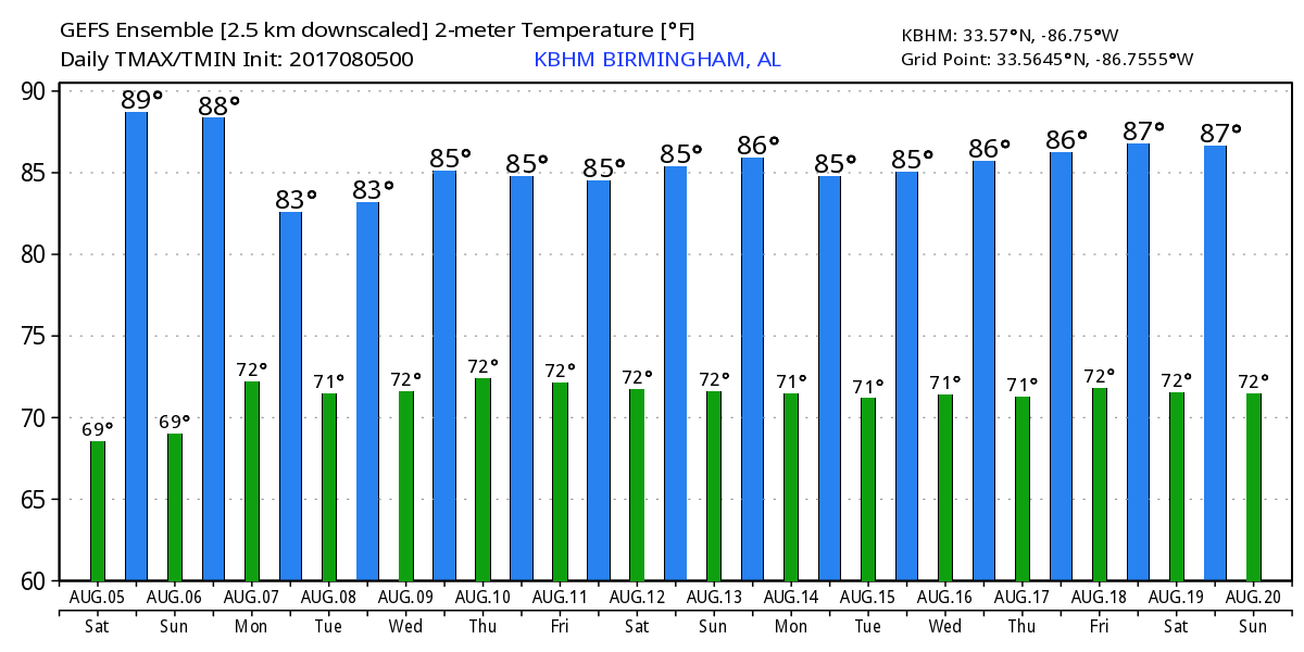
For more weather news and information, visit AlabamaWx.