James Spann: Showers more widely spaced this afternoon in Alabama
A CALMER AFERNOON: There’s not much to see on weather radar this afternoon; we have showers and storms over parts of west Alabama, but many communities are dry with a partly sunny sky. Temperatures are mostly in the 87- to 90-degree range. Showers will end once the sun goes down.
TOMORROW/FRIDAY: We will keep a persistence forecast going — partly sunny days with scattered, mostly afternoon and evening showers and thunderstorms. The chance of any one spot getting wet both days is about 1 in 3, and we expect afternoon highs mostly between 88 and 92 degrees. Very typical August weather.
THE ALABAMA WEEKEND: Drier air is expected to creep into the northern half of Alabama, meaning a good supply of sunshine and only isolated afternoon showers or storms Saturday and Sunday. Highs will creep up into the low to mid 90s as drier air heats more effectively.
ECLIPSE WEATHER: Over north Alabama, Monday’s solar eclipse will run roughly from noon to 3 p.m., with the peak coming around 1:30. It looks like a routine summer day, meaning the sky should be partly sunny for most of those three hours with a field of scattered to broken cumulus clouds. A few scattered showers or storms will be possible, but there is no way of knowing in advance when and where they form. The bottom line is that you should be able to see some, if not all, of the eclipse.
Be sure you watch the eclipse safely with the right eyewear. Get more details here from NASA.
REST OF NEXT WEEK: No reason to depart from the standard summer mix of sun and scattered afternoon storms each day for the rest of the week with highs around 90 degrees.

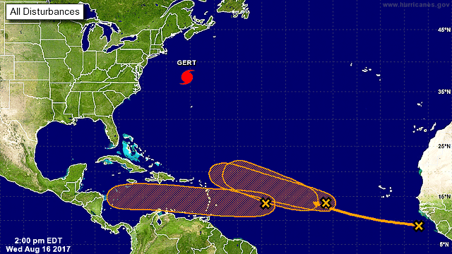
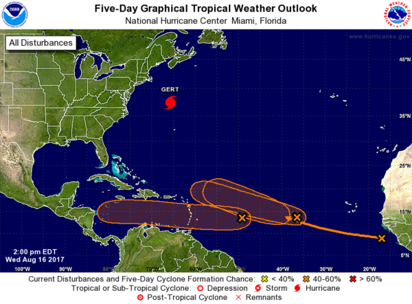
TROPICS: Gert is now a category two hurricane in the Atlantic, well east of New Jersey, with sustained winds of 100 mph. It is moving east/northeast and is no threat to land. It will become post tropical this weekend over the North Atlantic.
There are three tropical waves scattered across the Atlantic from the Lesser Antilles to the coast of Africa; all three have some chance of developing slowly in coming days.
The lead wave, Invest 91L, is expected to cross the Caribbean and move into Central America in five days or so. There’s a good chance it will be a tropical storm, and possibly a hurricane.
The next trailing wave, Invest 92L, is forecast to be somewhere near the Bahamas in five days. It will face a somewhat challenging environment, but there is some potential for this to become a tropical storm. It remains to be seen whether this will enter the Gulf of Mexico, threaten the U.S. East Coast or recurve into the open Atlantic.
The third wave most likely will be tagged “Invest 93L” and could develop slowly on the journey westward over the next seven days.
BEACH FORECAST: Click here to see the AlabamaWx Beach Forecast Center page.
WEATHER BRAINS: You can listen to our weekly 90-minute netcast anytime on the web, or on iTunes. This is the show all about weather featuring many familiar voices, including meteorologists at ABC 33/40.
CONNECT: You can find me on all of the major social networks:
Facebook
Twitter
Google Plus
Instagram
Pinterest
Snapchat: spannwx
For more weather news and information, visit AlabamaWx.


