James Spann: Windy, wet in Alabama through tonight; weather improves Tuesday
James Spann: Irma visits Alabama, bringing wind, rain, but no tornadoes from Alabama NewsCenter on Vimeo.
IRMA WEAKENING AND HEADED OUR WAY: The large rain shield associated with Irma is moving into the Birmingham metro area as I write this early this morning; that rain will overspread most of the state during the day today and continue tonight. Southwest Alabama, however, will stay dry for the most part — places like Mobile, Jackson, Grove Hill and Gulf Shores.
IRMA THIS MORNING: She is now a minimal hurricane north of Tampa Bay with sustained winds of 75 mph. The system will weaken to a tropical storm later this morning.
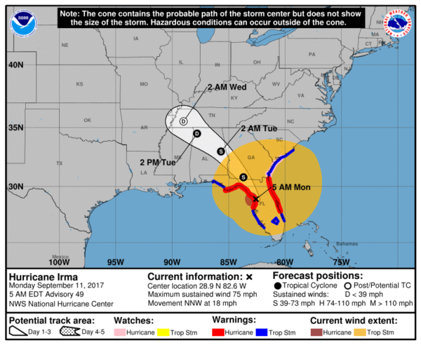
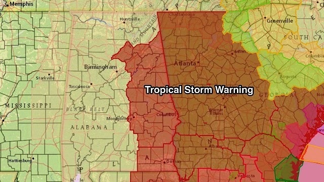
The circulation will hook to the left, moving across north Alabama tonight, and will bring increasing wind to our state. A tropical storm warning remains in effect for many east and southeast counties; a wind advisory is in effect for all the counties in the state.
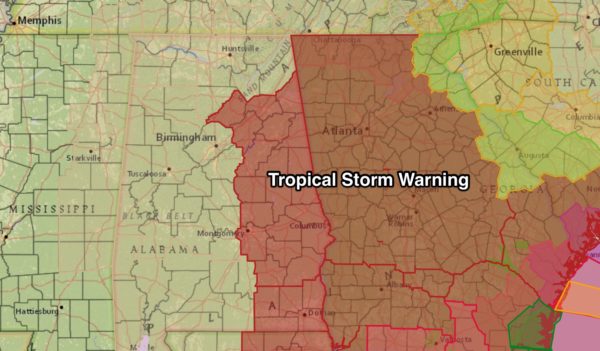
The tropical storm warning includes places like Gadsden, Anniston, Sylacauga, Alexander City, Auburn, Montgomery, Troy and Dothan. It does not include Birmingham or Huntsville.
WHAT TO EXPECT: The highest winds across Alabama will come from about noon today through 6 a.m. tomorrow. Winds over the eastern counties, in the tropical storm warning, will average 30-40 mph with higher gusts, especially on ridges. For the rest of the state in the wind advisory, winds will average 20-30 mph with an occasional higher gust.
We would see some scattered tree and power line damage, especially over east Alabama, late this afternoon and tonight.
Rain amounts of 2 to 4 inches are possible over east Alabama, with 1 to 2 inches for the rest of the state between now and early tomorrow morning. Major flooding issues are not expected. And there is no risk of tornadoes in Alabama today; that threat is well to the east, along the coasts of Georgia and South Carolina.
Today will be very cool with rain and gusty winds; we won’t get out of the 60s. It sure won’t feel like early September.
TOMORROW: Rain will end very early tomorrow, and winds will die down during the day. In fact, the sun could break out tomorrow afternoon. The weather stays cool with a high in the 60s.
WEDNESDAY THROUGH FRIDAY: We will hang on to the risk of a few widely scattered showers Wednesday and Thursday with a mix of sun and clouds and a warming trend. The high Wednesday will be in the mid 70s, followed by low 80s Thursday. Friday looks warm and dry with a good supply of sunshine and a high in the mid to upper 80s.
THE ALABAMA WEEKEND: For now it looks warm and dry with ample sunshine Saturday and Sunday; highs will be in the mid to upper 80s, lows in the 60s.
NEXT WEEK: An upper ridge holds, meaning warm and dry weather for at least the first half of the week.
GULF COAST WEATHER: As we have discussed here for days, there won’t be much impact from Irma for places like Gulf Shores, Pensacola, Navarre Beach and Destin. Just a gusty north wind and a few showers.
Panama City Beach will see some rain today and a north wind of 20-35 mph, but no storm surge, no risk of tornadoes and no real problems. The rest of the week looks good along the coast with partly sunny, warm days and only widely scattered showers. Highs in the 80s.
HURRICANE JOSE: The other hurricane in the Atlantic basin will do a loop over open water in coming days.
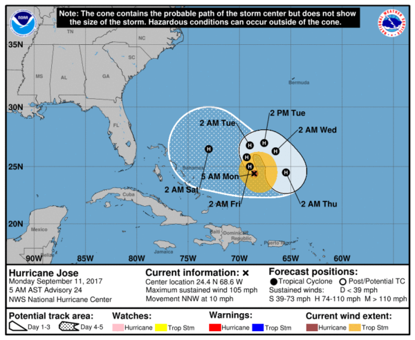
Longer-range guidance suggests this will move northeast into the open Atlantic, just off the northeast coast of the United States, in five to six days. There’s still some uncertainty involved.
WEATHER BRAINS: You can listen to our weekly 90-minute netcast anytime on the web, or on iTunes. This is the show all about weather featuring many familiar voices, including meteorologists at ABC 33/40.
CONNECT: You can find me on all of the major social networks:
Facebook
Twitter
Google Plus
Instagram
Pinterest
Snapchat: spannwx
For more weather news and information from James Spann and his weather team, visit Alabama Wx.


