James Spann: Fall arrives today, but summer weather lingers in Alabama
James Spann: The season changes today, but Alabama weather doesn’t from Alabama NewsCenter on Vimeo.
THE DAY OF THE EQUINOX: The autumnal equinox is today at 3:02 p.m. That is when the sun will be directly over the equator, and we have approximately 12 hours of daylight and 12 hours of darkness. While fall “officially” arrives, it will still feel like summer, with temperatures reaching the upper 80s again today. And, like recent days, a few showers and storms are possible this afternoon and early tonight, but they should be widely separated.
THE ALABAMA WEEKEND: No real change; an upper ridge continues over the eastern United States. Expect partly sunny days, fair nights and a few afternoon and evening showers and thunderstorms in random, widely scattered spots. Highs for the weekend will be in the mid to upper 80s, about 5 degrees above average for late September.
FOOTBALL WEATHER: For tonight’s high school games, it will be warm and humid, with temperatures falling from the low 80s at kickoff into the upper 70s by the final whistle. Just a slight risk of a shower during the first quarter.
Alabama will be in Nashville Saturday to take on the Vanderbilt Commodores (2:30 p.m. kickoff). The sky will be mostly sunny with a kickoff temperature near 88 degrees, falling into the mid 80s by the fourth quarter. Just an outside risk of a brief shower or storm.
Auburn is also on the road, playing Missouri in Columbia Saturday evening (6:30 p.m. kickoff). We expect a clear sky with temperatures falling from 85 degrees at kickoff into the upper 70s by the final whistle.
And UAB is also traveling this weekend, playing North Texas Saturday evening (5:30 p.m. kickoff) in Denton. The weather will be dry with a fair sky; about 90 degrees at kickoff, falling through the 80s during the game.
NEXT WEEK: The warm, humid weather continues though midweek with isolated afternoon showers and storms, but a pattern change begins toward the end of next week. An upper trough will begin to carve out over the eastern U.S., and a cold front will bring a better coverage of showers and thunderstorms by Friday. Then, cooler, drier air arrives for the following weekend as October begins.
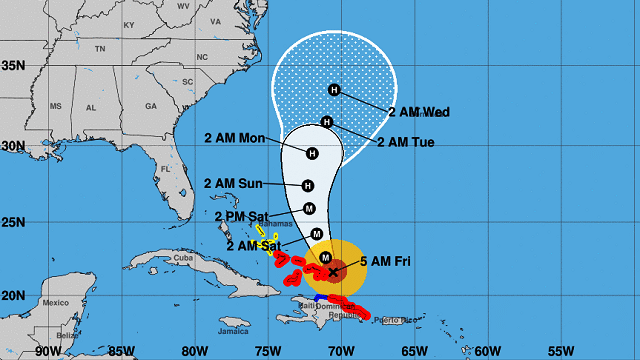
MARIA STILL A CATEGORY THREE HURRICANE: Maria is packing sustained winds of 125 mph and is moving toward the northwest near 7 mph. A motion toward the north-northwest is expected later today and tomorrow. On the forecast track, Maria’s eye will move near or just east of the Turks and Caicos Islands and southeastern Bahamas today.
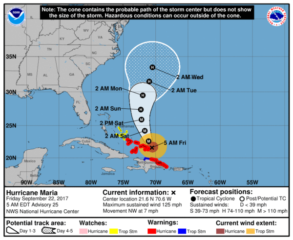
Maria should be between the North Carolina Outer Banks and Bermuda by the middle of next week as a category 1 hurricane, and most global model guidance continues to show the center remaining offshore as it moves north/northeast beyond that point.
Jose is now a “post tropical” cyclone off the New England coast; it will hang around for few more days before dissipating.
BEACH FORECAST: Click here to see the AlabamaWx Beach Forecast Center page.
WEATHER BRAINS: You can listen to our weekly 90-minute netcast anytime on the web, or on iTunes. This is the show all about weather featuring many familiar voices, including meteorologists at ABC 33/40.
CONNECT: You can find me on all of the major social networks:
Facebook
Twitter
Google Plus
Instagram
Pinterest
Snapchat: spannwx
For more weather news and information from James Spann and his weather team, visit Alabama Wx.


