Brian Peters: Slight warm-up for Alabama today, but week stays chilly
Brian Peters: Here comes the sun, Alabama from Alabama NewsCenter on Vimeo.
TODAY: Some cirrus clouds still appear in the morning satellite image over the northern third of Alabama, but they are fairly thin, so I’m expecting to see a mostly sunny day. The sunshine should help us get out of the deep freeze, with highs today around the 50-degree mark. That should feel pretty nice after a high of only 39 degrees at the Birmingham Shuttlesworth International Airport yesterday. Even at 50 degrees, that’s still 4 degrees below our 30-year seasonal averages for Dec. 26.
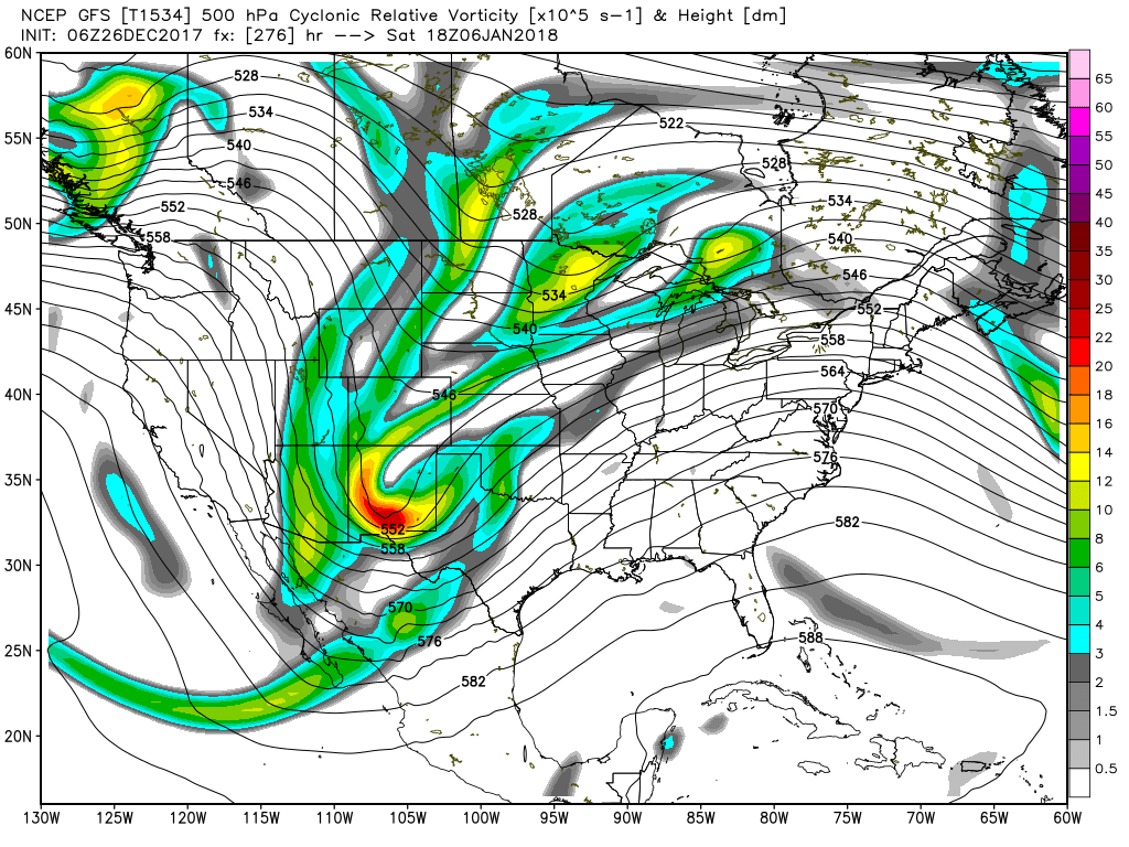
COLD FOR A WHILE? When it comes to the computer guidance, we’re still dealing with model madness as the two major global models remain at odds. The upper air pattern is still stuck in the broad trough across nearly all of the U.S. And it looks like this cold pattern will not be changing significantly for the next 10 to 11 days.
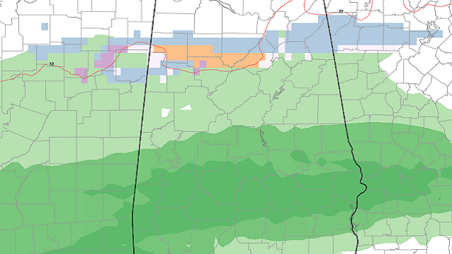
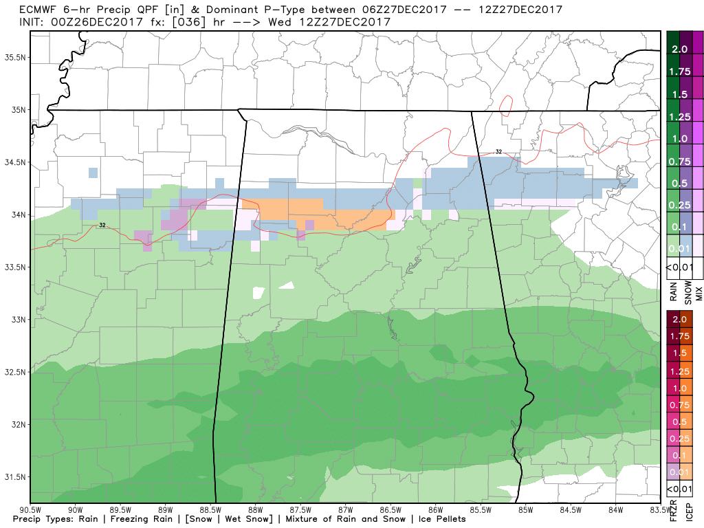
REST OF THE WEEK: An overrunning pattern is forecast to develop later today and advance eastward. There are still some slight differences on just how far north the precipitation will push, but the Global Forecast System and ECMWF are much closer on this run. The ECMWF is a tad farther north than the GFS – see the graphic below – and we could see the precipitation begin as a mix of rain, sleet and freezing rain between about 3 a.m. and 9 a.m. The current diagnosis suggests this will be short-lived and very light, without any significant impacts for travel, but with the early morning temperatures Wednesday sitting around the freezing mark, we’ll need to be carefully watching the developments then. The GFS suggests the precipitation will be farther south without any wintry mix at all.
Thursday and Friday, both models depict the upper air pattern sticking with the broad trough, so we are not going to get very warm with the afternoon highs in the 40s and morning lows in the upper 20s to lower 30s. Both models depict a continuation of the overrunning situation, but both are showing the precipitation over south Alabama and the Gulf Coast area. On Friday a strong trough moving through the Great Lakes will sharpen the trough aloft just a bit, resulting in pushing the overrunning area farther south and east.
THE ALABAMA WEEKEND: For the weekend into New Year’s Day the forecast is downright challenging, since the two global models are in no way agreeing. This means the confidence in the forecast from five to eight days out is low — very, very low, when you consider that one model shows precipitation and the other model shows complete dryness. The real solution is probably a mix, since we often see the two models grow closer to each other with time. In the meantime, everyone wants a forecast for what is likely to be a complicated situation.
The broad upper trough is still in place on Saturday, so the forecast looks to remain cold but dry, with highs around the 50-degree mark. Sunday another big change is forecast by the GFS, with a strong trough moving southward across the western Great Lakes and the short wave over Baja, Calif., ejecting eastward. The GFS is quite bullish on precipitation across the Lower Mississippi River Valley, while the ECMWF is completely dry for the Southeast with precipitation across the Gulf of Mexico. So which do you pick? To add additional trouble to the forecast, the GFS is suggesting a broad band of freezing precipitation across the northern third of Alabama, roughly along and north of the I-20 corridor. I think the safest bet for the forecast is to do what the National Weather Service forecast has done, and put in a chance of rain, light sleet or snow. This is on the edge of voodoo, so we’re pretty sure models will have a better handle was we get closer to the event. If the GFS is correct, the timing for the precipitation would be from late Sunday afternoon through early Monday morning.
FREEZING NEW YEAR: That trough coming across the Great Lakes on Sunday is forecast to dig into the Ohio River Valley, promising still colder weather to start 2018. The good news is that the GFS pushes the dry air well south, too, so while Jan. 1-2 will be cold, there should not be any concern for winter weather. By the way, this is depicted as brutally cold air, with the GFS MOS guidance printing out 14 degrees for the low on Monday and 8 for the low on Tuesday. And Monday the GFS is forecasting a high of only 23 degrees. BRRRRRRRRRRR!!
LONG TERM: Looking out into voodoo country, the message we’ve been getting remains the same – an active and generally cold pattern. There is another upper trough coming across the Lower Mississippi River Valley around Jan. 4. But that is followed by a deep trough digging into New Mexico, which would pump up the ridge over the eastern half of the country and return us to some warmer weather. That trough ejects across the Southeast around Jan. 8, providing a pattern that would bring the cold trough back to the eastern U.S.
BEACH FORECAST: Click here to see the AlabamaWx Beach Forecast Center page.
WEATHER BRAINS: You can listen to our weekly 90-minute netcast anytime on the web or on iTunes. This is the show all about weather featuring many familiar voices, including meteorologists at ABC 33/40.
REMINDER: While James Spann is on vacation, we’re maintaining a one-a-day forecast schedule. Be sure to catch Charles Daniel on ABC 33/40 at 4, 5, 6 and 10 p.m. today with the latest weather forecasts. Have a great day. Godspeed.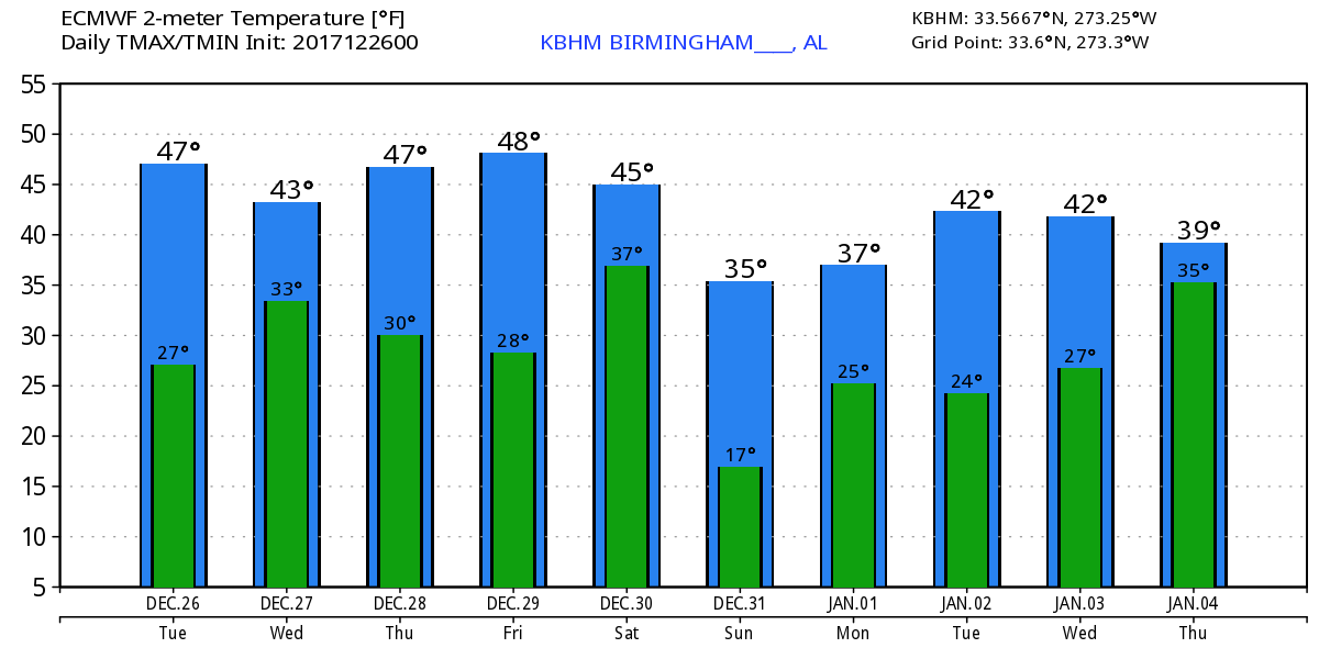 For more weather news and information from Brian Peters, James Spann and other members of the James Spann team, visit AlabamaWx.


